
Gielow
| coat of arms | Germany map | |
|---|---|---|

|
Coordinates: 53 ° 42 ' N , 12 ° 45' E |
|
| Basic data | ||
| State : | Mecklenburg-Western Pomerania | |
| County : | Mecklenburg Lake District | |
| Office : | Malchin at the Kummerower See | |
| Height : | 28 m above sea level NHN | |
| Area : | 23.47 km 2 | |
| Residents: | 1070 (Dec. 31, 2019) | |
| Population density : | 46 inhabitants per km 2 | |
| Postal code : | 17139 | |
| Area code : | 039957 | |
| License plate : | MSE, AT, DM, MC, MST, MÜR, NZ, RM, WRN | |
| Community key : | 13 0 71 039 | |
| Community structure: | 5 districts | |
| Office administration address: | Am Markt 1 17139 Malchin |
|
| Website : | ||
| Mayor : | Udo Kahlert | |
| Location of the community Gielow in the Mecklenburg Lake District | ||
  |
||

Gielow is a municipality in the Mecklenburg Lake District in Mecklenburg-Western Pomerania . It is located about six kilometers south of the city of Malchin and belongs to the Malchin district on Lake Kummerower .
geography
Geographical location
The municipality is located five kilometers south of Malchin and 6.5 kilometers east of Lake Malchin. It lies on a wavy plateau at 40 to 70 meters above sea level , the municipal boundary is accompanied by strips of forest. East of the municipality is the erosion valley of the Ostpeene.
Community structure
The community consists of the districts:
- Gielow
- Hinrichsfelde
- Liepen
- Christinenhof
- Peenhauser
Neighboring communities
clockwise, starting from north:
politics
coat of arms
|
|
Blazon : "In green a fallen golden horseshoe with eight nail holes, between the studs a golden abbot with a broken shaft."
The coat of arms and the flag were designed by Karl-Heinz Steinbruch from Schwerin . It was approved on May 28, 2003 by the Ministry of the Interior and registered under the number 279 of the coat of arms of the state of Mecklenburg-Western Pomerania. |
| Justification of the coat of arms: The coat of arms symbolizes the historical and economic conditions of the community. With the broken abbot's staff, reference is made to Gielow's affiliation to the former Cistercian monastery Dargun. The horseshoe stands for traditional agriculture as well as for the numerous craftsmen and traders in the village. |
flag

The flag was approved by the Ministry of the Interior on July 3, 2003.
The flag is made of yellow cloth. It is covered in the middle with the municipal coat of arms, which takes up two thirds of the height and one third of the length of the flag cloth. The length of the flag is related to the height as 5: 3.
Official seal
The official seal shows the municipal coat of arms with the inscription "GEMEINDE GIELOW".
history
Gielow
Gielow was first mentioned on August 5, 1228. In a document, Duke Wartislaw III confirmed . from Pomerania a donation from Gielow to the Dargun monastery . From 1409 to 1618 the place was under the influence of the von Maltzahn family . They had signed a protection agreement with the Dargun monastery. With the purchase of the rights to Gielow by Duke Georg Hans Albrecht, the place then passed into state rule.
The introduction of freedom of trade in 1866 developed in Gielow, which until then largely agriculturally was marked, the craft . In 1879 the Waren – Malchin railway was put into operation. This also improved Gielow's economic development. In 1894 a dairy and in 1899 a milk sugar factory were built in the village. This also resulted in an increase in the population. At the beginning of the 20th century there were already around 1500 people in Gielow.
In 1927 a gymnastics and sports club were founded in Gielow.
During the Second World War , forced laborers from Poland had to work in the local lime works. A Pole who died in the process and a French slave laborer were buried in the cemetery of the Evangelical Lutheran Parish - a memory of them is missing.
In the time of the GDR there was also a collectivization of agriculture in Gielow . In 1960 the last farmers in the community were incorporated into the local LPG . In 1967 a cattle combine was founded in Gielow. The merger of the LPG in Gielow with the Schwinkendorfs in 1974 and the establishment of the Cooperative Plant Production Department (KAP) further strengthened the new structures within the local agriculture.
In 1976 the kindergarten built during the GDR era was given a new building. In 1980 the Gielows school , which was built in 1884, was expanded to include a gymnasium and a boiler room. A school extension followed a year later.
After the political turnaround in the GDR and reunification , private businesses were founded in Gielow, particularly in the fields of wood processing, building trade, agriculture and trade. The neglected infrastructure (roads, sewage treatment plant) was renewed.
Due to the merger of the Malchin-Land Office with the city of Neukalen on July 1, 2002, Gielow belongs to this new regional authority , after it was previously one of the municipalities of the Malchin-Land Office.
Hinrichsfelde
Around 1880 the place only consisted of a manor, a little to the south there was only a farm workers' cottage. The estate was very compact and had a manor house and a park. During the GDR era, an LPG complex was built next to the remaining manor buildings, which was modernized after 1990.
Liepen
In the middle of the small town is the large pond with the castle. It was originally a tower hill castle with a moat and medieval foundations on which a manor house was built. An earth dam leads to the island in place of the former drawbridge, which was still there in 1756. It is only three feet high. Several buildings stand on it, such as the lovely old manor house, which has a high, steep late-Gothic roof. On the ground floor there are late medieval barrel vaults made of large bricks in the so-called monastery format. It can be assumed that the hill was divided into a main castle and an outer castle, separated by a moat. In 1997/1998 the moated castle was restored.
To the east of the moated castle the manor was established, which was expanded considerably until the 1880s. To the south of the estate, a row of agricultural workers can still be seen today. After 1920, a new manor house was built a little further west, which is still there today. It's in a small park.
The "Liepener Theerofen" desert is located about two kilometers to the east . In the second half of the 19th century, a day laborer's cottage and a school building (for Demzin and Liepen) were built near the old former tar stove. Both were abandoned around 1960 and fell into disrepair. In 1999 the foundations were exposed and refurbished. This settlement, which formerly belonged to Liepen, no longer belongs to the municipality today.
After 1945 the village developed into a larger settlement because many houses and farms were built as a result of the land reform.
According to the latest information (through a guided tour of Basedow Castle), the Hahn family (branch line of the Basedower Hahns) acquired the Liepen moated castle after unsuccessful bidding at the Basedower Castle auction and also lives in it.
On January 1, 1951, Liepen was incorporated.
Christinenhof
Before 1945, the Christinenhof belonged to Hahn's possessions. It was a property with a Vorwerk character. The former manor house shows the year of construction 1870 in a round panel of the dwarf house standing across the longitudinal front. To the south-west of the courtyard there was an associated brickworks and to the south-east a pheasantry was established in a small forest area. After the land reform of 1945, the place was expanded by some settlement farms.
Peenhauser
Peenhäuser owes its name to the nearby Ostpeene. It was a long farming village.
Attractions
→ See also the list of architectural monuments in Gielow

- The Gielow Church has its origins in the 14th century. In the 15./16. The church tower was built in the 16th century. During the renovation in 1897/98, the church building was extended to the east in a cross shape, the windows and the west portal were renewed and the interior was furnished with Gothic wood furnishings. The furnishings include a granite baptism from the 13th century, decorated with relief heads and leaf decoration.
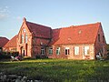
- The Gielower mill goes back to the time of Gielow's settlement and was rebuilt in 1872 as a four-storey building after the fire of the old mill. Traditionally, flour and animal feed were ground here. After 1991, the plant was rebuilt to generate energy.
- The Liepen moated castle was built in the Middle Ages. During the restoration of the moat, wooden beams from the 15th century were found. But it fell apart after the Thirty Years' War. Today's manor house was built on the castle island around 1700 in the rural baroque style. The outbuildings are more recent. The estate belonged to the von Hahn family (from 1337). Today the monument preservation farm is located in the property.
- Christinenhof estate, built in 1870 by the von Hahn family
- In the vicinity of the municipality there are some large stone graves and stone box graves (both from the Neolithic) as well as Bronze Age barrows.
- In the vicinity of the municipal boundary there are a number of boundary stones that are rare.

Gielower Mill

Liepen moated castle
Christinenhof manor


Web links
Individual evidence
- ↑ Statistisches Amt MV - population status of the districts, offices and municipalities 2019 (XLS file) (official population figures in the update of the 2011 census) ( help ).
- ↑ Hans-Heinz Schütt: On shield and flag production office TINUS, Schwerin 2011, ISBN 978-3-9814380-0-0 , p. 284/285.
- ↑ a b main statute § 1 (PDF).
- ↑ Uwe Schwarz: The lower aristocratic fortifications of the 13th to 16th centuries in the Neubrandenburg district. Berlin 1987
Alt Schwerin | Altenhagen | Altenhof | Altentreptow | Ankershagen | Bartow | Basedow | Beggerow | Ownership | Blankenhof | Blankensee | Flower wood | Bollewick | Borrentine | Bredenfelde | Breesen | Breest | Briggow | Brunn | Buchholz | Stargard Castle | Burow | Bütow | Carpin | Cölpin | Dargun | Datzetal | Demmin | Eldetal | Rotten rust | Feldberger Seenlandschaft | Fincken | Friedland | Five lakes | Galenbeck | Gielow | Gnevkow | Godendorf | Goehren-Lebbin | Golchen | Gotthun | Grabowhöfe | Grammentin | Grapzow | Grischow | Large trowel | Groß Miltzow | Gross Nemerow | Large plastic | Groß Teetzleben | Grünow | Validity | Gülzow | High Wangelin | Hohenbollentin | Hohenmocker | Hohenzieritz | Holldorf | Ivenack | Jabel | Jürgenstorf | Kargow | Kentzlin | Kieve | Kittendorf | Little Thank You | Kletzin | Klink | Klocksin | Knorrendorf | Kratzeburg | Kriesow | Sublank | Kuckssee | Kummerow | Larz | Leizen | Lindenberg | Lindetal | Malchin | Malchow | Meesiger | Melz | Mirow | Möllenbeck | Möllenhagen | Mölln | Moltzow | Neddemin | Neetzka | Neubrandenburg | Neuenkirchen | Recalculation | Neustrelitz | Neverin | Nossendorf | Nossentiner Hut | Peenehagen | Penkow | Penzlin | Pragsdorf | Priborn | Priepert | Pripsleben | Rechlin | Ritzerow | Röbel / Müritz | Röckwitz | Rosenow | Sarov | Schloen-Dratow | Schönbeck | Schönfeld | Schönhausen | Black | Siedenbollentin | Siedenbrünzow | Sietow | Silz | Sommersdorf | Sponholz | Staven | Stavenhagen | Steer | Südmüritz | Torgelow am See | Trollenhagen | Tützpatz | Userin | Utzedel | Forgive | Voigtsdorf | Vollrathsruhe | Walow | Waren (Müritz) | Warrenzin | Werder | Wesenberg | Wildberg | Woggersin | Wokuhl-Dabelow | Wolde | Woldegk | Wulkenzin | Wustrow | Zettemin | Zirzow | Zislow