
Knorrendorf
| coat of arms | Germany map | |
|---|---|---|

|
Coordinates: 53 ° 38 ' N , 13 ° 4' E |
|
| Basic data | ||
| State : | Mecklenburg-Western Pomerania | |
| County : | Mecklenburg Lake District | |
| Office : | Stavenhagen | |
| Height : | 58 m above sea level NHN | |
| Area : | 28.51 km 2 | |
| Residents: | 555 (Dec. 31, 2019) | |
| Population density : | 19 inhabitants per km 2 | |
| Postal code : | 17091 | |
| Area code : | 039602 | |
| License plate : | MSE, AT, DM, MC, MST, MÜR, NZ, RM, WRN | |
| Community key : | 13 0 71 079 | |
| LOCODE : | DE KD9 | |
| Community structure: | 6 districts | |
| Office administration address: | Castle 1 17153 Stavenhagen |
|
| Website : | ||
| Mayor : | Sebastian Henke | |
| Location of the municipality of Knorrendorf in the Mecklenburg Lake District | ||
  |
||

Knorrendorf is a municipality in the Mecklenburg Lake District . It is located northwest of Neubrandenburg and belongs to the Stavenhagen office , which has its administrative headquarters in the Reuterstadt Stavenhagen .
Geography and traffic
Knorrendorf is about 14 kilometers southeast of Stavenhagen and 16 kilometers northwest of Neubrandenburg . The federal road 104 and the Bützow – Szczecin railway cross the community. In the northeast lies the Kastorfer See and south of it the Gädebehner See .
The districts of the community are Gädebehn, Friedrichsruh, Kleeth, Kleeth-Siedlung, Kastorf and Knorrendorf.
history
Knorrendorf is a former manor village, the basic structure of which can hardly be read in today's village structure. The former manor house and a village pond have been preserved. The estate was owned by the von Zülow family from ancient times until 1932 . In 1760 the Oldenburg family was named as the owner.
The districts of Friedrichsruh, Gädebehn, Kastorf and Kleeth were originally manor villages. Kastorf has a symmetrically laid out manor. The castle and some farm buildings have been preserved. Gut Kleeth was managed by Count Königsmark in the 1920s. Kleeth was resettled in the 1930s.
On January 1, 1951, the community of Knorrendorf was created through the merger of the forerunner communities of Kastorf and Kleeth.
politics
Coat of arms, flag, official seal
The municipality has no officially approved national emblem, neither a coat of arms nor a flag. The official seal is the small state seal with the coat of arms of the state of Mecklenburg. It shows a looking bull's head with a torn off neck fur and crown and the inscription "GEMEINDE KNORRENDORF • LANDKREIS MECKLENBURGISCHE SEENPLATTE".
Attractions
→ See also the list of architectural monuments in Knorrendorf
- Manor house (castle) Kastorf from the beginning of the 18th century and neo-Gothic renovation in the 19th century; three-storey, nine-axis plastered building with central risalit and stepped gable
- Kastorf estate park with dendrological features
- Evangelical Church Kastorf as a brick building from 1788 with cemetery
- Gädebehn manor from around 1850 as a two-storey, 13-axis renovated plastered building with a medium risalit , today a restaurant
- Gutshaus Kleeth, clinkered, renovated building with a mansard roof , probably from around 1860, around 1955 demolition of a wing of the formerly T-shaped complex
- Yugoslavian ramparts Gädebehn - earth walls are no longer visible
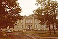
Knorrendorf Manor, around 1980
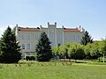
Manor house in Kastorf

Church in Kastorf


Personalities
- Conrad Lüder von Pentz (1728–1782) born officer and genealogist in Gädebehn
Web links
Individual evidence
- ↑ Statistisches Amt MV - population status of the districts, offices and municipalities 2019 (XLS file) (official population figures in the update of the 2011 census) ( help ).
- ↑ Leopold von Ledebur : Adelslexikon der Prussischen Monarchy . Volume 2, Berlin 1856, p. 165
- ↑ Main Statute, Section 1, Paragraph 2
Alt Schwerin | Altenhagen | Altenhof | Altentreptow | Ankershagen | Bartow | Basedow | Beggerow | Ownership | Blankenhof | Blankensee | Flower wood | Bollewick | Borrentine | Bredenfelde | Breesen | Breest | Briggow | Brunn | Buchholz | Stargard Castle | Burow | Bütow | Carpin | Cölpin | Dargun | Datzetal | Demmin | Eldetal | Rotten rust | Feldberger Seenlandschaft | Fincken | Friedland | Five lakes | Galenbeck | Gielow | Gnevkow | Godendorf | Goehren-Lebbin | Golchen | Gotthun | Grabowhöfe | Grammentin | Grapzow | Grischow | Large trowel | Groß Miltzow | Gross Nemerow | Large plastic | Groß Teetzleben | Grünow | Validity | Gülzow | High Wangelin | Hohenbollentin | Hohenmocker | Hohenzieritz | Holldorf | Ivenack | Jabel | Jürgenstorf | Kargow | Kentzlin | Kieve | Kittendorf | Little Thank You | Kletzin | Klink | Klocksin | Knorrendorf | Kratzeburg | Kriesow | Sublank | Kuckssee | Kummerow | Larz | Leizen | Lindenberg | Lindetal | Malchin | Malchow | Meesiger | Melz | Mirow | Möllenbeck | Möllenhagen | Mölln | Moltzow | Neddemin | Neetzka | Neubrandenburg | Neuenkirchen | Recalculation | Neustrelitz | Neverin | Nossendorf | Nossentiner Hut | Peenehagen | Penkow | Penzlin | Pragsdorf | Priborn | Priepert | Pripsleben | Rechlin | Ritzerow | Röbel / Müritz | Röckwitz | Rosenow | Sarov | Schloen-Dratow | Schönbeck | Schönfeld | Schönhausen | Black | Siedenbollentin | Siedenbrünzow | Sietow | Silz | Sommersdorf | Sponholz | Staven | Stavenhagen | Steer | Südmüritz | Torgelow am See | Trollenhagen | Tützpatz | Userin | Utzedel | Forgive | Voigtsdorf | Vollrathsruhe | Walow | Waren (Müritz) | Warrenzin | Werder | Wesenberg | Wildberg | Woggersin | Wokuhl-Dabelow | Wolde | Woldegk | Wulkenzin | Wustrow | Zettemin | Zirzow | Zislow