
Bleak
| coat of arms | Germany map | |
|---|---|---|

|
Coordinates: 53 ° 33 ' N , 13 ° 30' E |
|
| Basic data | ||
| State : | Mecklenburg-Western Pomerania | |
| County : | Mecklenburg Lake District | |
| Office : | Woldegk | |
| Height : | 85 m above sea level NHN | |
| Area : | 13.49 km 2 | |
| Residents: | 167 (Dec. 31, 2019) | |
| Population density : | 12 inhabitants per km 2 | |
| Postal code : | 17349 | |
| Area code : | 03968 | |
| License plate : | MSE, AT, DM, MC, MST, MÜR, NZ, RM, WRN | |
| Community key : | 13 0 71 083 | |
| Office administration address: | Karl-Liebknecht-Platz 1 17348 Woldegk |
|
| Website : | ||
| Mayor : | Rainer Rütz | |
| Location of the municipality of Kublank in the Mecklenburg Lake District | ||
 |
||

Kublank is a municipality in the east of the Mecklenburg Lake District in southeast Mecklenburg-Western Pomerania (Germany). It is administered by the Woldegk office based in the city of the same name .
geography
Kublank is located about 20 kilometers east of Neubrandenburg and 15 kilometers northwest of the official seat of Woldegk in a terminal moraine area whose highest elevations are 100 m above sea level. Reach NHN.
Kublank is surrounded by the neighboring communities Friedland in the north, Schönbeck in the northeast, Groß Miltzow in the east, Neetzka in the south and Sponholz in the west.
Districts
- Friedrichshof
- Bleak
Other settlements in the municipality are Funkenhof and Sandberg.
history
In 1298, the originally Slavic settlement appeared for the first time as Cvbiank in a document. Other historical forms of the name are Cublank (1298), Coblank (1312), Cublanke (1338). The name comes from the Old Slavic kobyla = mare . The place Friedrichshof came in 1937 first to the neighboring community Golm, then later to Kublank.
politics
Coat of arms, flag, official seal
The municipality has no officially approved national emblem, neither a coat of arms nor a flag. The official seal is the small state seal with the coat of arms of the state of Mecklenburg. It shows a looking bull's head with torn off neck fur and crown and the inscription "GEMEINDE KUBLANK".
Attractions
→ See also the list of architectural monuments in Kublank
- The stone church in Kublank from the 14th century was rebuilt after a fire in 1911.
- Manor house Kublank: Single-storey plastered building with a two-storey central risalit .

Church in Kublank
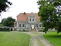
Manor house Kublank
Transport links
The federal motorway 20 runs through the community and can be reached via the Friedland-Woldegk junction (about five kilometers away). The railway line Neubrandenburg- Pasewalk crosses the municipality, the federal highway 104 runs south of the municipality.
literature
- The land of Stargard . In: Art and history monuments of the Free State of Mecklenburg-Strelitz . On behalf of the Ministry (Department of Education and Art). I. Volume, III. Department: The district court districts Friedland (2nd half), Stargard and Neubrandenburg - processed by Georg Krüger, Oberkirchenrat zu Neustrelitz. Commission publisher of the Brünslowsche Verlagsbuchhandlung (E. Brückner), Neubrandenburg 1929, District Court District Stargard - Kublank, p. 259 ff . ( online [accessed July 5, 2017]).
Web links
Individual evidence
- ↑ Statistisches Amt MV - population status of the districts, offices and municipalities 2019 (XLS file) (official population figures in the update of the 2011 census) ( help ).
- ↑ Reading version of the main statute of the municipality of Kublank from June 4th, 2009 in the version of the third amendment from December 9th, 2013. (PDF; 85 kB) Retrieved July 5, 2017 .
- ^ Art and historical monuments of the Free State of Mecklenburg-Strelitz. Volume 1: Georg Krüger: The Land of Stargard. Department 3: The Friedland District Court districts (2nd half). Stargard and Neubrandenburg. Brückner, Neubrandenburg 1929, p. 59.
- ^ Paul Kühnel: The Slavic place names in Meklenburg. In: Yearbooks of the Association for Mecklenburg History and Archeology. Vol. 46, 1881, ISSN 0259-7772 , pp. 3-168, here p. 77.
- ↑ main statute § 3
Alt Schwerin | Altenhagen | Altenhof | Altentreptow | Ankershagen | Bartow | Basedow | Beggerow | Ownership | Blankenhof | Blankensee | Flower wood | Bollewick | Borrentine | Bredenfelde | Breesen | Breest | Briggow | Brunn | Buchholz | Stargard Castle | Burow | Bütow | Carpin | Cölpin | Dargun | Datzetal | Demmin | Eldetal | Rotten rust | Feldberger Seenlandschaft | Fincken | Friedland | Five lakes | Galenbeck | Gielow | Gnevkow | Godendorf | Goehren-Lebbin | Golchen | Gotthun | Grabowhöfe | Grammentin | Grapzow | Grischow | Large trowel | Groß Miltzow | Gross Nemerow | Large plastic | Groß Teetzleben | Grünow | Validity | Gülzow | High Wangelin | Hohenbollentin | Hohenmocker | Hohenzieritz | Holldorf | Ivenack | Jabel | Jürgenstorf | Kargow | Kentzlin | Kieve | Kittendorf | Little Thank You | Kletzin | Klink | Klocksin | Knorrendorf | Kratzeburg | Kriesow | Sublank | Kuckssee | Kummerow | Larz | Leizen | Lindenberg | Lindetal | Malchin | Malchow | Meesiger | Melz | Mirow | Möllenbeck | Möllenhagen | Mölln | Moltzow | Neddemin | Neetzka | Neubrandenburg | Neuenkirchen | Recalculation | Neustrelitz | Neverin | Nossendorf | Nossentiner Hut | Peenehagen | Penkow | Penzlin | Pragsdorf | Priborn | Priepert | Pripsleben | Rechlin | Ritzerow | Röbel / Müritz | Röckwitz | Rosenow | Sarov | Schloen-Dratow | Schönbeck | Schönfeld | Schönhausen | Black | Siedenbollentin | Siedenbrünzow | Sietow | Silz | Sommersdorf | Sponholz | Staven | Stavenhagen | Steer | Südmüritz | Torgelow am See | Trollenhagen | Tützpatz | Userin | Utzedel | Forgive | Voigtsdorf | Vollrathsruhe | Walow | Waren (Müritz) | Warrenzin | Werder | Wesenberg | Wildberg | Woggersin | Wokuhl-Dabelow | Wolde | Woldegk | Wulkenzin | Wustrow | Zettemin | Zirzow | Zislow