Datzetal
| coat of arms | Germany map | |
|---|---|---|

|
Coordinates: 53 ° 40 ′ N , 13 ° 29 ′ E |
|
| Basic data | ||
| State : | Mecklenburg-Western Pomerania | |
| County : | Mecklenburg Lake District | |
| Office : | Friedland | |
| Height : | 31 m above sea level NHN | |
| Area : | 41.07 km 2 | |
| Residents: | 851 (Dec. 31, 2019) | |
| Population density : | 21 inhabitants per km 2 | |
| Postal code : | 17099 | |
| Primaries : | 039601, 039606, 039608 | |
| License plate : | MSE, AT, DM, MC, MST, MÜR, NZ, RM, WRN | |
| Community key : | 13 0 71 028 | |
| Office administration address: | Riemannstrasse 42 17098 Friedland |
|
| Website : | ||
| Mayor : | Jan Umlauft | |
| Location of the municipality of Datzetal in the Mecklenburg Lake District | ||
Datzetal is a municipality in the east of the Mecklenburg Lake District in eastern Mecklenburg-Western Pomerania . It is administered by the Friedland Office , located in the Friedland City Administration.
geography
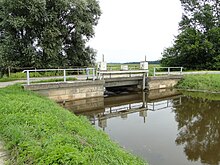
The community name, newly formed in 2003, indicates the location on both sides of the Datze , which runs in the glacial valley between Friedland and Neubrandenburg . The northern and western part of the municipality lies on the Werder , one up to 84 m above sea level. NN lying ground moraine , which has numerous small ponds and lakes without drainage.
Datzetal is surrounded by the neighboring communities Friedland in the north, east and south, Neuenkirchen and Staven in the south-west, Brunn in the west and Beseritz in the north-west.
Community structure
The community was formed on January 1, 2003 from the previously independent communities Sadelkow and Salow . In addition, the following districts belong to Datzetal: Bassow, Roga, Pleetz and Sadelkow settlement.
history
The community Datzetal was formed on January 1, 2003 from the formerly independent communities Sadelkow and Salow.
- History of the districts
Bassow was first mentioned in a document in 1397 and already belonged to Pleetz as a pertinence (ancillary estate) and as a fief of the Bertikow family. In the possession of the Hahn family since 1469 , Bassow was sold in the course of Hahn's great bankruptcy in 1815 and came into the possession of the bailiff (von) Michael in 1816, whose descendants owned Bassow until the land reform after 1945. The small classicist mansion burned down immediately after 1945 for unexplained reasons. Bassow has been part of the Datzetal community since 2003.
Pleetz: The former castle in Pleetz on the trade route from Neubrandenburg to Friedland was first mentioned in 1366 and was a knight's seat in the middle of the 14th century. In the early modern period , a manor was built on the castle grounds. It was owned by the von Bertikow family and since 1469 the (von) Hahn family . The preserved, unrenovated manor house was built as a half-timbered house at the beginning of the 18th century, the two-and-a-half-story half-timbered extension in the late 19th century.
Pleetz was a politically most important estate in the Mecklenburg southeast. As landowners, the Hahns acquired the hereditary office of Land Marshal of the Stargard lordship, which was connected with Pleetz in 1469 . Hereditary land marshal was one of the highest-ranking political honorary posts in the old Mecklenburg state, where there were always three hereditary land marshals (Mecklenburg, Wenden, Stargard) at the same time. The office connected with Pleetz had a von Hahn for 450 years until 1918 . Pleetz has been part of the Datzetal community since 2003.
Roga was first mentioned in a document in 1366. In 1415 the village was the seat of a Schulzenamt. In the early modern period, Roga first belonged to the Basedow family , then, from 1608 until the 19th century, to the Basedow-Hahn line . The caretaker's house dates from 1890. At the beginning of the 1830s, Roga had 229 residents. A remarkable Renaissance pulpit has been preserved
in the Romanesque village church of Roga from the second half of the 13th century, to whose parish Bassow also belonged .
Sadelkow first appears in a document in 1380. The place or parts of it had many owners since the Middle Ages and served numerous foundations. In the 16th century the Gentzkow and the Ihlenfeld owned the main part of the estate, later the Ahrenstorff, from 1912 the Lowtzow owners. The single-storey manor house dates from the first half of the 18th century.
On the land located southeast above the village in the Datze valley , 15 hereditary farms were set up on both sides of a new road, the so-called settlement path, from 1936 due to the Reichserbhofgesetz . They were mostly given to second or third farmer sons. Sadelkow has been part of the Datzetal community since 2003.
Salow was first mentioned in a document in 1385. The field stone church as the oldest building dates from 1308. The half-timbered church tower with a pointed helmet was demolished in 1968 due to dilapidation. For the purpose of rebuilding the tower, the Salower church tower association was founded in 2008 ; the estimated costs of 300,000 euros are to be raised primarily through donations.
The place and estate was owned by the Bertikow family in the 14th to 15th centuries. The property then changed hands. The main part of Salow belonging to Gut Pleetz belonged to the von Hahn family from 1469. After their bankruptcy, it was acquired by the chief captain Wilhelm von Oertzen in 1815 . Around 1800 the last farm positions in Salow had been opened up. Older parts of the manor house date from the end of the 18th century, the younger, two-storey extension from 1892.
After 1990, the streets and sidewalks as well as many house facades were renewed on their own initiative and with funding programs. The Salow village center with the community center, a youth club and a restaurant as well as a ceramic workshop and the home parlor was built in the former manor house. In 1998 and 2003 Salow was named the most beautiful village in the Mecklenburg-Strelitz district.
politics
coat of arms
|
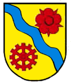
Blazon : "In gold, a blue waved thread, accompanied: above by a red rose, below by a six-spoke, twelve-blade red mill wheel."
The coat of arms and the flag were designed by Heinz Kippnick from Schwerin . It was approved together with the flag on August 14, 2003 by the Ministry of the Interior and registered under No. 283 of the coat of arms of the state of Mecklenburg-Western Pomerania. |
|
| Justification of the coat of arms: In the coat of arms, the position of the municipality on the Datze is symbolized with the oblique thread. The red rose is borrowed from the von Bertikow family coat of arms. It is intended to commemorate this family, who shaped the development of goods for a long time. The mill wheel stands for the watermills documented in the Datzeniederung in Roga and Pleetz. In addition, with the rose and the mill wheel, the coat of arms of the former municipality of Salow, which was valid until December 31, 2002, is linked. The tinging of the coat of arms indicates that the municipality belongs to the state of Mecklenburg. |
flag
The flag is striped in yellow, blue and yellow across the longitudinal axis of the flag cloth. The yellow stripes each take up a quarter, the blue stripe takes up half the length of the flag cloth. In the middle of the blue stripe is the municipal coat of arms, which takes up two thirds of the height of the flag. The length of the flag is related to the height as 5: 3. The city does not have an officially approved flag .
Official seal
The official seal shows the municipal coat of arms with the inscription "* GEMEINDE DATZETAL * LANDKREIS MECKLENBURGISCHE SEENPLATTE".
Attractions
- Village church in Bassow (PICTURES) , plastered half-timbered building from the 18th century.
- Pleetz manor from the 18th century
- Pleetz castle wall , Slavic castle wall from the 8th / 9th / 9th centuries century
- Village church in Roga (PICTURES) , field stone building from the 13th century
- Village church in Sadelkow (PICTURES) , field stone building from the 16th century, renovated with brick in 1866–1870
- Village church in Salow (PICTURES) , field stone building, 2nd half 13.8./9. century
- Datzetal cultural and meeting place in the Salow warehouse
- Neubauer houses in Salow
Economy and Transport
The main line of business in the municipality of Datzetal is still agriculture. There are also small businesses in the automotive and agricultural machinery service, electrical installation and wood processing businesses. In the vicinity of Salow there are abundant clay deposits that seem possible to mine in the future. In addition, there are two ceramic yards and three farms in Pleetz that provide jobs for the local population.
On the railway line Neubrandenburg Friedland where the breakpoint Pleetz was that was SPNV on 14 January 1994 set. The district Sadelkow is on the B 197 ( Neubrandenburg - Anklam ). The A 20 passes just a few kilometers south of Datzetal ( Neubrandenburg-Ost junction ). The nearest train station is in the town of Neubrandenburg, around 15 kilometers away.
Personalities
- Erich Tesch (1902–1967), fatality on the inner-German border
Web links
Individual evidence
- ↑ Statistisches Amt MV - population status of the districts, offices and municipalities 2019 (XLS file) (official population figures in the update of the 2011 census) ( help ).
- ↑ Area changes 2003 (PDF; 27 kB), State Statistical Office
- ^ Sabine Bock : Stately houses on the estates and domains in Mecklenburg-Strelitz. Architecture and history. (= Contributions to the history of architecture and preservation of monuments, 7.1–3), Thomas Helms Verlag , Schwerin 2008, ISBN 978-3-935749-05-3 , Volume 1, pp. 49–54.
- ^ Sabine Bock: Stately houses on the estates and domains in Mecklenburg-Strelitz. Architecture and history. (= Contributions to the history of architecture and the preservation of monuments, 7.1–3), Thomas Helms Verlag, Schwerin 2008, ISBN 978-3-935749-05-3 , Volume 2, pp. 702–707.
- ^ Franz Christian Boll : History of the Land of Stargard up to the year 1471, with documents and regesta , vol. 2. Hofbuchhandlung von G. Barnewitz, Neustrelitz 1847, p. 280, document no. 175.
- ^ Franz Christian Boll: History of the Land of Stargard up to 1471 , Vol. 2. Neustrelitz 1847, p. 363.
- ^ Georg Christian Friedrich Lisch : History and documents of the Hahn family , Vol. 2, Stillersche Hofbuchhandlung, Schwerin 1849, p. 169.
- ^ Gustav Hempel: Geographical-statistical-historical manual of the Mecklenburg country , part 1: General historical-geographical description . Edmund Frege, Güstrow 1837, p. 483.
- ^ Sabine Bock: Stately houses on the estates and domains in Mecklenburg-Strelitz. Architecture and history. (= Contributions to the history of architecture and preservation of monuments, 7.1–3), Thomas Helms Verlag, Schwerin 2008, ISBN 978-3-935749-05-3 , Volume 2, pp. 815–818.
- ^ Sabine Bock: Stately houses on the estates and domains in Mecklenburg-Strelitz. sArchitecture and history. (= Contributions to the history of architecture and the preservation of monuments, 7.1–3), Thomas Helms Verlag, Schwerin 2008, ISBN 978-3-935749-05-3 , Volume 2, pp. 819–824.
- ↑ Hans-Heinz Schütt: On shield and flag production office TINUS, Schwerin 2011, ISBN 978-3-9814380-0-0 , p. 294/295.
- ↑ a b main statute § 1 (PDF).
- ↑ http://www.kirche-alt-kaebelich-warlin.de/k-bassow.html
- ↑ http://www.speicher-salow.de/


