
Wolde
| coat of arms | Germany map | |
|---|---|---|

|
Coordinates: 53 ° 41 ′ N , 13 ° 5 ′ E |
|
| Basic data | ||
| State : | Mecklenburg-Western Pomerania | |
| County : | Mecklenburg Lake District | |
| Office : | Treptower Tollensewinkel | |
| Height : | 49 m above sea level NHN | |
| Area : | 22.51 km 2 | |
| Residents: | 537 (Dec. 31, 2019) | |
| Population density : | 24 inhabitants per km 2 | |
| Postal code : | 17091 | |
| Primaries : | 039600, 039604 | |
| License plate : | MSE, AT, DM, MC, MST, MÜR, NZ, RM, WRN | |
| Community key : | 13 0 71 163 | |
| Community structure: | 5 districts | |
| Office administration address: | Rathausstrasse 1 17087 Altentreptow |
|
| Website : | ||
| Mayoress : | Marion Dorn | |
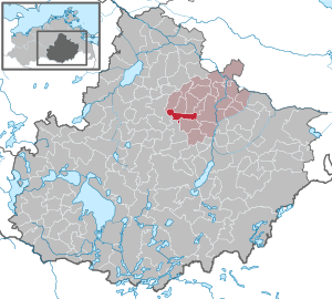
| Location of the community Wolde in the Mecklenburg Lake District | ||
  |
||

Wolde is a municipality in the center of the Mecklenburg Lake District . It is located east of Stavenhagen and is part of the Treptower Tollensewinkel office with its seat in Altentreptow .
Geography and traffic
Wolde is located on state road 273 about 14 kilometers west of Altentreptow and twelve kilometers east of Stavenhagen . The federal highway 104 runs south of the community. Wolde can be reached via the Altentreptow connection on federal motorway 20 .
Districts
- Japzow (merger on January 1, 1960 with Zwiedorf zu Wolde)
- Reinberg (incorporated on September 30, 1998)
- Schmiedenfelde
- Wolde
- Zwiedorf (merger on January 1, 1960 with Japzow zu Wolde)
history
Until January 1, 2005, the community was part of the Kastorfer See office .
Wolde as well as Wolde Castle are of Slavic origin. The place was first mentioned in a document in 1292. A knight Heinrich in Wolde is said to have founded the place. The castle was destroyed in 1481 by Duke Magnus II of Mecklenburg . The village and Wolde Castle were exactly on the border between Mecklenburg and Pomerania, and the dukes of both countries thus claimed sovereignty over the place. There is said to have been a small customs house in Wolde, through the middle of which the border between the two countries ran. The landowners at the time also played the two liege lords off against each other. In 1873 a state treaty was signed between Mecklenburg and Prussia. This determined what share both countries should get in the village. The castle, church and farm yard now belonged to Mecklenburg, the rest, the mostly smaller houses, to Prussia.
The estate was successively owned by the von Winterfeld families in the 14th century, von Preen since 1569, von Maltzahn from 1646, von Burkersroda from 1770, von Moltke , again von Maltzahn, von Fabrice from 1850 and finally shortly afterwards von Heyden-Linden who kept it until the end of World War II.
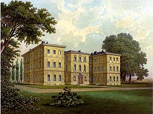
In 1797 Bogislav Helmut von Maltzahn had a massive mansion built. Inside the two-wing complex there was a large hall of mirrors and one wing had its own chapel. There was also a stables, other farm buildings, a large fruit and vegetable garden with greenhouses and an extensive English landscape park. The castle was demolished in 1945. A smaller manor house was built in the middle of the 19th century as an inspector's house on behalf of Baron von Fabrice. This inhabited manor house is now owned by the municipality.
Schmiedenfelde: The approx. 300 hectare estate was created in 1835 when the economist Schmiede merged two Reinberg farms and a parcel of the state forest. The renovated manor house dates from the 19th century.
politics
Coat of arms, flag, official seal
The municipality has no officially approved national emblem, neither a coat of arms nor a flag . The official seal is the small state seal with the coat of arms of the region of Western Pomerania . It shows an upright griffin with a raised tail and the inscription "GEMEINDE WOLDE • LANDKREIS MECKLENBURGISCHE SEENPLATTE".
Attractions
- The so-called Gutshaus Wolde was built in the 19th century as an inspector's house
- Wolde estate
- Landscape Park Wolde with Kastanienallee
- Castle hill Wolde with moat and castle hill
- Wolde Church (built in 1859/1860) on the former castle complex
- Tower hill "Kiekeberg" Wolde
- Wolde cemetery portal, brick
- Village churches in Zwiedorf, Japzow and Reinberg
- Memorials: Two graves of unknown Polish men in the cemetery , which during the Second World War, victims of forced labor were
- Attractions

Church on the Wolde Castle Hill
Wolde Castle around 1860, Alexander Duncker Collection (canceled in 1945)

Manor house (inspector house) in Wolde

Church in Zwiedorf


Personalities
Sons and daughters of the place
- Helmuth Dietrich von Maltzahn (1761–1826), Prussian major general, most recently Landwehr brigade commander
Connected to the place
- Bernd von Maltzan (before 1474–1525), also the evil Bernd , robber baron and ducal Mecklenburg Privy Councilor, owner of Wolde Castle
literature
- Wolde in: New Conversations Lexicon: State and Society Lexicon. In connection with German scholars and statesmen. ed. by Herrmann Wagener, Volume 22, 1866 (digitized version)
- Hubertus Neuschäffer: Western Pomerania's castles and mansions . Husum Druck- und Verlagsgesellschaft 1993, p. 212, ISBN 3-88042-636-8
Web links
- Literature about Wolde in the state bibliography MV
- Location Wolde at demminarchiv.de
- Wolde at www.orte-in-mv.de
Individual evidence
- ↑ Statistisches Amt MV - population status of the districts, offices and municipalities 2019 (XLS file) (official population figures in the update of the 2011 census) ( help ).
- ↑ a b Municipalities 1994 and their changes since January 1st, 1948 in the new federal states , Metzler-Poeschel publishing house, Stuttgart, 1995, ISBN 3-8246-0321-7 , publisher: Federal Statistical Office
- ^ StBA: Changes in the municipalities in Germany, see 1998
- ^ Castle and Gut Wolde at Gutshaeuser.de ( Memento from August 19, 2013 in the Internet Archive )
- ↑ Main Statute, Section 1, Paragraph 3 (PDF).
Alt Schwerin | Altenhagen | Altenhof | Altentreptow | Ankershagen | Bartow | Basedow | Beggerow | Ownership | Blankenhof | Blankensee | Flower wood | Bollewick | Borrentine | Bredenfelde | Breesen | Breest | Briggow | Brunn | Buchholz | Stargard Castle | Burow | Bütow | Carpin | Cölpin | Dargun | Datzetal | Demmin | Eldetal | Rotten rust | Feldberger Seenlandschaft | Fincken | Friedland | Five lakes | Galenbeck | Gielow | Gnevkow | Godendorf | Goehren-Lebbin | Golchen | Gotthun | Grabowhöfe | Grammentin | Grapzow | Grischow | Large trowel | Groß Miltzow | Gross Nemerow | Large plastic | Groß Teetzleben | Grünow | Validity | Gülzow | High Wangelin | Hohenbollentin | Hohenmocker | Hohenzieritz | Holldorf | Ivenack | Jabel | Jürgenstorf | Kargow | Kentzlin | Kieve | Kittendorf | Little Thank You | Kletzin | Klink | Klocksin | Knorrendorf | Kratzeburg | Kriesow | Sublank | Kuckssee | Kummerow | Larz | Leizen | Lindenberg | Lindetal | Malchin | Malchow | Meesiger | Melz | Mirow | Möllenbeck | Möllenhagen | Mölln | Moltzow | Neddemin | Neetzka | Neubrandenburg | Neuenkirchen | Recalculation | Neustrelitz | Neverin | Nossendorf | Nossentiner Hut | Peenehagen | Penkow | Penzlin | Pragsdorf | Priborn | Priepert | Pripsleben | Rechlin | Ritzerow | Röbel / Müritz | Röckwitz | Rosenow | Sarov | Schloen-Dratow | Schönbeck | Schönfeld | Schönhausen | Black | Siedenbollentin | Siedenbrünzow | Sietow | Silz | Sommersdorf | Sponholz | Staven | Stavenhagen | Steer | Südmüritz | Torgelow am See | Trollenhagen | Tützpatz | Userin | Utzedel | Forgive | Voigtsdorf | Vollrathsruhe | Walow | Waren (Müritz) | Warrenzin | Werder | Wesenberg | Wildberg | Woggersin | Wokuhl-Dabelow | Wolde | Woldegk | Wulkenzin | Wustrow | Zettemin | Zirzow | Zislow