
Käbelicksee
| Käbelicksee | ||
|---|---|---|

|
||
| Käbelicksee, Müritz National Park | ||
| Geographical location | District of Mecklenburg Lake District | |
| Tributaries | Havel | |
| Drain | Havel to the Granziner See | |
| Location close to the shore | Kratzeburg , Dalmsdorf | |
| Data | ||
| Coordinates | 53 ° 25 '2 " N , 12 ° 56' 33" E | |
|
||
| Altitude above sea level | 62.4 m above sea level NHN | |
| surface | 2.64 km² | |
| length | 2.51 km | |
| width | 1.508 km | |
| volume | 8,900,000 m³ | |
| Maximum depth | 12.6 m | |
| Middle deep | 3.4 m | |
| PH value | 8.2-8.7 | |
| Catchment area | 32.8 km² | |

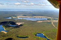
The Käbelicksee is a lake in the area of the municipality of Kratzeburg in the Mecklenburg Lake District in Mecklenburg-Western Pomerania . The lake is divided into a deeper, less indented north basin and a shallower, more indented south basin. Both basins are separated from each other by a larger peninsula. There are also two smaller islands in the south basin. The lake is about 2500 meters long and up to 1500 meters wide. On the north bank is the place Kratzeburg, on the west bank of the Kratzeburg district Dalmsdorf. There is a campsite on the eastern shore of the lake. The lake has very good water quality and is the starting point for water hikes in the Neustrelitz area.
Käbelicksee from the direction of S

See also
Web links
Commons : Käbelicksee - Collection of images, videos and audio files