Brohmer Mountains
| Brohmer Mountains | ||
|---|---|---|
|
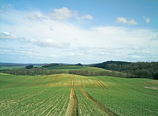
Brohmer Mountains on the Fuchsberg near Gehren |
||
| Highest peak | nameless elevation near Matzdorf ( 153.1 m above sea level ) | |
| location | Districts of Mecklenburg Lake District and Vorpommern-Greifswald , Mecklenburg-Vorpommern ( Germany ) | |
|
|
||
| Coordinates | 53 ° 35 ' N , 13 ° 40' E | |
| rock | Compression moraine from the Vistula Ice Age | |

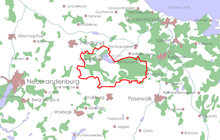
The Brohmer Mountains are one to 153.1 m above sea level. NHN high terminal moraines of around 6500 hectares in the districts of Mecklenburg Lake District and Western Pomerania-Greifswald in the southeast of the German state of Mecklenburg-Western Pomerania . They are named after the Friedland district Brohm ( Brohm or broma from the Slavic for "gate").
geography
location
The Brohmer Mountains extend east of the village Brohm between the cities of Friedland in the northwest and Strasburg in the southeast. In the west they reach to Schönbeck and in the east to Jatznick . The Helpter Mountains are just under 12 km south of the Brohmer Mountains, which are part of the Mecklenburg Ice Age Landscape Geopark .
Surveys

To the elevations of the mountains Brohm and their eastern environment (height in meters above include zero height ) loud, usually:
- nameless elevation (153.1 m) - about 1.2 km northwest of Matzdorf in the Ratteyer forest
- nameless survey ( Luderberg )? (133.3 m) - south-southwest of Klepelshagen
- Brohmer Berg (131 m) - about 2.5 km southeast of Brohm
- Römerberg (129.3 m) - northwest of Waldeshöhe
- Düntzelberg (128 m) - north of Matzdorf
- Schanzenberg (125.5 m) - northeast of Rosenthal in the NSG "Burgwall Rothemühl"
- nameless elevation (124.3 m) - in the Nettelgrund forest
- Fuchsberg (122.8 m) - east of Matzdorf
- Kaspers Berg (114.2 m) - west of Jatznick
- Ziegler Berg (113.3 m) - north-north-west of Rosenthal
- Splettberg (105.8 m) - west of Rosenthal
- Sauberg (105.6 m) - in the Nettelgrund forest
Waters
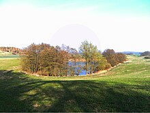
In the Brohmer Mountains there are numerous pools , moored valleys and a few small spring streams. In the west, the Golmer Mühlbach touches the area and at the northern foot of the Brohmer Mountains lies the Galenbeck lake. Other lakes on the edge of the Brohmer Mountains are the Brohmer Reservoir , the Schönhauser See , the Schmiedegrundsee , the Michaelssee and the Dementia Lake .
Localities
There are no closed living spaces in the wooded core area of the Brohmer Mountains . On the periphery of the area are the localities :
- Friedland - with the district Brohm
- Galenbeck - with the districts Friedrichshof , Rohrkrug and Wittenborn
- Jatznick - with the districts of Klein Luckow , Groß Spiegelberg and Waldeshöhe
- Rothemühl - with the residential areas extension and Nettelgrund
- Schönbeck - with the districts Charlottenhof and Rattey
- Schönhausen - with the district of Matzdorf
- Strasburg - with the districts of Gehren , Klepelshagen , Neuensund , Rosenthal and Schwarzensee
- Voigtsdorf
geology
The Brohmer Mountains were formed around 13,700 years ago as the upsetting moraine of the Rosenthaler Staffel, the main terminal moraine of the Mecklenburg stage of the Vistula glaciation . The glacier, coming from the north and only a few hundred meters high, pushed inland one last time. It was stopped by the mountain ranges that had already been shaped by earlier ice advances. The ice masses acted with enormous forces on the subsoil, so that parts of the Saale Ice Age sediments and even layers of the Tertiary were pushed up by more than 100 meters. Through these movements, the material lying in front of the ice edge was pushed together to form dams. The elevation, known as the Rosenthal compression moraine, is divided into two lobes , the Klepelshagen Lobus to the west and the Jatznicker Lobus to the east. Both praise meet at Rothemühl . In the depression between the Loben, east of the Schanzenberg, was the most important glacier gate of the Brohmer Mountains. The emerging meltwater created the channel in the foreland in which the dementia lake is located today . Other glacier gate tracks or gullies formed in front of them are only insignificantly pronounced within the Brohmer Mountains. Sandersands were only sporadically and sedimented in small amounts. The foreland of the Brohmer Mountains therefore consists mainly of remnants of older terminal moraines and ground moraine sediments from the Pomeranian stage of the Vistula glaciation. Since most of the glacier meltwater could not overcome the terminal moraine of the Brohmer Mountains, the Haffstausee formed in the backland of the moraine , whose sedimented basin sands characterize the Ueckermünder Heide today. In the western part of the hinterland, the muddy lowlands of the Friedland Great Meadow and the Galenbeck Lake were created in a glacier tongue basin .
The Rosenthaler Staffel is a model example for upsetting moraines in young moraines .
In the past, Eocene and Oligocene clays , especially high-quality Rupel clays , were mined near Jatznick . The pits are filled in today. Oligocene gravels are currently being mined here in small-scale opencast mines .
Flora and fauna
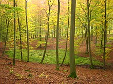
The Brohmer Mountains are almost completely forested. The main tree species is the common beech . Near-natural beech and mixed beech forests predominate with accompanying vegetation ( Milio-Fagetum ). Common mixed tree species are pine , sessile oak , hornbeam , sycamore maple and winter linden . Birch and black alder grow in muddy hollows .
Special features of the fauna in the Brohmer Mountains are the occurrence of stag beetles , wild goats , crested newts , red-bellied toads , great mouse ears and orioles . The main game species are red deer , black deer and roe deer .
Protected areas
The nature reserves Klepelshagen and Burgwall Rothemühl were established in the Brohmer Mountains . The landscape is part of the European bird sanctuary Brohmer Berge (4,129 ha) and the FFH area forest and small water landscape Brohmer Berge (5,209 ha). She is also part of the 18,600-hectare nature sanctuary Brohm Mountains .
Transport links
South of the Brohmer Mountains runs a section of the federal highway 20 , which touches the terminal moraine in the west-east direction. The ridge can be easily reached from the Friedland and Strasburg motorway junctions.
Web links
- Brohmer & Helpter Berge - Website of the "Brohmer & Helpter Berge Tourismusverein eV"
Individual evidence
- ↑ a b Geodata Viewer of the Office for Geoinformation, Surveying and Cadastral Affairs Mecklenburg-Western Pomerania ( notes )
- ^ In the footsteps of the Ice Age - Geopark Mecklenburg Ice Age Landscapes , Geoscientific Association Neubrandenburg e. V., 1st edition 2003 ISSN 1616-959X
- ↑ Brohmer Berge - Landschaftsbildpotenzial (analysis) (PDF; 8 kB), on Umweltkarten.mv
- ↑ Landscape protection areas in Mecklenburg-Western Pomerania , list dated December 31, 2015 (PDF; 17 kB), on mv-regierung.de


