
Eichhorst (Friedland)
|
Eichhorst
City of Friedland
Coordinates: 53 ° 35 '43 " N , 13 ° 29' 53" E
|
||
|---|---|---|
| Height : | 62 m above sea level NHN | |
| Area : | 28.31 km² | |
| Residents : | 474 (Dec. 31, 2012) | |
| Population density : | 17 inhabitants / km² | |
| Incorporation : | May 25, 2014 | |
| Postal code : | 17099 | |
| Area code : | 039606 | |
Location of Eichhorst in Mecklenburg-Western Pomerania |
||

Eichhorst is a district of the city of Friedland in the Mecklenburg Lake District in eastern Mecklenburg-Western Pomerania .
geography
The local area lies on a ground moraine east of the Datze glacial valley, about eight kilometers south of the city of Friedland and 18 kilometers east of Neubrandenburg . Eichhorst is surrounded by three small lakes - towards the south the number of lakes gradually increases (Feldberger and Uckermark Lake District). To the east and south, the area rises to over 150 m above sea level. NN ( Brohmer Mountains and Helpter Mountains ).
The places Jatzke (incorporated on January 1, 2001) and Liepen (incorporated on January 1, 1973) belong to Eichhorst.
history

Continuous settlement of the districts in the Eichhorst area since the Neolithic Age can be proven on the basis of a number of prehistoric and early historical sites. The most important archaeological monument is, in addition to some heavily leveled Bronze Age barrows, a Slavic rampart on the outskirts of Jatzke. The " stone box " on the south side of the castle ramparts is a replica of a stone age grave and dates from the 19th century.
In 1298 the village, which was laid out as an anger village , was first mentioned as Eykchorst . The name is probably due to the large oak forests between the Datzetal and the Brohmer Mountains at the time.
In the Thirty Years' War also Eichhorst was completely destroyed.
Eichhorst has belonged to Mecklenburg-Strelitz since 1701 .
The current form of the Eichhorster Feldsteinkirche emerged after renovation work in 1837. The manor house was built on the basis of older predecessor buildings in 1821 in a classical style. Until the expropriation in 1945, the landowners changed several times, including Bredow , Engel and Schwerin . From 1964 to 1990 the manor house was partially used as a school. The building, which is in dire need of renovation, has not found a new owner since then.
Due to the area change agreement between the city of Friedland and the municipality of Eichhorst of December 12, 2013, Eichhorst and its districts were incorporated into Friedland on May 25, 2014.
Attractions
- Field stone church in Eichhorst
- Field stone church in Jatzke
- Gothic brick church in Liepen
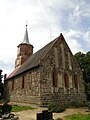
Church in Eichhorst

Manor house in Eichhorst

Church in Liepen


Economy and Infrastructure
After reunification, the former LPG became an agricultural cooperative. Some farmers ( resettlers ) also cultivate the fields in the area.
Transport links
There is a connection to the national trunk road network ( Bundesstrasse 197 and Bundesautobahn 20 ). The nearest train station is in Sponholz, about 15 kilometers away (route Neubrandenburg - Pasewalk - Stettin ).
Personalities
- Christoph August von Bredow (1780–1844), Prussian landowner
- Friedrich Kortüm (1788–1858), historian, professor of history in Bern and Heidelberg
literature
- The land of Stargard . In: Art and history monuments of the Free State of Mecklenburg-Strelitz . On behalf of the Ministry (Department of Education and Art). I. Volume, III. Department: The district court districts Friedland (2nd half), Stargard and Neubrandenburg - processed by Georg Krüger, Oberkirchenrat zu Neustrelitz. Commission publisher of the Brünslowschen Verlagbuchhandlung (E. Brückner), Neubrandenburg 1929, Friedland - Eichhorst district court, p. 3 ff . ( online [accessed August 12, 2018]).
Web links
Individual evidence
- ↑ StBA: Changes in the municipalities in Germany, see 2001
- ↑ Municipalities 1994 and their changes since January 1, 1948 in the new federal states , Metzler-Poeschel publishing house, Stuttgart, 1995, ISBN 3-8246-0321-7 , publisher: Federal Statistical Office
- ^ Sabine Bock : Stately houses on the estates and domains in Mecklenburg-Strelitz. Architecture and history. Volume 1. (= contributions to the history of architecture and monument preservation, 7.1–3). Thomas Helms Verlag Schwerin 2008, ISBN 978-3-935749-05-3 , pp. 224-228.
- ^ Statistical Office Mecklenburg-Western Pomerania: Area changes

Bresewitz | Brohm | Cosa | Dishley | Eichhorst | Friedland (core town) | Gentskow | Glienke | Heinrichswalde | Hohenstein | Jatzke | Liepen | Ramelow | Schwanbeck