Müritzarm
| Müritzarm | ||
|---|---|---|

|
||
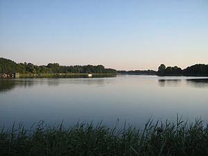
| Müritzarm near Vipperow | ||
| Geographical location | District of Mecklenburg Lake District | |
| Tributaries | Transition to Müritzsee ( Elde ) | |
| Drain | Transition to the Kleine Müritz (Elde) | |
| Places on the shore | Vipperow , Gaarzer Mühle | |
| Location close to the shore | Priborn | |
| Data | ||
| Coordinates | 53 ° 18 '51 " N , 12 ° 41' 8" E | |
|
|
||
| Altitude above sea level | 62.1 m above sea level NHN | |
| surface | 1.23 km² | |
The Müritzarm is a lake in the municipality of Priborn in the Mecklenburg Lake District . It is part of the chain of lakes that adjoins the Müritz to the south . The poorly structured, river-like lake is between 250 and 300 meters wide and a little over 3.9 kilometers long. In the south the water flows into the Müritzsee . To the north, the lake is separated from the Kleine Müritz by a dam with a small bridge . The federal highway 198 leads over the dam . The bank is flat and is mostly used for agriculture in the wider area. In the northwest, the place Vipperow borders on the lake.
See also
Web links
Commons : Müritzarm - Collection of images, videos and audio files
