
Dosse
| Dosse | ||
 Position of the cans |
||
| Data | ||
| Water code | EN : 5892 | |
| location | northeastern Germany : Brandenburg , Saxony-Anhalt | |
| River system | Elbe | |
| Drain over | Havel → Elbe → North Sea | |
| source | northeast of Meyenburg 53 ° 19 ′ 39 ″ N , 12 ° 16 ′ 51 ″ E |
|
| Source height | approx. 85 m above sea level NHN | |
| muzzle |
Havel near Havelberg Coordinates: 52 ° 47 ′ 42 " N , 12 ° 12 ′ 45" E 52 ° 47 ′ 42 " N , 12 ° 12 ′ 45" E
|
|
| length | 96 km | |
| Catchment area | 1268 km² | |
| Discharge at the Wusterhausen A Eo gauge: 699.52 km² Location: 25.9 km above the mouth |
NNQ (10/14/1992) MNQ 1995/2005 MQ 1995/2005 Mq 1995/2005 MHQ 1995/2005 HHQ (03/19/1970) |
300 l / s 1.36 m³ / s 3.18 m³ / s 4.5 l / (s km²) 7.93 m³ / s 17.5 m³ / s |
| Small towns | Wittstock / Dosse , Wusterhausen / Dosse | |
The Dosse is a right tributary of the Havel . It is 96 km long and has a catchment area of 1268 km².
Surname
The name Dosse is of Indo-European origin and belongs to the oldest European name layer. The root of the word indicates * dhü- or * dheu "swirl". The name of the Slavic tribe of the Dossans (Doxani, Doxanen, Dasseri, Desseri), who settled on the Dosselauf in the 10th century, is derived from the river name .
course
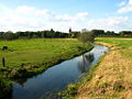
The Dosse rises in the border area of Mecklenburg-Western Pomerania and the State of Brandenburg on a plateau on the northern edge of the Prignitz , about three kilometers northeast of Meyenburg . This plateau lies between Wendisch Priborn and Meyenburg. The source areas of the Elde and Stepenitz are not far from the Dosquelle . In this area, further small brooks arise, which flow into the Dosse every four kilometers. The Dosse initially flows in a south-easterly direction and forms the border between Mecklenburg-Western Pomerania and Brandenburg to the north and east of Freyenstein . Approximately at the crossing under the A 19 autobahn , the Dosse turns to the south and flows over Wittstock / Dosse and Wusterhausen / Dosse through the Doss lowlands to Neustadt (Dosse) . Approx. 12 kilometers south of Neustadt (Dosse), at Großderschau , the Dosse reaches the lowlands of the Berlin glacial valley , in which it continues to flow in a westerly direction. About five kilometers north of the Gülper See , which it does not flow through, the Dosse flows into the Havel at Vehlgast-Kümmernitz .
use
In the Middle Ages, the lower Dosse, from the mouth to at least Wusterhausen / Dosse, was an important traffic route, over which wood (downstream) and salt (upstream) were transported by ship.
From 1850 the river was floodable from the village of Dosse and from Hohenofen , about 18 kilometers from the Havel, it was navigable for smaller vehicles at any time. The printed shipping guide from 1940 describes it as moderately navigable as far as Rübehorst . In its lower reaches, the Dosse is still navigable today up to the bridge at Rübehorst . The Dossespeicher Kyritz is located on a tributary in its catchment area .
photos
Dosse at Wittstock

Dossewehr in Wittstock


literature
- Hans Joachim Uhlemann: Berlin and the Märkische waterways. transpress, Berlin 1988, ISBN 3-344-00115-9 , p. 175.
Individual evidence
- ^ Wusterhausen gauge , State Office for the Environment, Health and Consumer Protection (LUGV) Brandenburg
- ↑ Manfred Niemeyer (ed.), German book of local names (Berlin 2012) p. 444.
- ^ Sascha Bütow: Streets in the river. Shipping, river use and the long changes in the transport infrastructure in the Mark Brandenburg and Niederlausitz from the 13th to the 16th century , Berlin 2015 (p. 223–226)
- ↑ What is meant is the village of Dossow , sometimes spelled Dosso in German , today a district of Wittstock / Dosse