
Siggelkow
| coat of arms | Germany map | |
|---|---|---|

|
Coordinates: 53 ° 23 ' N , 11 ° 56' E |
|
| Basic data | ||
| State : | Mecklenburg-Western Pomerania | |
| County : | Ludwigslust-Parchim | |
| Office : | Eldenburg Luebz | |
| Height : | 53 m above sea level NHN | |
| Area : | 54.97 km 2 | |
| Residents: | 845 (Dec. 31, 2019) | |
| Population density : | 15 inhabitants per km 2 | |
| Postal code : | 19376 | |
| Area code : | 038724 | |
| License plate : | LUP, HGN, LBZ, LWL, PCH, STB | |
| Community key : | 13 0 76 125 | |
| Community structure: | 5 districts | |
| Address of the municipal administration: |
Ringstrasse 1 19376 Marnitz branch office |
|
| Website : | ||
| Mayoress : | Sigrid Mohr | |
| Location of the municipality of Siggelkow in the Ludwigslust-Parchim district | ||
  |
||

Siggelkow is a municipality in the southeast of the Ludwigslust-Parchim district in Mecklenburg-Western Pomerania (Germany). It is administered by the Amt Eldenburg Lübz , based in the city of Lübz .
Geography and traffic

The community is located in the lowlands of the Elde, about eight kilometers southeast of Parchim and about ten kilometers south of Lübz . The Müritz-Elde waterway and an old arm of the Elde , into which the Gehlsbach and Moosterbach flow, flow on the northern border of the municipality . Standing waters are the Sabelsee and the Blanksee . Siggelkow is rich in nature reserves, such as the Wüstemoor nature reserve at Blanksee , the Gehlsbachtal nature reserve near Klein Pankow and the Sabelsee nature reserve near Groß Pankow. Larger forest areas in the municipality are the Siggelkower Tannen in the west, the Pankower Tannen in the south and the small forest area around the highest point of the municipality, the Heideberg at 77.3 m above sea level. NHN , at Redlin.
The federal motorway 24 , which can be reached via the Suckow junction, runs south of the municipality .
Districts
Districts of the community are Groß Pankow, Klein Pankow, Neuburg, Redlin and Siggelkow.
history
The districts of the municipality are of Slavic origin. In 1235 Siggelkow was first mentioned as Siklecowe . This is followed by Redlin 1307, Klein Pankow 1364, Groß Pankow 1396 and Neuburg 1451. The area was always in the border area between Mecklenburg and Brandenburg . From the 13th century until 1452 the area belonged to the Dünamünde monastery (today Daugavgriva) in Latvia and then to the Templin monastery . After that the country belongs to Mecklenburg-Schwerin except for Redlin . After the Second World War and the founding of the GDR , Siggelkow and the village of Redlin came first to the state of Mecklenburg and then to the Schwerin district .
On January 1, 1951, the previously independent community of Groß Pankow was incorporated.
Since the fall of the Wall in 1990, Siggelkow has belonged to the state of Mecklenburg-Western Pomerania and from July 1, 2004 to the Eldenburg Lübz office.
The name of Siggelkow comes from the Old Slavic žih and indicates the Slavic locator , i.e. place of Žichlik .
Pankow was also named after the locator, the place of the Pąk .
politics
coat of arms
|
|
Blazon : “In gold, a slanted blue wavy strip, accompanied: at the top by a red owl sitting on a black branch; at the bottom of a red urn with two handles profiled in the bulbous center. "
The coat of arms and the flag were designed by the Schwerin heraldist Karl-Heinz Steinbruch . It was approved on March 2, 2001 by the Ministry of the Interior and registered under the number 238 of the coat of arms of the state of Mecklenburg-Western Pomerania. |
| Justification for the coat of arms: In the coat of arms, the wavy bar symbolizes the Moosterbach flowing through the communal corridor. With the owl, the relation to nature conservation, in particular the importance of intact nature, as an economic factor - tourism - should be emphasized for the community. The urn refers to the numerous prehistoric and early historical excavation finds in the community hallway. |
flag

The flag was approved by the Ministry of the Interior on October 24, 2001.
The flag is striped lengthways in blue, yellow and blue. The blue stripes each take four ninths, the yellow stripe one ninth the height of the flag cloth. In the middle of the yellow stripe, at five eighths of the height of the two blue stripes, is the municipal coat of arms. The length of the flag is related to the height as 5: 3.
Official seal
The official seal shows the municipal coat of arms with the inscription "GEMEINDE SIGGELKOW".
Attractions
→ See also the list of architectural monuments in Siggelkow
- neo-Gothic church in Redlin from 1876
- Village church in Groß Pankow from 1705; simple single - nave half-timbered building with boarded west tower; the small winged altar is late Gothic with a shrine from after 1530/40
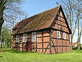
- Half-timbered church in Siggelkow from probably the 18th century with a low, boarded-up west tower
- Half-timbered church in Klein Pankow from 1650
- Memorial stone from 1950 behind the Eldebrücke in the direction of Parchim in memory of the victims of the death march of the inmates of the Sachsenhausen concentration camp and the Heinkel-Werk satellite camp , with a memorial plaque since 1976
- Memorial stone from the beginning of the 1950s on Meyenburger Strasse in the Redlin district in memory of the victims of the death march
- Memorial stone from 1950 in the center of the village of Siggelkow to the concentration camp prisoners of the death march, plus an information board from 1976

Village church in Siggelkow

Village church in Groß Pankow

Village church in Redlin
Village church in Klein Pankow


Web links
Individual evidence
- ↑ Statistisches Amt MV - population status of the districts, offices and municipalities 2019 (XLS file) (official population figures in the update of the 2011 census) ( help ).
- ↑ § 2 of the main statute (PDF; 20 kB) of the municipality
- ^ Paul Kühnel: The Slavic place names in Meklenburg. In: Yearbooks of the Association for Mecklenburg History and Archeology. Vol. 46, 1881, ISSN 0259-7772 , pp. 3-168, here p. 134.
- ^ Paul Kühnel: The Slavic place names in Meklenburg. In: Yearbooks of the Association for Mecklenburg History and Archeology. Vol. 46, 1881, pp. 3–168, here p. 102.
- ↑ Hans-Heinz Schütt: On shield and flag - the coats of arms and flags of the state of Mecklenburg-Western Pomerania and its municipalities . Ed .: production office TINUS; Schwerin. 2011, ISBN 978-3-9814380-0-0 , pp. 207/208 .
- ↑ a b main statute § 1 (PDF).

Alt Krenzlin | Old Zachun | Balow | Bandenitz | Banzkow | Barkhagen | Barnin | Belsch | Bengerstorf | Possession | Blankenberg | Blievenstorf | Bobzin | Boizenburg / Elbe | Borkow | Brahlstorf | Brenz | Bresegard at Eldena | Bresegard near Picher | Bruel | Brunow | Bülow | Cambs | Crivitz | Dabel | Dambeck | Demes | Dersenow | Dobbertin | Dobin at the lake | Dömitz | Domsühl | Dumber | Eldena | Friedrichsruhe | Gallin | Gallin Cupcentess | Gammelin | Ganzlin | Gehlsbach | Gneven | Göhlen | Goldberg | Gorlose | Grabow | Granzin | Grebs-Niendorf | Greetings | Greven | Great Godems | Big stuff | Groß Laasch | Hagenow | Hohen Pritz | Holthusen | Hoort | Hülseburg | Parental leave | Karrenzin | Karstädt | Church of Jesar | Klein Rogahn | Tempzin Monastery | Kobrow | Kogel | Circling | Kremmin | Kritzow | Kuhlen-Wendorf | Cow peat | Langen Brütz | Leezen | Lewitzrand | Luebesse | Lueblow | Lübheen | Luebz | Ludwigslust | Lüttow-Valluhn | Malk Göhren | Malliss | Mestlin | Milow | Möllenbeck | Moraas | Muchow | Mustin | New Gülze | New Kaliss | New Poserin | Neustadt-Glewe | Nostorf | Upper Warnow | Pampow | Parchim | Passow | Pätow-Steegen | Picher | Pinnow | Plate | Plau am See | Prislich | Pritzier | Raben Steinfeld | Rastow | Redefin | Rome | Ruhner Mountains | Lap in | Schwanheide | Siggelkow | Spornitz | Sternberg | Stumble | Stralendorf | Straw churches | Sukow | Sülstorf | Techentin | Teldau | Ticino | Toddin | Tramm | Uelitz | Vellahn | Vielank | Warlitz | Warlow | Warsow | Weitendorf | Werder | Wittenburg | Wittendbod | Wittenförden | Witch | Wöbbelin | Zapel | Zarrentin am Schaalsee | Ziegendorf | Zierzow | Zölkow | Zulow