
Brunow
| coat of arms | Germany map | |
|---|---|---|

|
Coordinates: 53 ° 16 ' N , 11 ° 48' E |
|
| Basic data | ||
| State : | Mecklenburg-Western Pomerania | |
| County : | Ludwigslust-Parchim | |
| Office : | Grabow | |
| Height : | 35 m above sea level NHN | |
| Area : | 21.09 km 2 | |
| Residents: | 296 (Dec. 31, 2019) | |
| Population density : | 14 inhabitants per km 2 | |
| Postcodes : | 19372, 19357 (Klüß) |
|
| Area code : | 038721 | |
| License plate : | LUP, HGN, LBZ, LWL, PCH, STB | |
| Community key : | 13 0 76 021 | |
| Community structure: | 3 districts | |
| Office administration address: | Berliner Strasse 8a 19297 Grabow |
|
| Website : | ||
| Mayoress : | Heike Bartczak | |
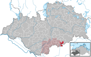
| Location of the municipality of Brunow in the Ludwigslust-Parchim district | ||
  |
||

Brunow is a municipality in the Ludwigslust-Parchim district in Mecklenburg-Western Pomerania, Germany. It is administered by the Grabow office based in Grabow .
The districts Bauerkuhl, Klüß and Löcknitz belong to the community.
geography
Brunow is a municipality in the Ludwigslust-Parchim district , borders the state of Brandenburg in the south and is located in the sparsely populated area southwest of the Ruhner Mountains .
In the aerial photographs in Brunow one discovers distinctive features of a rural village . Houses and farmsteads are arranged in a star shape around a central village square with a church. In contrast, the district of Klüß is a typical street village .
history
The construction of Brunow suggests a Wendish round square village from the 12th century. The first documentary mention of a land sale comes from the year 1340. After the loss-making Thirty Years War , farmers settled again. The history of the place is connected with that of Dambeck until the 18th century , as Brunow was part of the main Dambeck estate until then. Then it passed into sovereign property. After Brunow and the Büdner colony "Löcknitz", founded in 1827, were elevated to a municipality with extensive self-government, the village was called "Brunow-Löcknitz" until after the Second World War . The incorporation of Bauerkuhl took place on July 1, 1950. In the course of an administrative reform that followed two years later, Brunow came from the Ludwigslust district first to the Parchim district , and later to the Perleberg district . On August 1, 1992 Brunow was reassigned from the now Brandenburg district of Perleberg to the Ludwigslust district .
politics
Coat of arms, flag, official seal
The municipality has no officially approved national emblem, neither a coat of arms nor a flag. The official seal is the small state seal with the coat of arms of the state of Mecklenburg. It shows a looking bull's head with torn off neck fur and crown and the inscription "GEMEINDE BRUNOW".
Transport links
Brunow can be reached from the Parchim exit on federal motorway 24 , ten kilometers away. The next train station on the Hamburg - Berlin route is about 13 kilometers south in Karstädt . From here you can also get to federal highway 5 .
Attractions
- Village church in Brunow: half-timbered building from the 17th or 18th century with a two-story tower; the windows were changed in a neo-Gothic style.
- Village church in Klüß
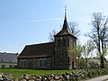
Brunow village church

Klüß village church

Cattle on a pasture in Klüß


literature
- Friedrich Schlie : The art and history monuments of the Grand Duchy of Mecklenburg-Schwerin . The district court districts of Hagenow, Wittenburg, Boizenburg, Lübenheen, Dömitz, Grabow, Ludwigslust, Neustadt, Crivitz, Brüel, Warin, Neubukow, Kröpelin and Doberan. III. Tape. Schwerin 1899, p. 215 ff . ( Digitized in the Internet Archive [accessed on August 19, 2015]).
Web links
Individual evidence
- ↑ Statistisches Amt MV - population status of the districts, offices and municipalities 2019 (XLS file) (official population figures in the update of the 2011 census) ( help ).
- ^ § 2 of the main statute (PDF; 199 kB) of the municipality
- ↑ Main statutes, § 3, paragraph 2

Alt Krenzlin | Old Zachun | Balow | Bandenitz | Banzkow | Barkhagen | Barnin | Belsch | Bengerstorf | Possession | Blankenberg | Blievenstorf | Bobzin | Boizenburg / Elbe | Borkow | Brahlstorf | Brenz | Bresegard at Eldena | Bresegard near Picher | Bruel | Brunow | Bülow | Cambs | Crivitz | Dabel | Dambeck | Demes | Dersenow | Dobbertin | Dobin at the lake | Dömitz | Domsühl | Dumber | Eldena | Friedrichsruhe | Gallin | Gallin Cupcentess | Gammelin | Ganzlin | Gehlsbach | Gneven | Göhlen | Goldberg | Gorlose | Grabow | Granzin | Grebs-Niendorf | Greetings | Greven | Great Godems | Big stuff | Groß Laasch | Hagenow | Hohen Pritz | Holthusen | Hoort | Hülseburg | Parental leave | Karrenzin | Karstädt | Church of Jesar | Klein Rogahn | Tempzin Monastery | Kobrow | Kogel | Circling | Kremmin | Kritzow | Kuhlen-Wendorf | Cow peat | Langen Brütz | Leezen | Lewitzrand | Luebesse | Lueblow | Lübheen | Luebz | Ludwigslust | Lüttow-Valluhn | Malk Göhren | Malliss | Mestlin | Milow | Möllenbeck | Moraas | Muchow | Mustin | New Gülze | New Kaliss | New Poserin | Neustadt-Glewe | Nostorf | Upper Warnow | Pampow | Parchim | Passow | Pätow-Steegen | Picher | Pinnow | Plate | Plau am See | Prislich | Pritzier | Raben Steinfeld | Rastow | Redefin | Rome | Ruhner Mountains | Lap in | Schwanheide | Siggelkow | Spornitz | Sternberg | Stumble | Stralendorf | Straw churches | Sukow | Sülstorf | Techentin | Teldau | Ticino | Toddin | Tramm | Uelitz | Vellahn | Vielank | Warlitz | Warlow | Warsow | Weitendorf | Werder | Wittenburg | Wittendbod | Wittenförden | Witch | Wöbbelin | Zapel | Zarrentin am Schaalsee | Ziegendorf | Zierzow | Zölkow | Zulow