
Parchim district
| Basic data | |
|---|---|
| District : | Schwerin |
| Administrative headquarters : | Parchim |
| Area : | 677 km² |
| Residents: | 39,500 (Dec. 31, 1985) |
| Population density: | 58 inhabitants per km² |
| License plate : | B (1953-1990) PCH (1991-1994) |
| Circle structure: | 24 municipalities |
| Location of the district in the GDR | |
  |
|


The Parchim district was a district of the Schwerin district in the GDR . From May 17, 1990, it continued as Parchim district . Today his area belongs to the Ludwigslust-Parchim district in Mecklenburg-Western Pomerania . The seat of the district administration was in Parchim .
geography
location
The district area was characterized in the northwest by the Lewitz , a depression washed out by meltwater after the Ice Age with wide meadows and arable land, and in the south by a terminal moraine , the Ruhner Mountains . At 177 meters above sea level, the Ruhner Berg was the highest mountain in the Schwerin district. Other elevations are the Lange Berg (125 m) near the Parchimer district of Kiekindemark and the Tempelberg (83 m) near Frauenmark . The deepest layers were within the Lewitz on the banks of the Elde (approx. 40 m above sea level).
The North Sea-Baltic Sea watershed runs through the demarcation of the former district . While the Müritz-Elde waterway , this is the canalised course of the Elde, whose original river bed has been preserved in parts in the form of side arms, and the Löcknitz , which rises near Ziegendorf, drain over the Elbe into the North Sea, the Warnow , whose source is at Grebbin is located in the Baltic Sea.
In the area with few lakes, the Treptowsee near Redlin and the Wockersee in Parchim are noteworthy. There are larger forest areas south of Parchim.
Area and population
The area of the district was 677 km². That corresponded to 7.8% of the area of the Schwerin district.
The population was around 39,500 in 1985. That was 6.6% of the district's population. The population density was 58 inhabitants per km².
Neighboring areas
The circle Parchim bordered to the north by the county Sternberg , on the east by the county Lübz , on the south by the county Perleberg , in the southwest of the county Ludwigslust , in the northwest on the district Schwerin-country and on the southeast by the the district of Potsdam belonging county Pritzwalk .
history
The Mecklenburg district of Parchim was created on July 25, 1952 from the old district of Parchim , ceding the eastern half, which formed the new district of Lübz , and belonged to the newly formed district of Schwerin. On May 17, 1990 the district became Parchim. He came to the newly founded state of Mecklenburg-Western Pomerania on October 3, 1990, within the accession area to the Federal Republic of Germany . On June 12, 1994 the district was dissolved and together with the district of Lübz and parts of the districts of Sternberg and Schwerin it became the new district of Parchim .
Economy and Infrastructure
Large parts of the soil were used for agriculture, especially for growing rye, barley and potatoes. In addition to the hydraulic works, the poultry farm and the canning factory, companies for the production of upholstery fabrics and aerated concrete were represented in Parchim.
The 191 trunk road ran through the Parchim district from Ludwigslust to Lübz . The F 321 connected the district with Schwerin and Pritzwalk . Since 1982, a section of the Hamburg – Berlin transit motorway ran through the district with the Parchim and Suckow junctions . A motorway service station already existed in the GDR era at Stolpe . After the withdrawal of the Russian armed forces, Schwerin-Parchim Airport was used privately and has since been expanded for civil aviation.
photos

Round wood near Frauenmark
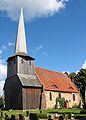
Village church in Suckow
Weather station in Marnitz

Imperial Post Office in Parchim


cities and communes
The place Ruhn near Marnitz fell in 1982 and was demolished. On July 18, 1992, the districts of Pampin and Platschow of the Brandenburg municipality of Berge moved to the municipality of Ziegendorf .
On October 3, 1990, the Parchim district had 24 parishes, one of which was a town:
License Plate
Motor vehicles (with the exception of motorcycles) and trailers were assigned three-letter distinctive signs starting with the letter pairs BK and BL from around 1974 to the end of 1990 . The last number plate series used for motorcycles was BT 00–01 to BT 10–40 .
At the beginning of 1991 the district received the distinctive sign PCH .
Individual evidence
- ↑ a b Federal Statistical Office (ed.): Municipalities 1994 and their changes since 01.01.1948 in the new federal states . Metzler-Poeschel, Stuttgart 1995, ISBN 3-8246-0321-7 .
- ↑ Law on the self-administration of municipalities and districts in the GDR (municipal constitution) of May 17, 1990
- ↑ Andreas Herzfeld: The history of the German license plate . 4th edition. German Flag Society V., Berlin 2010, ISBN 978-3-935131-11-7 , pp. 301 .
- ↑ Andreas Herzfeld: The history of the German license plate . 4th edition. German Flag Society V., Berlin 2010, ISBN 978-3-935131-11-7 , pp. 551 .