
Schwerin-Land district


The Schwerin-Land district was a district in the Schwerin district in the GDR . From May 17, 1990 it continued as the district of Schwerin . Today his area belongs to the districts of Ludwigslust-Parchim and Northwest Mecklenburg in Mecklenburg-Western Pomerania . The seat of the district administration was in the city of Schwerin , which itself did not belong to the district.
geography
location
The district comprised almost the entire northern part of the Schweriner See ( outer lake without Lieps island ), the hilly areas to the west, east and south-east of the lake as well as flat and wooded areas in the south to the lowland area of the Lewitz . The North Sea-Baltic Sea watershed ran through the district in a north-south direction. While the Schweriner See with the sturgeon drains over the Elde to the North Sea, the Warnow flows in the east of the district to the Baltic Sea. The larger lakes in the Schwerin-Land district included the Cambser See , the Pinnower See and the Barniner See . The highest point was the Homberg near Cambs- Kleefeld at 98 m above sea level. NN .
Area and population
The area of the district was 857 km². That corresponded to 9.9% of the area of the Schwerin district.
The population was about 34,200 in 1985. That was 5.8% of the district's residents. The population density was 40 inhabitants per km².
Neighboring areas
The Schwerin-Land district completely enclosed the Schwerin district and bordered the Grevesmühlen district in the north- west, the Gadebusch district in the west, the Hagenow district in the south-west, the Ludwigslust district in the south, the Parchim district in the south-east , and the north-east the district of Sternberg and in the north to the district of Wismar .
history
The former Mecklenburg district of Schwerin , which emerged from the office of Schwerin , was divided when the federal states were dissolved on July 25, 1952. The new district of Gadebusch emerged from the north-western part of the area , the larger remainder belonged to the newly formed district of Schwerin as the Schwerin-Land district. The district came to the newly founded state of Mecklenburg-Western Pomerania on October 3, 1990 within the accession area to the Federal Republic of Germany . On June 12, 1994, the district (since May 17, 1990 referred to as the Schwerin district ) was dissolved and divided into three parts: the north-west fell to the newly founded north-west Mecklenburg district , the south-east and east became part of the Parchim district , and the south-west - and the southern part were incorporated into the Ludwigslust district.
coat of arms
The coat of arms was approved by the Ministry of the Interior on October 16, 1992 and registered under number 37 in the coat of arms of Mecklenburg-Western Pomerania.
Blazon : "In blue a left flank divided by red and gold, accompanied by a silver horse's head."
According to the design principle of the pars pro toto, the horse's head and the colors of the flank are intended to commemorate the County of Schwerin, which was formed in 1167 and to which most of the district area belonged until the end of 1358. The horse's head is also intended to establish a connection to the state capital Schwerin, the district seat, and to symbolize the district as an area traditionally characterized by agriculture and the rural way of life.
The coat of arms was designed by the Wismar heraldist Roland Bornschein .
Economy and Infrastructure
Agriculture and forestry played the main role in the Schwerin-Land district, the most sparsely populated district in the Schwerin district. The largest forest nursery in the GDR was located in the Gädebehn forest near Crivitz .
The main traffic axes in the circle ran radially towards Schwerin . The Schwerin-Berlin motorway ran through the area of the district as did the F 104 , F 106 and F 321 . This also applied to the railway lines (routes Schwerin-Berlin, Schwerin-Wismar / Rostock ). The railway lines from Schwerin to Gadebusch , to Hagenow and to Parchim were of secondary importance.
photos
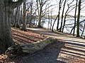
Landscape park on Lake Schwerin in Raben Steinfeld

Church in Pampow

Village church in Sülstorf


cities and communes
On October 3, 1990, the district of Schwerin had 47 communities, one of which was a city:
License Plate
Motor vehicles (with the exception of motorcycles) and trailers were assigned three-letter distinctive signs beginning with the letter pairs BP , BR , BS and BT from around 1974 to the end of 1990 . The last number plate series used for motorcycles was BY 00-01 to BY 25-00 .
At the beginning of 1991, the district and the city of Schwerin were given the distinguishing mark SN . It was issued in the county until June 11, 1994.
Individual evidence
- ↑ a b Federal Statistical Office (ed.): Municipalities 1994 and their changes since 01.01.1948 in the new federal states . Metzler-Poeschel, Stuttgart 1995, ISBN 3-8246-0321-7 .
- ↑ Law on the self-administration of municipalities and districts in the GDR (municipal constitution) of May 17, 1990
- ↑ Andreas Herzfeld: The history of the German license plate . 4th edition. German Flag Society V., Berlin 2010, ISBN 978-3-935131-11-7 , pp. 301 .
- ↑ Andreas Herzfeld: The history of the German license plate . 4th edition. German Flag Society V., Berlin 2010, ISBN 978-3-935131-11-7 , pp. 551 .