Godern
|
Godern
community Pinnow
|
||
|---|---|---|
| Coordinates: 53 ° 37 ′ 8 ″ N , 11 ° 32 ′ 35 ″ E | ||
| Height : | 40 m | |
| Area : | 4.59 km² | |
| Residents : | 328 (Dec. 31, 2010) | |
| Population density : | 71 inhabitants / km² | |
| Incorporation : | January 1, 2012 | |
| Postal code : | 19065 | |
| Area code : | 03860 | |
|
Location of Godern in Mecklenburg-Western Pomerania |
||
|
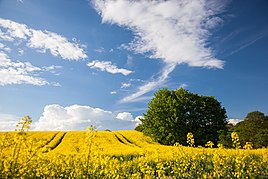
Rape field west of Godern
|
||
Godern is a part of the municipality of Pinnow . Until the end of 2011 Godern was an independent municipality with the districts of Godern and Neu Godern.
Geography and traffic
The village of Godern is located between the Pinnower See in the southwest, the smaller Mühlensee in the east and the Hohes Holz forest in the north. In the latter are with over 75 m above sea level. NHN also has the highest elevations in the local area. Almost a third of the local area is covered with forest.
South of Godern there is a connection to the B 321 and A 14 , further north to the B 104 . Nearby cities are Schwerin and Crivitz .
history
Godern was first mentioned in 1376 under the Slavic name "Gudeware". The area was inhabited earlier. There is an old, disused water mill at the Mühlbach. Like the entire surrounding area, Godern was affected by the Thirty Years War . In 1646 the place is said to have been almost destroyed by a fire. The area belonged to the Grand Duchy of Mecklenburg-Schwerin until 1918 , then to the state of Mecklenburg , which was replaced by the Schwerin district in 1952 . From 1952 to 1994 the community was part of the Schwerin-Land district , Godern has been part of the Parchim district since 1994, and the Ludwigslust-Parchim district from 2011. After 1990, the number of inhabitants rose sharply due to the newly developed residential areas. There is a swimming area on the shores of the Pinnower See. On January 1, 2012 Godern was incorporated into Pinnow.
politics
coat of arms
|
Blazon : "In gold over a red shield base, inside an eight-spoke, eight-bladed golden mill wheel, a torn green chestnut, on both sides accompanied by a red horseshoe with six nail holes."
The coat of arms was designed by Roland Bornschein from Wismar . It was approved on September 5, 1997 by the Ministry of the Interior and registered under the number 138 of the coat of arms of the state of Mecklenburg-Western Pomerania. |
|
| Explanation of the coat of arms: In the coat of arms, the figures refer in particular to trades that were important in the past of the place: for example, the mill wheel to the undershot water mill, which can be proven as early as 1474, and the horseshoes to the blacksmiths and carts forge in Godern, mentioned in 1823 and still functioning today. In addition, the number of horseshoes symbolize the two districts. The chestnut stands for the chestnut avenue leading to Godern. In terms of tinging, the color red and the metal gold are reminiscent of Godern's affiliation to the medieval county of Schwerin. When it was incorporated into the community of Pinnow on January 1, 2012, the community coat of arms lost its status as a national emblem. However, it can still be used by the residents as an identification symbol and as a sign of solidarity with their place. |
flag
The former municipality did not have an officially approved flag .
Attractions
- Winter linden tree near Goderner Mühle (trunk circumference 5.80 meters)
- Pinnower See
Personalities
- Günter Millahn (* 1930 near Schwerin ; † 2018), forester, educator, hunter and author; lives in Godern
Web links
- www.godern-online.de
- www.amt-ostufer-schweriner-see.de/ ( Memento from April 14, 2014 in the Internet Archive )
Individual evidence
- ↑ Changes in the municipalities of Germany, see 2012 StBA
- ↑ a b Hans-Heinz Schütt: On shield and flag - the coats of arms and flags of the state of Mecklenburg-Western Pomerania and its municipalities . Ed .: production office TINUS; Schwerin. 2011, ISBN 978-3-9814380-0-0 , pp. 196 .


