
District of Hagenow

The Hagenow district was a district in the west of the Schwerin district in the GDR . From May 17, 1990 he continued as the district of Hagenow . Today his area belongs mainly to the Ludwigslust-Parchim district in Mecklenburg-Western Pomerania . The seat of the district administration was in Hagenow .
geography

location
The southeastern part of the former district area is characterized by the Griese area , a landscape with little lakes and sandy soils. Parts of the Hagenower Land were used as a military training area. In the north of the district the agricultural use of the land predominated, while in the south the grassland and forest share was higher.
The rivers Schaale , Schilde , Motel , Sude , Boize and Krainke , which drain into the Elbe, run within the district area . The river formed the inner-German border here . Because the border also ran through the Schaalsee lake in the north of the district with the Kampenwerder island in it , the lake was inaccessible from the east and largely untouched by human interference for decades.
Elevations form, for example, the Granziner Heidberge, with up to 103 meters south of Granzin , the Mecklenburg mountains with 83 meters directly south of it, the Stichsockenberg east of the Schaalsee with 73 meters and the Lange Berg with 65 m above sea level. NN north of Vellahn . The Elbe valley floodplain, on the other hand, is only about 10 meters above sea level.
Area and population
The area of the district was 1550 km². this corresponded to 17.9% of the area of the Schwerin district.
The population of the district was around 73,000 in 1985. That was 12.3% of the district's population. The population density was 47 inhabitants per km².
Neighboring areas
The Gadebusch district, the largest in terms of area, bordered the Gadebusch district in the north, the Schwerin-Land district in the northeast, the Ludwigslust district in the southeast, and the German districts of Lüchow-Dannenberg in the south, Lüneburg in the west and the Duchy of Lauenburg in the northwest. The district of Hagenow had by far the longest border of all border districts on the inner-German border.
history
The Mecklenburg district of Hagenow was created when the federal states were dissolved on July 25, 1952 from the district of Hagenow , which had existed since 1933 and which had been enlarged in 1945 to include the Neuhaus district , which was changed from the British to the Soviet occupation zone . He belonged to the newly formed Schwerin district in 1952. On May 17, 1990 the district became the district of Hagenow. He came to the newly founded state of Mecklenburg-Western Pomerania on October 3, 1990, within the accession area to the Federal Republic of Germany . On June 30, 1993, eight communities and some parcels of land moved to the Lower Saxony district of Lüneburg . On June 12, 1994, the district was dissolved and merged with the Ludwigslust district and the southwest and southern parts of the Schwerin district to form the new Ludwigslust district.
Economy and Infrastructure
The district was more agricultural, although only soils with a low land value number were found. Mainly rye and potatoes were grown. There are extensive orchards around Dodow and Schwechow, the harvest of which is still processed into juices and baby food. The Redefin State Stud was of supraregional importance for horse breeding and later also for tourism. The largest tile factory in the GDR was located in Boizenburg, and passenger ships were also manufactured in the Elbe shipyard . In Hagenow, the potato processing plant was already producing in GDR times and there was a production facility for processed cheese. Wittenburg was the milk processing location, truck bodies and containers were manufactured in Lübheen. By 1989, the exploration of the lignite deposits around Lübenheen was well advanced.
The 195 trunk road runs parallel to the Elbe from Zarrentin to Dömitz . There was no bridge connection over the Elbe along the south-western border of the district. The F 5 from Boizenburg in the direction of Ludwigslust was a transit route until the Hamburg – Berlin autobahn was completed in 1982. The Berlin – Hamburg railway also ran through the district.
photos

Town hall in Boizenburg
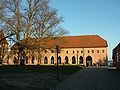
Enclosed building of the Cistercian convent Zarrentin


cities and communes
In the course of the turnaround, the community of Groß Krams was able to establish independence on May 1, 1990 by hiving off the community of Redefin . The municipalities of Dellin , Haar , Kaarßen , Neuhaus / Elbe , Stapel , Sückau, Sumte and Tripkau as well as the districts of Neu Bleckede, Neu Wendischthun and Stiepelse of the municipality of Teldau and a parcel of the municipality of Garlitz switched to a new state treaty between Mecklenburg-Western Pomerania and Lower Saxony . June 1993 to the Lower Saxony district of Lüneburg, to which they had already belonged before the beginning of the Second World War. There they mostly belong to the unified community of Amt Neuhaus , which was founded on October 1, 1993 .
On October 3, 1990, the district of Hagenow had the highest number of municipalities in the GDR with 73 municipalities, including five cities:
1 ) The Parum parish was divided years after the Hagenow district was dissolved. The place Parum moved in 1999 to the municipality Dümmer in the district of Northwest Mecklenburg, the district Pogreß went to the newly founded municipality Wittendbod.
License Plate
Motor vehicles (with the exception of motorcycles) and trailers were assigned three-letter distinctive signs starting with the letter pairs BE and BF from around 1974 to the end of 1990 . The last number plate series used for motorcycles was BS 23–96 to BS 51–65 .
At the beginning of 1991 the district received the distinguishing mark HGN . It was issued until June 11, 1994. It has been available in the Ludwigslust-Parchim district since August 1, 2013 .
Individual evidence
- ↑ a b Federal Statistical Office (ed.): Municipalities 1994 and their changes since 01.01.1948 in the new federal states . Metzler-Poeschel, Stuttgart 1995, ISBN 3-8246-0321-7 .
- ↑ Law on the self-administration of municipalities and districts in the GDR (municipal constitution) of May 17, 1990
- ↑ Andreas Herzfeld: The history of the German license plate . 4th edition. German Flag Society V., Berlin 2010, ISBN 978-3-935131-11-7 , pp. 301 .
- ↑ Andreas Herzfeld: The history of the German license plate . 4th edition. German Flag Society V., Berlin 2010, ISBN 978-3-935131-11-7 , pp. 550 .
Coordinates: 53 ° 26 ' N , 11 ° 11' E