
Dümmer (municipality)
| coat of arms | Germany map | |
|---|---|---|

|
Coordinates: 53 ° 35 ' N , 11 ° 12' E |
|
| Basic data | ||
| State : | Mecklenburg-Western Pomerania | |
| County : | Ludwigslust-Parchim | |
| Office : | Stralendorf | |
| Height : | 51 m above sea level NHN | |
| Area : | 31.36 km 2 | |
| Residents: | 1506 (Dec. 31, 2019) | |
| Population density : | 48 inhabitants per km 2 | |
| Postal code : | 19073 | |
| Area code : | 03869 | |
| License plate : | LUP, HGN, LBZ, LWL, PCH, STB | |
| Community key : | 13 0 76 036 | |
| Community structure: | 3 districts | |
| Office administration address: | Dorfstrasse 30 19073 Stralendorf |
|
| Website : | ||
| Mayoress : | Anke Gräber | |
| Location of the municipality of Dümmer in the Ludwigslust-Parchim district | ||
 _in_LUP.svg) |
||

Dümmer is a municipality in the Ludwigslust-Parchim district in Mecklenburg-Western Pomerania, Germany. It is administered by the Stralendorf Office , based in the Stralendorf municipality.
geography
Dümmer is about 14 kilometers southwest of Schwerin and 16 kilometers north of Hagenow on the Dümmersee , through which the Sude flows.
Dümmer is surrounded by the neighboring communities Gottesgabe in the north, Grambow and Zülow in the northeast, Stralendorf in the east, Warsow and Schossin in the southeast, Hülseburg in the south, Wittendbod in the west and Perlin in the northwest.
The districts of the municipality are:
- Dümmer (with Dümmerhütte, Dümmerstück, Dümmerstück Hof, Kowahl)
- Parum (incorporated on June 13, 1999)
- Walsmühlen (incorporated on January 15, 1973)

Entrance to Dümmer from the east

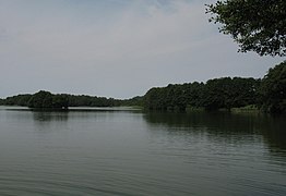
Dümmersee
Dümmersee with castle island


history
Barrows and urn fields testify that people lived again and again near the Dümmer See in the millennia after the Ice Age. B. Slavic settlers, the Obotrites . The place name also comes from the West Slavic language Polabisch , in which the word “düm” stands for family and house.
Dümmer was first mentioned in the Ratzeburg tithe register in 1230. In the case of Walsmühlen, it is assumed that a mill built on the Sude gave its name. The name of the Dümmerhütte settlement is explained by the glassworks that have been located in Dümmer since 1645 . Parum was first mentioned in 1194. The first school in Dümmer was opened in 1710. On March 6, 1719, a battle between Mecklenburg and Hanoverian troops took place in the district during the Great Northern War , with the Mecklenburg troops being led by the later Prussian General Field Marshal Kurt Christoph von Schwerin .
On July 1, 1950, the previously independent communities Dümmerhütte and Dümmerstück Hof were incorporated.
In 1968 a local recreation area was created on the Dümmersee.
politics
The municipal council elected in 2019 is composed as follows:
- “Citizens for our community”: 6 seats
- CDU : 1 seat
- Individual applicant Herrmann
- Single applicant Rolof
- Single applicant Schmidt
Coat of arms, flag, official seal
The municipality has no officially approved national emblem, neither a coat of arms nor a flag. The official seal is the small state seal with the coat of arms of the state of Mecklenburg. It shows a looking bull's head with a torn neck fur and crown and the inscription "GEMEINDE DÜMMER • LANDKREIS LUDWIGSLUST-PARCHIM".

Dorfstrasse 35

Dorfstrasse 39b

Stücker Str. 10

Forsthof (from the west)

Forsthof (from the southeast)


Attractions

- The Parum village church is a Gothic brick church with a fieldstone base, the nave of which was built around 1450. The building in the Parum district was expanded around 1770 with the wooden tower and around 1870 with a new choir and the transept in the neo-Gothic style . The interior is also neo-Gothic.
- The Schlossberg in Schleusenholz, east of Dümmer, is a medieval castle . According to tradition from the 14th century, it was built by vassals of the Ratzeburg monastery . Because of its proximity to the county of Schwerin , it was of particular importance. The mountain, which is overgrown by a forest today, and the ditch surrounding it is designated as a ground monument , recognizable by a sign.
Transport links
The next connection to the federal motorway 24 is in Wittenburg , 13 kilometers away.
Web links
Individual evidence
- ↑ Statistisches Amt MV - population status of the districts, offices and municipalities 2019 (XLS file) (official population figures in the update of the 2011 census) ( help ).
- ↑ Reading version - main statute of the municipality of Dümmer. (PDF; 22 kB) Dümmer community, December 12, 2011, accessed on February 4, 2016 .
- ↑ StBA: Changes in the municipalities in Germany, see 1999
- ↑ Municipalities 1994 and their changes since January 1, 1948 in the new federal states , Metzler-Poeschel publishing house, Stuttgart, 1995, ISBN 3-8246-0321-7 , publisher: Federal Statistical Office
- ↑ Final results of the 2019 local elections. Accessed July 9, 2019 .
- ↑ Main Statute, Section 2, Paragraph 1
- ↑ Zerniner Employment Initiative (ZEBI) e. V. and START e. V. (Ed.): Village and town churches in the Parchim parish . Edition Temmen, Bremen / Rostock 2001, ISBN 3-86108-795-2 , p. 130

Alt Krenzlin | Old Zachun | Balow | Bandenitz | Banzkow | Barkhagen | Barnin | Belsch | Bengerstorf | Possession | Blankenberg | Blievenstorf | Bobzin | Boizenburg / Elbe | Borkow | Brahlstorf | Brenz | Bresegard at Eldena | Bresegard near Picher | Bruel | Brunow | Bülow | Cambs | Crivitz | Dabel | Dambeck | Demes | Dersenow | Dobbertin | Dobin at the lake | Dömitz | Domsühl | Dumber | Eldena | Friedrichsruhe | Gallin | Gallin Cupcentess | Gammelin | Ganzlin | Gehlsbach | Gneven | Göhlen | Goldberg | Gorlose | Grabow | Granzin | Grebs-Niendorf | Greetings | Greven | Great Godems | Big stuff | Groß Laasch | Hagenow | Hohen Pritz | Holthusen | Hoort | Hülseburg | Parental leave | Karrenzin | Karstädt | Church of Jesar | Klein Rogahn | Tempzin Monastery | Kobrow | Kogel | Circling | Kremmin | Kritzow | Kuhlen-Wendorf | Cow peat | Langen Brütz | Leezen | Lewitzrand | Luebesse | Lueblow | Lübheen | Luebz | Ludwigslust | Lüttow-Valluhn | Malk Göhren | Malliss | Mestlin | Milow | Möllenbeck | Moraas | Muchow | Mustin | New Gülze | New Kaliss | New Poserin | Neustadt-Glewe | Nostorf | Upper Warnow | Pampow | Parchim | Passow | Pätow-Steegen | Picher | Pinnow | Plate | Plau am See | Prislich | Pritzier | Raben Steinfeld | Rastow | Redefin | Rome | Ruhner Mountains | Lap in | Schwanheide | Siggelkow | Spornitz | Sternberg | Stumble | Stralendorf | Straw churches | Sukow | Sülstorf | Techentin | Teldau | Ticino | Toddin | Tramm | Uelitz | Vellahn | Vielank | Warlitz | Warlow | Warsow | Weitendorf | Werder | Wittenburg | Wittendbod | Wittenförden | Witch | Wöbbelin | Zapel | Zarrentin am Schaalsee | Ziegendorf | Zierzow | Zölkow | Zulow