
Holthusen
| coat of arms | Germany map | |
|---|---|---|

|
Coordinates: 53 ° 33 ' N , 11 ° 21' E |
|
| Basic data | ||
| State : | Mecklenburg-Western Pomerania | |
| County : | Ludwigslust-Parchim | |
| Office : | Stralendorf | |
| Height : | 48 m above sea level NHN | |
| Area : | 20.57 km 2 | |
| Residents: | 926 (Dec. 31, 2019) | |
| Population density : | 45 inhabitants per km 2 | |
| Postal code : | 19075 | |
| Area code : | 03865 | |
| License plate : | LUP, HGN, LBZ, LWL, PCH, STB | |
| Community key : | 13 0 76 063 | |
| Community structure: | 4 districts | |
| Office administration address: | Dorfstrasse 30 19073 Stralendorf |
|
| Website : | ||
| Mayoress : | Marianne Facklam | |
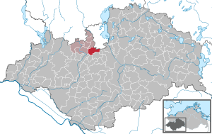
| Location of the municipality of Holthusen in the Ludwigslust-Parchim district | ||
  |
||

Holthusen is a municipality in the Ludwigslust-Parchim district in Mecklenburg-Western Pomerania, Germany. It is administered by the Stralendorf Office , based in the Stralendorf municipality.
geography
Holthusen is located about seven kilometers south of the state capital Schwerin.
The districts of Holthusen, Lehmkuhlen, Holthusen station and Buchholz belong to the community .
history
The first written mention of Holthusen goes back to 1248. The place south of Schwerin is recorded on a map of the county of Schwerin around 1250. In the Thirty Years' War , the village was largely destroyed. In 1868 the towns of Buchholz and Holthusen merged into one community. Throughout history, the four districts were mainly characterized by agriculture.
On January 1, 1951, the previously independent municipality of Lehmkuhlen was incorporated.
After 1990, it was mainly the city-exodus from Schwerin into the surrounding area that led to an increase in the number of residents. The place became known nationwide in the 1990s, when the (now discontinued) plans for the Transrapid connection Hamburg-Berlin in Holthusen provided for the only stopover for Schwerin.
The name of the district Lehmkuhlen goes back to the clay deposits and their mining, remnants of the clay hollows can still be seen today.
politics
Community representation
The municipal council elected in 2019 is composed as follows:
- CDU : 4 seats
- The left : 1 seat
- Alliance farmers and rural areas: 1 seat
- Brasch single applicant
- Individual applicant Groth
coat of arms
|
|
Blazon : “Split; in front a red abbess's staff in gold; in the back three golden linden leaves with fruits in stalks in blue. "
The coat of arms and the flag were designed by Horst Schmedemann from Warsow . It was approved together with the flag on April 29, 2005 by the Ministry of the Interior and registered under No. 297 of the coat of arms of the state of Mecklenburg-Western Pomerania. |
| Justification of the coat of arms: In the coat of arms, the abbess's staff is used to refer to the first mention of the village of Holthusen in connection with the furnishing of a newly founded nunnery that was located near Zarrentin in 1251. At the same time, the staff will commemorate the three hundred years that parts of the village have belonged to the monastery. On the one hand, the linden leaves stand for the tree species that characterizes the community, and on the other, they are meant to symbolize the growing together of the three districts. While the golden and red tinging of the front field is intended to remind of the affiliation of Holthusen, Lehmkuhlen and the Buchholz forest to the former County of Schwerin, the tinging of the coat of arms in blue, gold and red refers to the affiliation of the municipality to the Mecklenburg region. |
flag

The flag has yellow and blue stripes evenly across the longitudinal axis of the flag cloth. Each stripe is covered in the middle with a figure of the municipal coat of arms: the yellow stripe with a red abbess's staff, the blue stripe with three yellow linden leaves and fruits. Each figure is seven eighths the height of the flagcloth. The height of the flag is related to the length like 2: 3.
Official seal
The official seal shows the municipal coat of arms with the inscription "GEMEINDE HOLTHUSEN".
Economy and Infrastructure
In the 1990s, two industrial parks were created, each with an area of around six hectares. Planning for a third industrial park has been completed. A total of over 50 companies from the trade, transport and disposal sectors as well as from the manufacturing industry have settled here.
Transport links
The federal highway 321 leads two kilometers west of Holthusen, the federal highway 24 can be reached in nine kilometers via the connection Hagenow .
The Hagenow Land – Schwerin railway runs through the built-up center , while the Ludwigslust – Schwerin railway runs past to the east. Both routes unite north of the town of Holthusen. Here, in the district of Holthusen Bahnhof, is the train station. It was here that the Holthusen railway accident occurred on December 31, 1992 .
Attractions
The architectural monuments of the community are listed in the list of architectural monuments in Holthusen .

Chapel in Holthusen

War memorial in Holthusen

former reception building of the Holthusen train station


Web links
Individual evidence
- ↑ Statistisches Amt MV - population status of the districts, offices and municipalities 2019 (XLS file) (official population figures in the update of the 2011 census) ( help ).
- ↑ § 1 of the main statute (PDF; 22 kB) of the municipality
- ↑ Final results of the 2019 local elections. Accessed July 9, 2019 .
- ↑ Hans-Heinz Schütt: On shield and flag - the coats of arms and flags of the state of Mecklenburg-Western Pomerania and its municipalities . Ed .: production office TINUS; Schwerin. 2011, ISBN 978-3-9814380-0-0 , pp. 126/127 .
- ↑ a b main statute § 2 (PDF).

Alt Krenzlin | Old Zachun | Balow | Bandenitz | Banzkow | Barkhagen | Barnin | Belsch | Bengerstorf | Possession | Blankenberg | Blievenstorf | Bobzin | Boizenburg / Elbe | Borkow | Brahlstorf | Brenz | Bresegard at Eldena | Bresegard near Picher | Bruel | Brunow | Bülow | Cambs | Crivitz | Dabel | Dambeck | Demes | Dersenow | Dobbertin | Dobin at the lake | Dömitz | Domsühl | Dumber | Eldena | Friedrichsruhe | Gallin | Gallin Cupcentess | Gammelin | Ganzlin | Gehlsbach | Gneven | Göhlen | Goldberg | Gorlose | Grabow | Granzin | Grebs-Niendorf | Greetings | Greven | Great Godems | Big stuff | Groß Laasch | Hagenow | Hohen Pritz | Holthusen | Hoort | Hülseburg | Parental leave | Karrenzin | Karstädt | Church of Jesar | Klein Rogahn | Tempzin Monastery | Kobrow | Kogel | Circling | Kremmin | Kritzow | Kuhlen-Wendorf | Cow peat | Langen Brütz | Leezen | Lewitzrand | Luebesse | Lueblow | Lübheen | Luebz | Ludwigslust | Lüttow-Valluhn | Malk Göhren | Malliss | Mestlin | Milow | Möllenbeck | Moraas | Muchow | Mustin | New Gülze | New Kaliss | New Poserin | Neustadt-Glewe | Nostorf | Upper Warnow | Pampow | Parchim | Passow | Pätow-Steegen | Picher | Pinnow | Plate | Plau am See | Prislich | Pritzier | Raben Steinfeld | Rastow | Redefin | Rome | Ruhner Mountains | Lap in | Schwanheide | Siggelkow | Spornitz | Sternberg | Stumble | Stralendorf | Straw churches | Sukow | Sülstorf | Techentin | Teldau | Ticino | Toddin | Tramm | Uelitz | Vellahn | Vielank | Warlitz | Warlow | Warsow | Weitendorf | Werder | Wittenburg | Wittendbod | Wittenförden | Witch | Wöbbelin | Zapel | Zarrentin am Schaalsee | Ziegendorf | Zierzow | Zölkow | Zulow