
Kobrow
| coat of arms | Germany map | |
|---|---|---|

|
Coordinates: 53 ° 41 ′ N , 11 ° 49 ′ E |
|
| Basic data | ||
| State : | Mecklenburg-Western Pomerania | |
| County : | Ludwigslust-Parchim | |
| Office : | Sternberg lake landscape | |
| Height : | 35 m above sea level NHN | |
| Area : | 37.48 km 2 | |
| Residents: | 402 (Dec. 31, 2019) | |
| Population density : | 11 inhabitants per km 2 | |
| Postal code : | 19406 | |
| Area code : | 03847 | |
| License plate : | LUP, HGN, LBZ, LWL, PCH, STB | |
| Community key : | 13 0 76 072 | |
| Community structure: | 5 districts | |
| Office administration address: | Am Markt 1 19406 Sternberg |
|
| Website : | ||
| Mayor : | Olaf Schröder | |
| Location of the municipality of Kobrow in the Ludwigslust-Parchim district | ||
  |
||

Kobrow is a municipality in the Ludwigslust-Parchim district in Mecklenburg-Western Pomerania . It is administered by the Sternberger Seenlandschaft office based in the town of Sternberg .
Geography and traffic
Kobrow is located two kilometers south of Sternberg in the Sternberg Lake District . The community is surrounded by a wooded lake landscape. There are three larger lakes in the municipality: Schönfelder See , Dannhuser See and Hofsee . Kobrow itself is located on the Hofsee. The community borders the B 192 in the north . The heights in the municipality are just under 60 m above sea level. NHN .
The districts of the municipality are Wamckow, Kobrow I, Dessin, Kobrow II and Stieten.
history
Kobrow
Kobrow was first mentioned in a document on May 5, 1307, when Prince Heinrich von Mecklenburg sold his share in the village of Kobrow to Heinrich Trendekopp, a citizen of Sternberg. In 1325 Heinrich von Mecklenburg founds a vicarie in the Sternberg church and gift II houen in dorp Kobrow. On April 7, 1333, Prince Albrecht of Mecklenburg pledged the Doberan Monastery, in addition to the Bede already pledged by King Erich of Denmark , the justice in the villages of Parkentin and Bartenshagen. Arnoldus de Gotland, Thidiricus Horn as Consul in Rostock and Johannes Roekogele as Magister in Wismar were also present as witnesses . This important legal act in the presence of numerous political dignitaries took place in the Kobrow cemetery.
The origin of the name Kobrow is interpreted differently. On the one hand, it could be derived from the Old Slavic kovru and Polish kobierzec , which would mean carpet. Others see a derivation from the word Koberov , which could be a field or water name, which in turn could have its origin in the Polabian word kobère , which stands for burdock. It is also possible to derive from the Old Slavic word kob for prophecy, kobyla for mare or from Wendish kobrow for dill farm, i.e. farm on which dill is grown.
The place was originally a noble estate. From 1848 Kobrow is mentioned at the Dominal Office. In 1908 a farming village with eight leaseholds, five metal shops , a smithy and 18 cottagers, a school and a road house. Two farm positions were Kobrow II . During the GDR times it was a people's own estate .
Stieten
was first mentioned on March 3, 1255 in Dobbertin, when Bishop Rudolf I of Schwerin gave Prince Pribislaw I of Parchim-Richenberg a tithe because of the toes in Parchem in the towns of Parchim and Plau and the toes in the village of Lelekowe and Stitne enfeoffed . Acta in Dobbertin. In 1262 Johann, Prince of Mecklenburg, awarded the Dobbertin monastery a hoof in the village of Stitne, which Hinricus von Rolstede owned. On January 28, 1263, Pope Urban IV took the Dobbertin monastery and its goods, including a Hufe zu Stitne , under his protection in Orvieto . In 1311 Stiten was named as the eighth huuen des dorpe Stitende .
Stieten was a noble estate until the 20th century. The place was incorporated on July 1, 1950.
Wamckow
was first mentioned in 1256, when Pribislaw I gave his chaplain Jordan the parish of Wahmkow . In the period that followed, twelve farmers, cottagers and craftsmen settled in the church village of Wamckow . In addition to the estate there was a small school, a mill, a lime distillery and a blacksmith's shop with a jug. In 1894 Wamckow had 145 inhabitants. The brickworks with a residential house, stable building, clod showers, kiln and brick barn was on the road to Ruest in 1850.
owner
- 1603 from Plessen
- 1791 by Bülow
- 1994 Rethmann family
The 18th century manor house, which was rebuilt in the classical style by David Anton Kufahl around 1810 , was demolished in 1994 after decay, vandalism and the risk of collapse. Then a two-storey three-wing complex with a gable roof was built as a new building. In the period from 1993 to 1996, the small stone church was extensively renovated inside and out and the cemetery was provided with a stone wall.
Design
The manor Wamckow was divided in 1870 and the Neu-Wamckow dairy was created next to the brickworks as an independent estate, which was named Dessin after its ancestors. In addition to the former manor house, a 0.7 hectare park with old trees and a stable barn belong to the manor today. The manor house is a nine-axis single-storey brick building with a gable roof . The jamb is decorated with a round arch frieze on both fronts . In the two round windows in the gable of the brick barn there are still cast-iron stars of David . The disabled living in the manor house have been cared for by the Diakoniewerk Kloster Dobbertin since the fall of the Wall .
owner
- 1870 Jobst Heinrich von Bülow
- 1871 Anton von Bülow
- 1913 Anton von Bülow, tenant Hugo Balle
- 1924 Heinrich Strauch, tenant Hugo Balle
- 1927 Dr. Ulrich Kluge
- 1945 land reform
- 1959 LPG design
- 1994 Norbert Rethmann
Schönfeld
existed in 1332 as an inhabited village, which was first mentioned in 1300 as a Schoneveltt . However, this soon became desolate . In 1852 there were again two leaseholds, and since 1924 there has only been one single leasehold.
politics
coat of arms
|
|
Blazon : “Split over a blue wave shield base; in front a torn green burdock in gold; behind in green a torn golden spruce. "
The coat of arms and the flag were designed by the Schwerin heraldist Karl-Heinz Steinbruch . It was approved together with the flag on May 31, 2007 by the Ministry of the Interior and registered under the no. 314 of the coat of arms of the state of Mecklenburg-Western Pomerania. |
| Reasons for the coat of arms: The coat of arms was created on the occasion of the 700th anniversary and combines a speaking symbol and two landscape symbols. With the burdock, the reference to the Slavic place name (kober = burdock) is made. The corrugated shield base and the spruce symbolize the location of the community in the middle of a wooded lake landscape, especially on the Hofsee. |
flag

The flag is uniformly striped in green and yellow across the longitudinal axis of the flag cloth. In the middle of the flag, spanning a third of the length of the green and yellow stripes, is the municipal coat of arms. The relation of the height of the flag cloth to the length is like 3: 5.
Official seal
The official seal shows the municipal coat of arms with the inscription "GEMEINDE KOBROW".
Attractions
- Kobrow Agricultural Museum
- Mecklenburg Carriage Museum in Kobrow II.
- Field stone church Wamckow

Field stone church in Wamckow
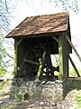
Belfry in Wamckow

Tower with a stork's nest in Wamckow

Swiss ambulance in the Mecklenburg Carriage Museum


Personalities associated with the place
- Elisabeth Hillebrandt (1886 – after 1930), writer
- Anny Funke-Schmidt (1904–1967), vocational school teacher and sculptor in Braunschweig
- Rethmann family (1994– )
swell
Printed sources
- Mecklenburg record book (MUB)
- Mecklenburg Yearbooks (MJB)
Unprinted sources
-
State Main Archive Schwerin (LHAS)
- LHAS 5.12-3 / 1 Mecklenburg-Schwerin Ministry of the Interior. No. 23469 Construction of a secondary road from Wamckow via Dessin to Parchim-Sternberger Chaussee near Turloff, 1904–1923.
- LHAS 5.12-4 / 3 Ministry of Agriculture, Domains and Forests, Settlement Department. No. 3571 Ritterschaftliches Landgut Wamckow, 1934–1944, 1946–1949.
- District archive Northwest Mecklenburg
- Council of the District of Wismar, No. I / 2739, 155th Council meeting on October 10, 1951. Resolution: establishment of a third classroom in the Wamckow school.
literature
- Peter Mugay: Wamckow, a Mecklenburg Gutsdorf through the ages. Selm 2001.
- Hans-Heinrich Schütt: On shield and seal. Schwerin 2002 ISBN 3-933781-21-3 pp. 121-122.
- Karl-Heinz Steinbruch: Kobrow. In: SVZ, Mecklenburg-Magazin 2007, No. 49, p. 26.
- Tilo Schöfbeck: The Land of Sternberg in the Middle Ages (7th – 13th centuries). Genesis of a cultural landscape in the Warnower area. In: Slavs and Germans in the High Middle Ages east of the Elbe. Volume 8, Studies in the Archeology of Europe. Bonn 2008 ISBN 978-3-7749-3485-6
Web links
Individual evidence
- ↑ Statistisches Amt MV - population status of the districts, offices and municipalities 2019 (XLS file) (official population figures in the update of the 2011 census) ( help ).
- ↑ § 8 of the main statutes ( Memento of the original from January 16, 2017 in the Internet Archive ) Info: The archive link was inserted automatically and has not yet been checked. Please check the original and archive link according to the instructions and then remove this notice. (PDF; 1.4 MB) of the community
- ↑ MUB V. (1869) No. 3163.
- ↑ MUB VII. (1872) No. 4582.
- ↑ MUB VIII. (1873) No. 5411.
- ↑ MUB II. (1864) No. 745.
- ↑ MUB II. (1864) No. 935.
- ↑ MUB II. (1864) No. 983.
- ↑ MUB V. (1869) No. 3468, 3469.
- ↑ MUB II. (1864) No. 770.
- ^ Anton von Bülow: Life and Hunting. Design. Munich-Solln 1957, p. 7.
- ↑ Horst Alsleben : Connection to the monastery remains. Today the Diakoniewerk looks after the people living here in the manor house. SVZ, Anzeiger für Sternberg-Brüel-Warin, January 7, 1999.
- ↑ Hans-Heinz Schütt: On shield and flag - the coats of arms and flags of the state of Mecklenburg-Western Pomerania and its municipalities . Ed .: production office TINUS; Schwerin. 2011, ISBN 978-3-9814380-0-0 , pp. 199 .
- ↑ a b main statute § 1 (PDF).

Alt Krenzlin | Old Zachun | Balow | Bandenitz | Banzkow | Barkhagen | Barnin | Belsch | Bengerstorf | Possession | Blankenberg | Blievenstorf | Bobzin | Boizenburg / Elbe | Borkow | Brahlstorf | Brenz | Bresegard at Eldena | Bresegard near Picher | Bruel | Brunow | Bülow | Cambs | Crivitz | Dabel | Dambeck | Demes | Dersenow | Dobbertin | Dobin at the lake | Dömitz | Domsühl | Dumber | Eldena | Friedrichsruhe | Gallin | Gallin Cupcentess | Gammelin | Ganzlin | Gehlsbach | Gneven | Göhlen | Goldberg | Gorlose | Grabow | Granzin | Grebs-Niendorf | Greetings | Greven | Great Godems | Big stuff | Groß Laasch | Hagenow | Hohen Pritz | Holthusen | Hoort | Hülseburg | Parental leave | Karrenzin | Karstädt | Church of Jesar | Klein Rogahn | Tempzin Monastery | Kobrow | Kogel | Circling | Kremmin | Kritzow | Kuhlen-Wendorf | Cow peat | Langen Brütz | Leezen | Lewitzrand | Luebesse | Lueblow | Lübheen | Luebz | Ludwigslust | Lüttow-Valluhn | Malk Göhren | Malliss | Mestlin | Milow | Möllenbeck | Moraas | Muchow | Mustin | New Gülze | New Kaliss | New Poserin | Neustadt-Glewe | Nostorf | Upper Warnow | Pampow | Parchim | Passow | Pätow-Steegen | Picher | Pinnow | Plate | Plau am See | Prislich | Pritzier | Raben Steinfeld | Rastow | Redefin | Rome | Ruhner Mountains | Lap in | Schwanheide | Siggelkow | Spornitz | Sternberg | Stumble | Stralendorf | Straw churches | Sukow | Sülstorf | Techentin | Teldau | Ticino | Toddin | Tramm | Uelitz | Vellahn | Vielank | Warlitz | Warlow | Warsow | Weitendorf | Werder | Wittenburg | Wittendbod | Wittenförden | Witch | Wöbbelin | Zapel | Zarrentin am Schaalsee | Ziegendorf | Zierzow | Zölkow | Zulow