Kladrum (Schwanheide)
Kladrum (also Cladrum , Kladrem , Kladram ) is the name of a village in the municipality of Schwanheide in Mecklenburg-Western Pomerania that died in the late Middle Ages . The name is made up of the Old Slavic word stems klaba for "tree" and rąb for "cut, felling" and means "lumberjack place".
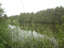
The village was about 1.5 km south of Schwanheide on the right bank of the Mühlenbach, which was dammed up here to form a pond. In 1444 the village was first mentioned as Kladrem in a document from Heinrich the Dicken . In 1458 there were two farms in addition to Kathen in addition to a mill, and from 1459 to 1468 a farmer is listed next to the miller. In contrast, a von Cladrem is recorded in neighboring Zweedorf in 1462 . After all, in 1485 only the mill itself is still inhabited. This so-called Claren mill was burned down in 1625 in the course of the Thirty Years War, but was rebuilt in 1648 and henceforth known as Schwanheider mill. Here the farmers of the Heidedörfer Bickhusen , Nostorf , Rensdorf and Zweedorf had to pay. Mill operations were stopped in the 1960s. After a renovation, the remaining building is now used as a bat habitat.
The field marrow of the village was comparatively small and bordered Nostorf in the south and Zweedorf in the west. Accordingly, it was cultivated in 1538 by three farmers from Nostorf and one from Zweedorf. In 1660 the field mark was placed at the grand ducal dairy farm in Schwanheide. In the 1890s, a late Bronze Age urn grave field was found some 100 m west of the village as part of gravel mining.
In the Schmettauschen map from 1788, the field name Wende Bruch is shown adjacent to the village , so that in connection with the name and the small size of the village and the field, a Wendish village can be assumed.
The settlement of the village long after 1252 and the transfer of the Feldmark to the Meierhof in Schwanheide speak against the assumption, which has been expressed on various occasions, that there was a name-giving association with another village to later become Zweedorf .
Individual evidence
- ^ Paul Kühnel: The Slavic place names in Meklenburg. In: Yearbooks of the Association for Mecklenburg History and Archeology. Vol. 46, 1881, ISSN 0259-7772 , pp. 3-168, here pp. 68, 70 online .
- ↑ Greve refers to the stems clodene and ramme , but arrives at the same meaning. Dieter Greve: Field name atlas for southern western Mecklenburg. Volume 1: City of Boizenburg, villages of the Boizenburg-Land office. Part 1. Thomas Helms, Schwerin 2011, ISBN 978-3-940207-25-8 , pp. 83 and 167.
- ↑ Boizenburg lease and bed register from 1458, quoted from Franz Schildt: The submerged villages of Mecklenburg-Schwerins. In: Yearbooks of the Association for Mecklenburg History and Archeology. Vol. 56, 1891, pp. 149-222, here p. 153, online .
- ↑ Werner Felten: The personal names of the city and the country Boizenburg from the 13th to the 17th century. In: Mecklenburgische Jahrbücher. Vol. 100, 1936, ISSN 0930-8229 , pp. 1-178, here p. 138 online .
- ↑ Boizenburger Bederegister from 1538, quoted from Franz Schildt: The submerged villages of Mecklenburg-Schwerins. In: Yearbooks of the Association for Mecklenburg History and Archeology. Vol. 56, 1891, pp. 149-222.
- ↑ Landbederegister from 1660, quoted from Franz Schildt: Die Untergoenen Dörfer Mecklenburg-Schwerins. In: Yearbooks of the Association for Mecklenburg History and Archeology. Vol. 56, 1891, pp. 149-222, here p. 155.
- ↑ Robert Beltz : The grave fields of the older Iron Age in Mecklenburg. In: Yearbooks of the Association for Mecklenburg History and Archeology. Vol. 71, 1906, pp. 1–152, here p. 70 f. online .
- ↑ For the methodological admissibility of this classification see Kerstin Kirsch: Slawen und Deutsche in der Uckermark. Comparative studies on the development of settlements from the 11th to the 14th century (= research on the history and culture of Eastern Central Europe. Vol. 21). Steiner, Stuttgart 2004, ISBN 3-515-08604-8 , p. 68 online .
- ^ Ina Kahns: On the folklore of the state of Mecklenburg using the example of the old Boizenburg office at the beginning of the 20th century (= publications by the Research Center for Central Europe at the University of Dortmund. Series B, No. 32). University of Dortmund - Research Center for East Central Europe, Dortmund 1983, ISBN 3-923293-02-X , p. 8; Dieter Greve: Field name atlas for southern western Mecklenburg. Volume 1: City of Boizenburg, villages of the Boizenburg-Land office. Part 1. Thomas Helms, Schwerin 2011, ISBN 978-3-940207-25-8 , pp. 83 and 167.
Coordinates: 53 ° 25 ′ 10 ″ N , 10 ° 40 ′ 21 ″ E
