
Panting
| coat of arms | Germany map | |
|---|---|---|

|
Coordinates: 53 ° 40 ′ N , 10 ° 37 ′ E |
|
| Basic data | ||
| State : | Schleswig-Holstein | |
| Circle : | Duchy of Lauenburg | |
| Office : | Secondary sand nuts | |
| Height : | 20 m above sea level NHN | |
| Area : | 13.83 km 2 | |
| Residents: | 654 (Dec. 31, 2019) | |
| Population density : | 47 inhabitants per km 2 | |
| Postal code : | 23896 | |
| Primaries : | 04542, 04543 | |
| License plate : | RZ | |
| Community key : | 01 0 53 097 | |
| LOCODE : | DE 55X | |
| Office administration address: | Am Amtsgraben 4 23898 Sandesneben |
|
| Website : | ||
| Mayor : | Thorsten Mensing (WP) | |
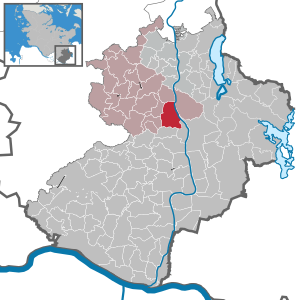
| Location of the municipality of Panten in the Duchy of Lauenburg | ||
  |
||

Panten is a municipality in the Duchy of Lauenburg in Schleswig-Holstein, east of Hamburg . Hammer and Mannhagen belong to the community.
history
To the northeast of the hamlet of Hammer are the remains of a Slavic castle ramparts , probably from the 9th century , directly on the Elbe-Lübeck Canal on the Timmermannsberg . Although the ring wall only has a diameter of 90 meters, it is said to have been the main Abodrite castle for the Lauenburg settlement area. In the 10th century at the latest, the castle was abandoned together with other fortifications, such as the ring wall in Farchau , in favor of a new main castle in Ratzeburg . The castle wall is popularly known as the stone castle.
The place is mentioned for the first time in 1158 in a document from Henry the Lion . The community was Mecklenburg until the Greater Hamburg Act of 1937 (exclave of Mecklenburg-Strelitz) and then came to the then Prussian province of Schleswig-Holstein . On April 1, 1938, Mannhagen and Hammer merged under the name Mannhagen .
In Mannhagen, copper hammers were operated by up to three water mills on the Steinau in the Middle Ages and in the early modern period . The Leers family, based in Lübeck and Mecklenburg, also owned the mills . The Mannhagener Mühle east of the village can still be seen today.
There was a brick factory in Hammer. After the building was demolished and the chimney blown up in 1972, the site was transformed into a holiday complex.
The community name was changed from Mannhagen to Panten on September 19, 1938 , because the NSDAP district leadership wanted the community name to coincide with that of the local NSDAP group . From 1948 to 1963, the municipal council made repeated attempts to reintroduce the original municipality name, but each time it failed due to bureaucratic obstacles.
The nature reserve Pantener Moorweiher and the surrounding area was designated in 1996.
coat of arms
Blazon : “Split by blue and red by a shield-shaped, overturned golden tip, inside three eight-pointed green stars placed 1: 2, a left-turned, green-clad half-shepherd who holds a black horn in his left hand and a black mallet in his right . "
Web links
Individual evidence
- ↑ North Statistics Office - Population of the municipalities in Schleswig-Holstein 4th quarter 2019 (XLSX file) (update based on the 2011 census) ( help on this ).
- ↑ Schleswig-Holstein topography. Vol. 7: Munkbrarup - Pohnsdorf . 1st edition Flying-Kiwi-Verl. Junge, Flensburg 2006, ISBN 978-3-926055-88-0 , p. 327 ( dnb.de [accessed on July 22, 2020]).
- ↑ Fred Ruchhöft: From the Slavic tribal area to the German bailiwick. The development of the territories in Ostholstein, Lauenburg, Mecklenburg and Western Pomerania in the Middle Ages (= archeology and history in the Baltic Sea area. Vol. 4). Leidorf, Rahden (Westphalia) 2008, ISBN 978-3-89646-464-4 , p. 69.
- ↑ lauenburg
- ↑ Naturraum Steinau ( Memento of the original from December 22nd, 2015 in the Internet Archive ) Info: The archive link was inserted automatically and has not yet been checked. Please check the original and archive link according to the instructions and then remove this notice.
- ↑ Peter Juers: Seizure of power on installments. How the Vogtei Mannhagen went under. in: Lauenburgische Heimat n. F., Ratzeburg 2002.
- ↑ Schleswig-Holstein's municipal coat of arms
Albsfelde | Alt-Mölln | Aumühle | Bäk | Blue | Basedow | Basthorst | Behlendorf | Berkenthin | Besenthal | Bliestorf | Exchanges | Borstorf | Breitenfelde | Bröthen | Brunsmark | Brunstorf | Books | Buchholz | Buchhorst | Dahmker | Dalldorf | Dassendorf | Düchelsdorf | Duvensee | Single house | Elmenhorst | Escheburg | Fitzen | Fredeburg | Fuhlenhagen | Geesthacht | Giesensdorf | Göldenitz | Goddess | Grabau | Grambek | Grinau | Big floor | Great Disnack | Groß Grönau | Great Pampau | Great Sarau | Groß Schenkenberg | Grove | Gudow | Gülzow | Bream | Hamfelde | Hamwarde | Harmsdorf | Havekost | Hohenhorn | Hollenbek | Hornbek | Horst | Juliusburg | Kankelau | Kasseburg | Kastorf | Kittlitz | Klein Pampau | Klein reveler | Plumbing | Klinkrade | Koberg | Kollow | Koethel | Kröppelshagen-Fahrendorf | Krukow | Curved mass | Krüzen | Kuddewörde | Killing | Kulpin | Labenz | Langenlehsten | Lankau | Lance | Lauenburg / Elbe | Clay wheel | Linau | Lüchow | Lütau | Mechow | Möhnsen | Mölln | Mill wheel | Must | Mustin | Niendorf ad St. | Niendorf near Berkenthin | Nuts | Panting | Pogeez | Poggensee | Ratzeburg | Ritzerau | Römnitz | Rondeshagen | Roseburg | Sahms | Salem | Sandesneben | Schiphorst | Schmilau | Schnakenbek | Schoenberg | Schretstaken | Schulendorf | Poking soles | Schwarzenbek | Seedorf | Seven trees | Seven oaks | Sierksrade | Sirksfelde | Steinhorst | Sterley | Stump | Talkau | Tramm | Walksfelde | Wangelau | Wentorf (Amt Sandesneben) | Wentorf near Hamburg | Wiershop | Witzeeze | Wohltorf | Woltersdorf | Worth | Ziethen
Community-free area in the Duchy of Lauenburg
Sachsenwald district