
Grambek
| coat of arms | Germany map | |
|---|---|---|

|
Coordinates: 53 ° 34 ' N , 10 ° 41' E |
|
| Basic data | ||
| State : | Schleswig-Holstein | |
| Circle : | Duchy of Lauenburg | |
| Office : | Breitenfelde | |
| Height : | 28 m above sea level NHN | |
| Area : | 12.66 km 2 | |
| Residents: | 492 (Dec. 31, 2019) | |
| Population density : | 39 inhabitants per km 2 | |
| Postal code : | 23883 | |
| Area code : | 04542 | |
| License plate : | RZ | |
| Community key : | 01 0 53 037 | |
| LOCODE : | DE 53D | |
| Office administration address: | Wasserkrüger Weg 16 23879 Mölln |
|
| Website : | ||
| Mayor : | Christian Ries (UWG) | |
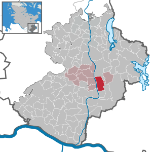
| Location of the community of Grambek in the Duchy of Lauenburg | ||
  |
||

Grambek is a municipality in the Duchy of Lauenburg in Schleswig-Holstein on the east side of the Elbe-Lübeck Canal . She belongs to the Breitenfelde office . Grambek has no other districts.
history
The village was first mentioned in a document as Grambeke in Isfried's partition contract of 1194 . The farming village belonged to the Gudow estate until 1808 , which was restored in 1815. In 1889, with the abolition of the lordly police authority by Prussia, the Gudow district was established, to which Grambek belonged again from 1948. The Gudow Office was merged with the Sterley Office to Gudow-Sterley Office in 1971 . With the dissolution of the Gudow-Sterley office, the community joined the Breitenfelde office on January 1, 2007 .
politics
Community representation
Of the nine seats in the municipal council, the UWG community of voters has six seats since the 2018 local elections and the AFWG three.
coat of arms
Blazon : "In gold, a blue arched beam tapering towards the shield head, above a blue otter with a silver patch on the chest, below two fan-shaped red heather carnations."
economy
The ponds created by gravel mining have been used for pond management since the 1950s.
Attractions
The list of cultural monuments in Grambek includes the cultural monuments entered in the list of monuments of Schleswig-Holstein.
leisure
1960 originated on former arable land of the airfield Grambeker Heide and motocross -Platz Grambeker Heidering . In 2010 the LSV Grambeker Heide and the Berlin air sports club Lilienthal celebrated the 50th anniversary of their airfield.
There is a golf course in the municipality.
Web links
Individual evidence
- ↑ North Statistics Office - Population of the municipalities in Schleswig-Holstein 4th quarter 2019 (XLSX file) (update based on the 2011 census) ( help on this ).
- ↑ Schleswig-Holstein topography. Vol. 3: Ellerbek - Groß Rönnau . 1st edition Flying-Kiwi-Verl. Junge, Flensburg 2003, ISBN 978-3-926055-73-6 , p. 283 ( dnb.de [accessed April 26, 2020]).
- ^ Department of Breitenfelde: Community representative. Retrieved July 25, 2018 .
- ↑ Schleswig-Holstein's municipal coat of arms
Albsfelde | Alt-Mölln | Aumühle | Bäk | Blue | Basedow | Basthorst | Behlendorf | Berkenthin | Besenthal | Bliestorf | Exchanges | Borstorf | Breitenfelde | Bröthen | Brunsmark | Brunstorf | Books | Buchholz | Buchhorst | Dahmker | Dalldorf | Dassendorf | Düchelsdorf | Duvensee | Single house | Elmenhorst | Escheburg | Fitzen | Fredeburg | Fuhlenhagen | Geesthacht | Giesensdorf | Göldenitz | Goddess | Grabau | Grambek | Grinau | Big floor | Great Disnack | Groß Grönau | Great Pampau | Great Sarau | Groß Schenkenberg | Grove | Gudow | Gülzow | Bream | Hamfelde | Hamwarde | Harmsdorf | Havekost | Hohenhorn | Hollenbek | Hornbek | Horst | Juliusburg | Kankelau | Kasseburg | Kastorf | Kittlitz | Klein Pampau | Klein reveler | Plumbing | Klinkrade | Koberg | Kollow | Koethel | Kröppelshagen-Fahrendorf | Krukow | Curved mass | Krüzen | Kuddewörde | Killing | Kulpin | Labenz | Langenlehsten | Lankau | Lance | Lauenburg / Elbe | Clay wheel | Linau | Lüchow | Lütau | Mechow | Möhnsen | Mölln | Mill wheel | Must | Mustin | Niendorf ad St. | Niendorf near Berkenthin | Nuts | Panting | Pogeez | Poggensee | Ratzeburg | Ritzerau | Römnitz | Rondeshagen | Roseburg | Sahms | Salem | Sandesneben | Schiphorst | Schmilau | Schnakenbek | Schoenberg | Schretstaken | Schulendorf | Poking soles | Schwarzenbek | Seedorf | Seven trees | Seven oaks | Sierksrade | Sirksfelde | Steinhorst | Sterley | Stump | Talkau | Tramm | Walksfelde | Wangelau | Wentorf (Amt Sandesneben) | Wentorf near Hamburg | Wiershop | Witzeeze | Wohltorf | Woltersdorf | Worth | Ziethen
Community-free area in the Duchy of Lauenburg
Sachsenwald district