
Wentorf (Sandesneben Office)
| coat of arms | Germany map | |
|---|---|---|

|
Coordinates: 53 ° 41 ′ N , 10 ° 28 ′ E |
|
| Basic data | ||
| State : | Schleswig-Holstein | |
| Circle : | Duchy of Lauenburg | |
| Office : | Secondary sand nuts | |
| Height : | 60 m above sea level NHN | |
| Area : | 4.99 km 2 | |
| Residents: | 732 (Dec. 31, 2019) | |
| Population density : | 147 inhabitants per km 2 | |
| Postal code : | 23898 | |
| Area code : | 04536 | |
| License plate : | RZ | |
| Community key : | 01 0 53 130 | |
| LOCODE : | DE WTO | |
| Office administration address: | Am Amtsgraben 4 23898 Sandesneben |
|
| Website : | ||
| Mayoress : | Nicole Demir | |
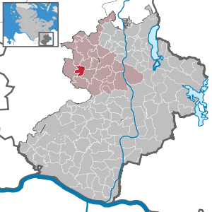
| Location of the municipality of Wentorf (Sandesneben office) in the Duchy of Lauenburg district | ||
 _in_RZ.svg) |
||

Wentorf (Office Sandesneben) (also Wentorf AS in the main municipal statute ) is a municipality in the Office Sandesneben-Nusse ( Duchy of Lauenburg district ) in Schleswig-Holstein .
location
The community is located about 35 km northeast of Hamburg. The national road 200 through the village Wentorf and flows to the northwest in the L 92nd
In addition to Wentorf, there are the towns of Bullenhorst, Hege and Schüttenmoor.
history
The place was mentioned for the first time in 1423 as "Wentorpen" in a Luebian document, but, as excavations show, it was already settled in the Neolithic , the Bronze and Iron Ages.
After the design of the village green of Wentorf, six larger agricultural properties have been dominant since the 17th century. It was only in the 19th century that notable craftsmen and new residents began to appear.
coat of arms
The local coat of arms was created in 1982. The green of the coat of arms indicates the wooded location. The catch of the eagle, which symbolically holds the prehistoric ax, shows that people lived in Wentorf in all epochs of prehistory.
Blazon : "In green, protruding from the upper edge of the shield, a black armored golden eagle's claw holding a silver Neolithic battle ax without a handle."
Others
The community center “Dörphus up den Ruhm”, built in 2003, houses the volunteer fire brigade and the community's own children's play area as well as a community hall and is the center of public and cultural life.
Web links
Individual evidence
- ↑ North Statistics Office - Population of the municipalities in Schleswig-Holstein 4th quarter 2019 (XLSX file) (update based on the 2011 census) ( help on this ).
- ↑ a b Schleswig-Holstein topography. Vol. 10: Timmaspe - Ziethen . 1st edition Flying-Kiwi-Verl. Junge, Flensburg 2008, ISBN 978-3-926055-92-7 , p. 216 ( dnb.de [accessed on August 9, 2020]).
- ^ Wentorf community - history
- ↑ Schleswig-Holstein's municipal coat of arms
Albsfelde | Alt-Mölln | Aumühle | Bäk | Blue | Basedow | Basthorst | Behlendorf | Berkenthin | Besenthal | Bliestorf | Exchanges | Borstorf | Breitenfelde | Bröthen | Brunsmark | Brunstorf | Books | Buchholz | Buchhorst | Dahmker | Dalldorf | Dassendorf | Düchelsdorf | Duvensee | Single house | Elmenhorst | Escheburg | Fitzen | Fredeburg | Fuhlenhagen | Geesthacht | Giesensdorf | Göldenitz | Goddess | Grabau | Grambek | Grinau | Big floor | Great Disnack | Groß Grönau | Great Pampau | Great Sarau | Groß Schenkenberg | Grove | Gudow | Gülzow | Bream | Hamfelde | Hamwarde | Harmsdorf | Havekost | Hohenhorn | Hollenbek | Hornbek | Horst | Juliusburg | Kankelau | Kasseburg | Kastorf | Kittlitz | Klein Pampau | Klein reveler | Plumbing | Klinkrade | Koberg | Kollow | Koethel | Kröppelshagen-Fahrendorf | Krukow | Curved mass | Krüzen | Kuddewörde | Killing | Kulpin | Labenz | Langenlehsten | Lankau | Lance | Lauenburg / Elbe | Clay wheel | Linau | Lüchow | Lütau | Mechow | Möhnsen | Mölln | Mill wheel | Must | Mustin | Niendorf ad St. | Niendorf near Berkenthin | Nuts | Panting | Pogeez | Poggensee | Ratzeburg | Ritzerau | Römnitz | Rondeshagen | Roseburg | Sahms | Salem | Sandesneben | Schiphorst | Schmilau | Schnakenbek | Schoenberg | Schretstaken | Schulendorf | Poking soles | Schwarzenbek | Seedorf | Seven trees | Seven oaks | Sierksrade | Sirksfelde | Steinhorst | Sterley | Stump | Talkau | Tramm | Walksfelde | Wangelau | Wentorf (Amt Sandesneben) | Wentorf near Hamburg | Wiershop | Witzeeze | Wohltorf | Woltersdorf | Worth | Ziethen
Community-free area in the Duchy of Lauenburg
Sachsenwald district