
Bröthen
| coat of arms | Germany map | |
|---|---|---|

|
Coordinates: 53 ° 29 ′ N , 10 ° 40 ′ E |
|
| Basic data | ||
| State : | Schleswig-Holstein | |
| Circle : | Duchy of Lauenburg | |
| Office : | Books | |
| Height : | 23 m above sea level NHN | |
| Area : | 10.69 km 2 | |
| Residents: | 311 (Dec. 31, 2019) | |
| Population density : | 29 inhabitants per km 2 | |
| Postal code : | 21514 | |
| Area code : | 04155 | |
| License plate : | RZ | |
| Community key : | 01 0 53 015 | |
| LOCODE : | DE OTX | |
| Office administration address: | Amtsplatz 1 21514 Büchen |
|
| Website : | ||
| Mayor : | Walter Burmester | |
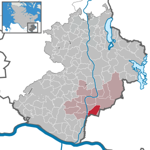
| Location of the municipality of Bröthen in the Duchy of Lauenburg | ||
  |
||

Bröthen is a municipality in the Duchy of Lauenburg in Schleswig-Holstein .
geography
The community borders in the south on the federal state Mecklenburg-Western Pomerania , in the east and north on the community Langenlehsten and in the west on the communities Büchen and Witzeeze .
The brook Riedebeck rises in the municipality of Bröthen and forms the border with Mecklenburg-Western Pomerania in the southwest, while the Delvenau is the border river Bröthen in the west. Bröthen extends in the northeast into the Bergholzer Forest .
history
The place Bröthen was first mentioned in the Ratzeburg tithe register of 1230 as Brotne (Slavic = ford ) as part of the Büchen church play. The place was created by originally two Slavic settlements on the Riedebek.
Only a few documents are available for the subsequent period. It is possible that today's municipal area was desolate for decades after the Thirty Years' War until the place was rebuilt at its current location.
The Bröthener citizens were partly Lauenburg official citizens, partly belonging to Gut Gudow. Ecclesiastically they all belonged to the Büchen parish.
With the introduction of the definition of the municipality by Prussia at the beginning of the 1870s, the Niebuhr sluice on the Delvenau-Stecknitz canal came to the municipality with a pub. In the second half of the 19th century, the canal increasingly lost its importance due to the expansion of the railway network. The construction of the Elbe-Lübeck Canal from 1896 did not affect Bröthen. It was not until 1926 that the road from Bröthen to Büchen was expanded.
At the end of and after the Second World War , the number of inhabitants reached its previous maximum. In 1950, 312 people lived in Bröthen.
From 1945 to 1989 Bröthen was a border town on the Iron Curtain .
On the night of May 1, 1976, Michael Gartenschläger while trying to spring guns of the type SM-70 to dismantle at the border, shot near Bröthens.
More than 20 years after the opening of the border, there is still no direct road connection to the neighboring town of Schwanheide .
nature
The Stecknitz-Delvenau-Niederung nature reserve is located on the edge of the Bröthen municipality. With the exception of the extreme south, Bröthen is part of the Lauenburg Lakes Nature Park .
In recent years, parts of the community have been renatured . This created wetlands and heathland, and animal and plant species such as the gray shrike or the wasp spider were preserved.
Web links
Individual evidence
- ↑ North Statistics Office - Population of the municipalities in Schleswig-Holstein 4th quarter 2019 (XLSX file) (update based on the 2011 census) ( help on this ).
Albsfelde | Alt-Mölln | Aumühle | Bäk | Blue | Basedow | Basthorst | Behlendorf | Berkenthin | Besenthal | Bliestorf | Exchanges | Borstorf | Breitenfelde | Bröthen | Brunsmark | Brunstorf | Books | Buchholz | Buchhorst | Dahmker | Dalldorf | Dassendorf | Düchelsdorf | Duvensee | Single house | Elmenhorst | Escheburg | Fitzen | Fredeburg | Fuhlenhagen | Geesthacht | Giesensdorf | Göldenitz | Goddess | Grabau | Grambek | Grinau | Big floor | Great Disnack | Groß Grönau | Great Pampau | Great Sarau | Groß Schenkenberg | Grove | Gudow | Gülzow | Bream | Hamfelde | Hamwarde | Harmsdorf | Havekost | Hohenhorn | Hollenbek | Hornbek | Horst | Juliusburg | Kankelau | Kasseburg | Kastorf | Kittlitz | Klein Pampau | Klein reveler | Plumbing | Klinkrade | Koberg | Kollow | Koethel | Kröppelshagen-Fahrendorf | Krukow | Curved mass | Krüzen | Kuddewörde | Killing | Kulpin | Labenz | Langenlehsten | Lankau | Lance | Lauenburg / Elbe | Clay wheel | Linau | Lüchow | Lütau | Mechow | Möhnsen | Mölln | Mill wheel | Must | Mustin | Niendorf ad St. | Niendorf near Berkenthin | Nuts | Panting | Pogeez | Poggensee | Ratzeburg | Ritzerau | Römnitz | Rondeshagen | Roseburg | Sahms | Salem | Sandesneben | Schiphorst | Schmilau | Schnakenbek | Schoenberg | Schretstaken | Schulendorf | Poking soles | Schwarzenbek | Seedorf | Seven trees | Seven oaks | Sierksrade | Sirksfelde | Steinhorst | Sterley | Stump | Talkau | Tramm | Walksfelde | Wangelau | Wentorf (Amt Sandesneben) | Wentorf near Hamburg | Wiershop | Witzeeze | Wohltorf | Woltersdorf | Worth | Ziethen
Community-free area in the Duchy of Lauenburg
Sachsenwald district