
Bröthen (Hoyerswerda)
Bröthen , in Upper Sorbian Brětnja , is a village in the district of Bröthen / Michalken in the Saxon major district town of Hoyerswerda in the Bautzen district . It lies in the Sorbian settlement area of Upper Lusatia .
geography

The village of Bröthen, as well as Michalken to the south-southeast of it , lies west-southwest of the old town of Hoyerswerda. Klein Neida in the east and Schwarzkollm in the west are each about three kilometers (as the crow flies) away.
South of Bröthen and a little north of the town center of Michalken, the federal road 97 coming from Hoyerswerda runs southwest through a large heathland via Neukollm to Bernsdorf .
history
Bröthen was first mentioned in 1401 as Pritthun . In 1568 the Hoyerswerda class rule exercised the basic rule . In 1895 the Bröthen district measured 932 hectares . In the GDR era, the place belonged to the Hoyerswerda district in the Cottbus district . In 1950 Bröthen and the neighboring town of Michalken merged. After reunification and reunification , the community became part of the newly founded Free State of Saxony in the district of Hoyerswerda. On July 1, 1993, it was incorporated into the town of Hoyerswerda as the district of Bröthen / Michalken . In 1996 it became a district. In the course of the district reform in Saxony , the city lost its district freedom and became part of the Bautzen district.
The inhabitants of Bröthen were originally Sorbian-speaking . According to Arnošt Muka's statistics , a total of 333 inhabitants lived here in 1884/85, 321 of them Sorbs (96%). In the mid-1950s, Ernst Tschernik determined a Sorbian-speaking population of 38.1%, including 93 Sorbian young people.

Bröthener brass musicians, 1983
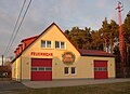
Bröthen volunteer fire brigade
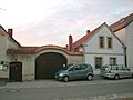
Four-sided courtyard with archway

Stone cross on Schäferweg


Web links
- Bröthen in the Digital Historical Directory of Saxony
Individual evidence
- ↑ Ernst Tschernik: The development of the Sorbian population . Akademie-Verlag, Berlin 1954.
- ^ Ludwig Elle: Language policy in the Lausitz . Domowina-Verlag, Bautzen 1995.
Coordinates: 51 ° 25 ′ 36.8 ″ N , 14 ° 10 ′ 59.1 ″ E