
Schwarzkollm
|
Schwarzkollm
Čorny Chołmc Large district town of Hoyerswerda
|
|
|---|---|
 |
|
| Height : | 124 m above sea level NN |
| Area : | 30.34 km² |
| Residents : | 792 (December 31, 2015) |
| Population density : | 26 inhabitants / km² |
| Incorporation : | January 1, 1996 |
| Postal code : | 02977 |
| Area code : | 035722 |

_2.jpg)
Schwarzkollm , Upper Sorbian , is a village in Eastern Saxony . Since January 1, 1996, the Straßenangerdorf is a district of the town of Hoyerswerda, about 10 kilometers east of it . The place is in the Sorbian settlement area in Upper Lusatia .
The place was best known for the Sorbian legend of the Krabat and the Black Mill near the settlement of Koselbruch (Kózło) . Schwarzkollm is the start and end point of the Krabat cycle path and is located in the Lauta-Hoyerswerda-Wittichenau landscape protection area ( Saxon LSG d 51).
geography
Schwarzkollm is located on the edge of the Lusatian Lakeland in a wooded landscape. Of the 3034 hectares in the district, around 2200 hectares are forested, with the pine being the most common tree. Surrounding villages are Leippe-Torno in the west, Lauta in the northwest, Laubusch in the north, Nardt and Bröthen in the east.
The federal road 97 leads between Hoyerswerda and Bernsdorf through Neukollm, a hamlet belonging to Schwarzkollm in the southern part of the district. The colonies of Koselbruch and Petzerberg are located off the road between Schwarzkollm and Neukollm. The settlements Sand Wash and Waldesruh are located directly on the Ruhland – Hoyerswerda railway line , where Schwarzkollm has a train station. To the east of the village is the 153.5 m high Steinberg, which is used as a quarry . A coarse-grained Lusatian granodiorite , usually called Lusatian granite , has been extracted in a quarry since 1882 . Other hills in the vicinity are Richtberg, Kubitzberg, and Petzerberg.
history


The village of Cholm was first mentioned in 1394. The name Schwarzkollm has been documented since 1759 and was introduced to distinguish it from the village of the same name east of Hoyerswerda, today's Weißkollm . The German place name Kollm goes back to the Sorbian, which means a place on or on a hill. Schwarzkollm has been a Kirchort since the 12th or 13th century. The originally Gothic St. Mary's Church was destroyed by fire in 1858 and rebuilt in the Romanesque style. After the eastern part of Upper Lusatia had to be ceded by Saxony to Prussia in 1815, the municipality was assigned to the district of Hoyerswerda . After the administrative reform of 1952 , which among other things resulted in the division of the district of Hoyerswerda, Schwarzkollm was assigned to the new district of Hoyerswerda .
In 1993 Schwarzkollm was awarded the golden plaque in the nationwide competition Our village should be more beautiful ; two years later it received silver.
The village has a lively club life. With the Frentzelhaus, which was expanded from a stable in 1998, a domicile was created for the local clubs. In the district of Waldesruh there is a school camp in a former inn and since 2006 a local association has been building the Krabat-Mühle adventure farm in nearby Koselbruch not far from the location of the Schwarzen Mühle , where concerts and film screenings take place.
Population development
| year | Residents |
|---|---|
| 1825 | 349 |
| 1871 | 446 |
| 1885 | 433 |
| 1905 | 680 |
| 1925 | 770 |
| 1933 | 803 |
| 1939 | 911 |
| 1946 | 912 |
| 1950 | 976 |
| 1964 | 789 |
| 1990 | 539 |
| 1994 | 574 |
| 2004 | 899 |
| 2009 | 876 |
| 2013 | 816 |
In the middle of the 16th century there were 39 possessed men and 6 gardeners and cottagers in Schwarzkollm . Around 200 years later, the total economy had risen slightly at the expense of the farmers, so during the state recession in 1777 there were 36 possessed men, 7 gardeners and 13 cottagers.
In the 19th century, the population grew from 349 in 1825 to 446 in 1871. Nevertheless, Arnošt Muka found in his studies of the Sorbian population in the mid-1880s that the population was almost entirely Sorbian. Only about three percent (14 of 438 inhabitants) were Germans.
Rapid growth did not emerge until the beginning of the 20th century, when the population had risen to 680 inhabitants in 1905 and 770 in 1925, which in a hundred-year comparison is more than double the value of 1825. Until shortly before the outbreak of the Second World War, the population had risen to 911. This level was also maintained in 1946, but due to refugees and displaced persons the number of inhabitants rose to 976 by 1950. Only then did it decline again, so that in 1964 there were fewer than 800 and in 1990 just under 550 inhabitants. As a result of urban exodus , the population rose again to over 900 over the next 15 years, but then slowly fell back to around 820 in 2013.
politics
Local partnerships
- Heinersreuth , Germany
- Stephanskirchen , Germany
coat of arms
Typical symbols of the place and the local history are united in the Schwarzkollmer coat of arms. The figure of the Krabat is taken from the Krabat legend. The mill wheel symbolizes the black mill near Koselbruch, where Krabat learned the magic trade. The four hills symbolize the four hills in the area, from which the name was once derived. The trees on these hills indicate the abundance of forests in the landscape around Schwarzkollm.
Attractions
The four-sided courtyards enclosed by archways or gatehouses are striking in the townscape .
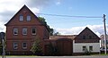
Dorfstrasse 39

Dorfstrasse 41
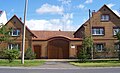
Dorfstrasse 50


Personalities
- Salomon Gottlob Frentzel (1701–1768) was born in Schwarzkollm and later was clergyman and local chronicler of the city of Hoyerswerda.
- Born in Schwarzkollmer, David Traugott Kopf (1788-1865) was a Sorbian educator who worked in Lower Lusatia and Berlin.
- The Sorbian teacher and folklorist Hendrich Jordan (1841-1910) and the German-Sorbian painter Carl Noack (1873-1959) grew up in Schwarzkollm.
Individual evidence
- ↑ Ernst Eichler , Hans Walther : Oberlausitz toponymy - studies on the toponymy of the districts of Bautzen, Bischofswerda, Görlitz, Hoyerswerda, Kamenz, Löbau, Niesky, Senftenberg, Weißwasser and Zittau. I name book (= German-Slavic research on naming and settlement history . Volume 28 ). Akademie-Verlag, Berlin 1975, p. 133 .
- ↑ a b Schwarzkollm in the Digital Historical Directory of Saxony
- ↑ hoyerswerda.de
Web links
- Website of the district of Schwarzkollm
- Portrait of Schwarzkollm on the website of the city of Hoyerswerda

Bröthen / Michalken (Brětnja / Michałki) | Dörgenhausen (Němcy) | Knappenrode (Hórnikecy) | Schwarzkollm (Čorny Chołmc) | Zeißig (CISK)