Kollm
|
Kollm
Quitzdorf am See municipality
Coordinates: 51 ° 16 ′ 0 ″ N , 14 ° 44 ′ 0 ″ E
|
|
|---|---|
| Height : | 165 m above sea level NN |
| Area : | 11.51 km² |
| Residents : | 284 (Jun. 30, 2014) |
| Population density : | 25 inhabitants / km² |
| Incorporation : | March 1, 1994 |
| Postal code : | 02906 |
| Area code : | 03588 |
|
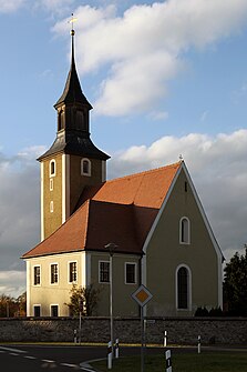
Kollm Church
|
|
Kollm ( Upper Sorbian Chołm ) is a district of the community Quitzdorf am See in the Saxon district of Görlitz .
geography
Kollm is located in the eastern part of the Upper Lusatian Heath and Pond Landscape Biosphere Reserve , southwest of the city of Niesky on the west bank of the Quitzdorf reservoir .
Surrounding places are Steinölsa in the northwest, Sproitz in the northeast, and from southeast to southwest Diehsa , Thräna and Groß Radisch .
history
Local history
Kollm was first mentioned in 1346 as "village of Kollme". The church was also built in the 14th century. The place has the form of a manor settlement with a round hamlet core and a manor block corridor of around 900 hectares.
After the cession of the eastern part of Upper Lusatia from Saxony to Prussia in 1815, Kollm was assigned to the Rothenburg district (Ob. Laus.) Founded in 1816 . In February 1874, the “ Diehsa District ” was created, which included the rural communities of Collm, Diehsa, Quitzdorf and Steinölsa and the four manor districts of the same name . The manor districts were incorporated into the rural communities until 1928. The district was dissolved in 1933 and the communities were incorporated into the surrounding districts. Kollm came with Steinölsa to the "Oelsa District", which was renamed "Weigersdorf District" in 1937.
The Sorbian scientist Arnošt Muka determined in the 1880s that the population of Kollm is made up of about 50 percent each of Sorbs and Germans. He then assigned Kollm to the central Sorbian language area. It is interesting that he did not pay much attention to the neighboring town of Quitzdorf at that time, as it was outside the Sorbian-speaking area. One of the Sorbian pastors in Kollm in the 19th century was Jan Wahoda ( Jan Łahoda ), who headed the Kollm parish from 1832 to 1871 and whose tomb is at the church.
After the administrative reform of 1952 , Kollm was assigned to the Niesky district . On March 1, 1994, the municipality of Kollm merged with Sproitz to form the municipality of Quitzdorf am See . The community seat is in Kollm.
Population development
| year | 1825 | 1871 | 1885 | 1910 | 1925 | 1933 | 1939 | 1946 | 1990 | 1993 |
|---|---|---|---|---|---|---|---|---|---|---|
| Residents | 383 | 451 | 421 | 370 | 433 | 426 | 404 | 480 | 379 | 363 |
Place name
As with Weißkollm and Schwarzkollm, the German name Kollm is derived from the Sorbian name chołm for 'hill'. So there are places on or on a hill.
In the 18th century, the two places near Hoyerswerda were given a name prefix to better differentiate them. Despite the relatively short distance to them, Kollm had been in a completely different administrative district for centuries, so that a corresponding prefix was probably not considered necessary here.
Personalities
- Felix Freiherr von Gutschmid (1843–1905), German envoy to Chile and Japan
- Walther von Miquel (1869–1945), German district president and landowner in Kollm
Sources and further reading
Web links
- Commons : Kollm - collection of images, videos and audio files
- Kollm in the Digital Historical Directory of Saxony
literature
- From the Muskauer Heide to the Rotstein. Home book of the Lower Silesian Upper Lusatia District . Lusatia Verlag, Bautzen 2006, p. 287 .
Individual evidence
- ↑ Digital historical place directory of Saxony. Retrieved August 1, 2008 .
- ↑ Saxony regional register. Retrieved August 1, 2008 .


