Knappenrode
|
Knappenrode
Hórnikecy Large district town of Hoyerswerda
Coordinates: 51 ° 24 ′ 10 ″ N , 14 ° 19 ′ 10 ″ E
|
||
|---|---|---|
| Height : | 123 m above sea level NN | |
| Area : | 9.89 km² | |
| Residents : | 705 (December 31, 2015) | |
| Population density : | 71 inhabitants / km² | |
| Incorporation : | January 1, 1994 | |
| Postal code : | 02977 | |
| Area code : | 03571 | |
|
Location of Knappenrode in Saxony |
||
Knappenrode , Upper Sorbian , is one of the youngest localities in East Saxony , which was founded in 1913 as a workers' settlement under the name Werminghoff . Since 1994 the place north of the Knappensee belongs to the city of Hoyerswerda .
geography
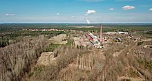
Knappenrode is located in the north-eastern part of the Bautzen district in the middle of an extensive forest area in the Lusatian lignite district . West of Knappenrode, the federal highway 96 runs through Maukendorf via Zeißig to Hoyerswerda, whose city center is about 10 kilometers northwest of Knappenrode.
The Scheibesee lies around five kilometers north of Knappenrode . The villages of Riegel , Tiegling , Weißkollm , Lohsa , Mortka and Koblenz, which belong to the municipality of Lohsa, connect in a semicircle to the south . Slightly east between Koblenz and Knappenrode the Graureihersee and west of Knappensee. The parish village of Groß Särchen is located on the opposite bank .
North-east of Knappenrode is the intersection of the Węgliniec – Falkenberg / Elster railway lines (Hoyerswerda – Niesky section) and Bautzen – Spremberg .
history
From 1910 coal fields in the Lohsa area were bought up by Eintracht Braunkohlenwerke und Briketfabriken AG (often referred to as Eintracht for short ). After clearing the corresponding forest areas, excavation began in 1913. In the same year, work began on building a briquette factory , a train station and a workers' settlement for this opencast mine . The pit, briquette factory, train station and settlement were given the name Werminghoff , named after Joseph Werminghoff , the general manager of Eintracht.

The district committee of Hoyerswerda had issued the condition to set up facilities to safeguard communal life. The school opened in 1917 and the Knappenrode volunteer fire brigade was founded in 1919 .
On January 1, 1922, Werminghoff became a rural community by order of the Liegnitz district president .
During the Second World War , the mine conveyor bridge was bombed by enemy flights on August 30, 1942 , but not damaged. From 1943 bombed families from the West and Berlin were taken in, followed by refugees from Silesia in 1944/1945 .
Already at noon on April 16, 1945, the day the Red Army crossed the Oder-Neisse , the evacuation order was given for Werminghoff. On foot, by car or by train, we went via Bernsdorf towards Dippoldiswalde . On April 17th, production in the factory was stopped. Werminghoff was taken without a fight by the 5th Soviet Guard Army and the 2nd Polish Army on April 22nd. A month later, on May 22nd, work at the factory resumed.
After the end of the Second World War, the western part of the province of Lower Silesia that remained in Germany was assigned to the state of Saxony. On January 27, 1950, the name of the municipality Werminghoff was changed to Knappenrode . As a result of the administrative reform of 1952 , Knappenrode came to the Cottbus district in the smaller Hoyerswerda district , which was to develop into an energy district within the GDR.
The Werminghoff mine, which was flooded in 1945, was expanded to include a dam on the west side in the early 1950s, creating the Knappensee . This was declared a landscape protection area on January 8, 1959 .
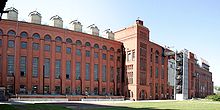
After the fall of the Wall , the briquette factory was shut down on February 25, 1993. The Lusatian Mining Museum Knappenrode emerged from it.
On January 1, 1994, Knappenrode was incorporated into Hoyerswerda.
Population development
| year | Residents |
|---|---|
| 1925 | 1243 |
| 1939 | 1046 |
| 1946 | 1249 |
| 1950 | 1330 |
| 1964 | 1502 |
| 1990 | 1043 |
| 1993 | 1000 |
| 2008 | 746 |
| 2011 | 739 |
| 2013 | 713 |
Just 12 years after the town was founded, Knappenrode had over 1200 inhabitants. Their number sank to around 1000 by the Second World War, but rose again to over 1200 towards the end of the war due to refugees. As early as 1948 the community had 1,410 inhabitants, including 409 resettlers from the former German eastern areas. Knappenrode had reached its highest population level in 1957/1958 with 1776 inhabitants. After that, the population gradually decreased, so that in 1964 around 1,500 and in 1993 still 1,000 inhabitants were counted.
After the incorporation, the population continued to decline, so that at the end of 2013 there were still a little over 700 inhabitants.
Place name
Due to its derivation from the name of a capitalist industrialist, the name Werminghoff was not compatible with the political stance in the early years of the GDR, so that it was changed to Knappenrode in 1950 . The new name refers to the history of the development of the settlement; the previously existing forest was cleared for mining (represented by the miner ) . The Sorbian name Hórnikecy is derived from the Sorbian word hórnik 'miner'.
Attractions
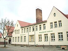
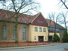
Various buildings from the time the town was founded and its growth have been designated as cultural monuments, including the briquette factory, the school building and the former restaurant.
In the Knappenrode energy factory , exhibits on the mining history of the Lusatian lignite mining area are shown.
Individual evidence
- ^ Knappenrode in the Digital Historical Directory of Saxony
- ↑ Saxony regional register. Retrieved September 29, 2008 .
- ↑ hoyerswerda.de
- ↑ Knappenrode.de: History. Retrieved May 3, 2012 .
- ^ Ernst Eichler , Hans Walther : Ortnamesbuch der Oberlausitz. Studies on the toponymy of the districts of Bautzen, Bischofswerda, Görlitz, Hoyerswerda, Kamenz, Löbau, Niesky, Senftenberg, Weißwasser and Zittau. I: Name book (= German-Slavic research on naming and settlement history . Volume 28 ). Akademie-Verlag, Berlin 1975, p. 130 .
literature
- Maximilian Claudius Noack: The miners' colony Knappenrode. In: Between Röder and Kleiner Spree ( ZDB -ID 2087541-1 ), Heft 8 (2015), pp. 54–65.
- Reinhard Specht: 100 years of lignite mining around Werminghoff (Knappenrode) and Lohsa. Oberlausitzer Verlag, Spitzkunnersdorf 2014, ISBN 978-3-941908-55-0 .
Web links
- Knappenrode.de
- Portrait of Knappenrode on the website of the city of Hoyerswerda


