
Lohsa
| coat of arms | Germany map | |
|---|---|---|

|
Coordinates: 51 ° 23 ' N , 14 ° 24' E |
|
| Basic data | ||
| State : | Saxony | |
| County : | Bautzen | |
| Height : | 114 m above sea level NHN | |
| Area : | 134.54 km 2 | |
| Residents: | 5232 (Dec. 31, 2019) | |
| Population density : | 39 inhabitants per km 2 | |
| Postal code : | 02999 | |
| Primaries : | 035724 (Dreiweibern, Driewitz, Friedersdorf, Hermsdorf / Spree, Litschen, Lohsa, Mortka, Riegel, Steinitz, Tiegeling, Weißig, Weißkollm) , 035726 (Groß Särchen, Koblenz) , 035728 (lips) | |
| License plate : | BZ, BIW, HY, KM | |
| Community key : | 14 6 25 330 | |
| Community structure: | 15 districts | |
| Address of the municipal administration: |
Am Rathaus 1 02999 Lohsa |
|
| Website : | ||
| Mayor : | Thomas Leberecht (CDU) | |
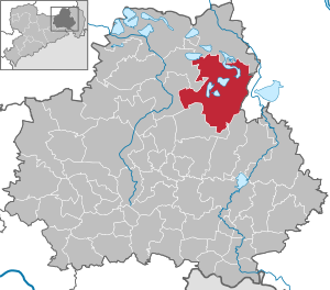
| Location of the municipality of Lohsa in the district of Bautzen | ||
  |
||


Lohsa , Upper Sorbian , is the largest municipality in the Saxon district of Bautzen in Upper Lusatia . The unitary community of Lohsa is located on the Kleine Spree , east of the cities of Wittichenau and Hoyerswerda , and is part of the official settlement area of the Sorbs .
Several lakes in the emerging Lusatian Lakeland are partly or entirely in the municipality. The Lohsa I reservoir and the Silbersee that is connected to it are the remaining holes in former open- cast lignite mines , the flooding of which began in February 1971. To the north of Lohsa, the Dreiweiberner See was created in 2001 after the Lohsa open-cast lignite mine, which was closed in 1989, was flooded. To the east of Weißkollm, there is another open-cast mine, the Lohsa II reservoir . To the south of the former district of Bärwalde , a short distance from the municipality boundary, the Bärwalder See follows .
Local division
The following 15 districts belong to the unitary community of Lohsa:
- Three women (Tři Žony) ; 37 inhabitants
- Driewitz (Drěwcy) ; 113 inhabitants
- Friedersdorf (Bjedrichecy ; with Womjatke, also referred to as Neu Friedersdorf); 186 inhabitants
- Big Särchen (Wulke Ždźary) ; 1,120 inhabitants
- Hermsdorf / Spree (Hermanecy) ; 184 inhabitants
- Koblenz (Koblicy) ; 381 inhabitants
- Lips (lipiny) ; 59 inhabitants
- Litschen (Złyčin) ; 275 inhabitants
- Lohsa (Łaz) ; 1,596 inhabitants
- Mortka (Mortkow ; renamed Grube Ostfeld from November 30, 1936 to 1947 ); 152 inhabitants
- Riegel (Roholń) ; 105 inhabitants
- Steinitz (Šćeńca ; with Kolbitz and Neu Steinitz); 304 inhabitants
- Tiegling (Tyhelc) ; 57 inhabitants
- Whitish (Wysoka) ; 71 inhabitants
- Weißkollm (Běły Chołmc) ; 716 inhabitants
The population figures for the individual places come from the Lohsa registration office (as of December 31, 2016) and, due to different calculation rules, show a total deviation from the population figures of the municipalities published by the State Statistical Office of the Free State of Saxony.
Due to the lignite mining, the following villages have been partially or completely devastated on today's municipal corridors :
- Buchwalde (1926–1932),
- Three women (partly, 1985),
- Geißlitz (1960),
- Kolpen (1960),
- Lips (partially, 1960–1961),
- Neida ( renamed Köhlergrund from 1936 to 1947 , demolished 1951–1952),
- New Lohsa (1943–1947),
- Ratzen (1960),
- Disk (1984),
- Ziegenpfauze (1955).
history


The place Lohsa was first mentioned in 1343 under the name "Lose". The Lohsa church was first mentioned in a document in 1346, making it one of the oldest churches in northern Upper Lusatia. The Lohsaer Gut is mentioned for the first time in 1350 as the property of the von Pannewitz and Schreibersdorf in the Neschwitz rule. In 1470, Balthaser von Schreibersdorf is named as the owner of Lohsa, Friedersdorf and Weißkollm. In 1523 Bernhard von Gersdorf purchased the Lohsa estate. In 1547 Christoph von Schreibersdorf zu Lohsa bought the villages of Litschen, Driewitz and Lips. From the end of the 16th to the middle of the 17th century, Gut Lohsa changed hands several times.
On October 19, 1991, the Foundation for the Sorbian People was established in the Protestant Church of Lohsa in the presence of Prime Ministers Kurt Biedenkopf and Manfred Stolpe and the Federal Minister for Women and Youth Angela Merkel .
Incorporations
Dreiweibern and Ratzen have been part of Lohsa since 1938. In 1994 five municipalities were incorporated, of which Bärwalde was reclassified to Boxberg / OL in 1998 . Lips moved from Uhyst to Lohsa in 1996 . The municipality of Knappensee , which was newly formed in 1995 , was dissolved in 2005. Your districts of Groß Särchen and Koblenz came to Lohsa.
| Former parish | date | annotation |
|---|---|---|
| Bärwalde | January 1, 1957 January 1, 1978 January 1, 1994 January 1, 1998 |
Incorporation to Merzdorf, outsourcing from Merzdorf, incorporation to Lohsa, reclassification to Boxberg / OL |
| Threesomes | April 1, 1938 | |
| Driewitz | January 1, 1957 | Incorporation after Litschen |
| Friedersdorf | January 1, 1957 | Incorporation after Litschen |
| Big Särchen | October 1, 1995 January 1, 2005 |
Incorporation to Knappensee, reclassification to Lohsa |
| Hermsdorf / Spree | January 1, 1994 | |
| Knappensee | January 1, 2005 | Incorporation to Lohsa and Königswartha |
| Koblenz | October 1, 1995 January 1, 2005 |
Incorporation to Knappensee, reclassification to Lohsa |
| Lips | May 1, 1974 January 1, 1996 |
Incorporation to Uhyst, reclassification to Lohsa |
| Litschen | January 1, 1994 | |
| Mortka | January 1, 1957 | Incorporation after Litschen |
| Ratz | April 1, 1938 | |
| bars | January 1, 1978 | Incorporation to Weißkollm |
| disc | April 1, 1938 | Incorporation after Riegel |
| Steinitz | January 1, 1994 | |
| Whitish | April 1, 1938 1945 1948 |
Incorporation to Hermsdorf / Spree, reclassification to Steinitz, reclassification to Hermsdorf / Spree |
| Weißkollm | January 1, 1994 |
Population and language
For his statistics on the Sorbian population in Upper Lusatia, Arnošt Muka determined a population of 467 in the 1880s, including 432 Sorbs (93%) and 35 Germans. In 1956 Ernst Tschernik counted a Sorbian-speaking population of only 37.3% in the municipality of Lohsa with rats and three women. Since then, the use of Sorbian has continued to decline in the village.
politics
Municipal council
Since the municipal council election on May 26, 2019 , the 19 seats of the municipal council have been distributed among the individual groups as follows:
- CDU : 8 seats
- LEFT : 2 seats
- Voters' association for the unified community Lohsa (WVE): 4 seats
- Free voters Knappensee (FWK): 3 seats
- AfD : 2 seats
Municipal coat of arms
Lohsa has had a coat of arms since 1992. Meaning: Lohsa used to be a place surrounded by swamps (green wavy line). Originally, the citizens made their living mainly from fishing (blue fish). Mining has shaped the landscape since 1935 ( mallets and irons ). Today, in the field of landscape, environmental and nature conservation, great efforts are made to protect existing natural monuments, to recultivate old open-cast mining areas, to enrich the place with nature and to make it part of the townscape. The Silbersee recreational area (blue wavy line) was created from the former opencast mine II of the Glückauf Knappenrode lignite works . A local recreation area is also developing at the former Dreiweibern opencast mine. Ponds created as part of the recultivation, which will again be used for fish farming and are already being prepared for this purpose (blue fish). According to Jan Meschgang's book The place names of Upper Lusatia , the Sorbian name for Lohsa Łaz means : “Settlement on new land reclaimed by clearing.” Therefore, a tree (pine) stands in the center of the coat of arms.
tourism

The community is located in the southern part of the Lusatian Lakeland , which is created from flooded open- cast mining holes . The Silbersee (Slěborny jězor; Tgb. Werminghoff II; 315 ha; 1972), directly south of Lohsa, part of the Lohsa I storage basin , is closed due to renovation work on the embankment. The Knappensee (Hórnikečanski jězor; Tgb. Werminghoff I ; 286 ha; 1953) near Groß Särchen / Koblenz will be closed in 2013 due to remedial work by the LMBV . The Dreiweiberner See (Třižonjanski jězor; Tgb. Dreiweibern; 286 ha; 2002), directly north of Lohsa, was opened in 2005. To the east of Weißkollm , the Lohsa II reservoir is being created, another open-cast mine that has not yet had a real name and is primarily used as a water reservoir.
The southern and eastern municipal area is part of the Upper Lusatian Heath and Pond Landscape Biosphere Reserve , with many ponds, a lot of forest, the otter, the wolf and many rare birds.
Economy and Infrastructure

education
The municipality of Lohsa has a primary school in Groß Särchen and a high school.
traffic
The federal highway 156 runs east of the municipality , west the B 96 , via which the northwest running B 97 can be reached. Lohsa is connected to the Niesky – Hoyerswerda (–Falkenberg (Elster) –Rosslau (Elbe)) railway with a demand stop . The RB 64 line (Hoyerswerda – Görlitz) operates here as a Seenland-Neisse shuttle .
Attractions

Buildings
- see also: List of cultural monuments in Lohsa
- Bat lock Weißig
- Evangelical Church in Lohsa
- Monument to Handrij Zejler on the market square
Museums and exhibitions
Sons and daughters of the church
- Rosemarie Ackermann (* 1952), high jumper and Olympic champion
- Martha Israel (1905–?), Sorbian member of the People's Chamber of the GDR
- Jan Paul Nagel (1934–1997), Sorbian composer
- Julius Ferdinand Räbiger (1811–1891), theologian and university professor
Individual evidence
- ↑ Population of the Free State of Saxony by municipalities on December 31, 2019 ( help on this ).
- ↑ Saxon Sorbs Act , Annex to Section 3 (2)
- ^ Founding event of the Foundation for the Sorbian People on October 10, 1991 , footage from the Sorabia Film Studios
- ↑ StBA: Changes in the municipalities in Germany, see 1994
- ^ StBA: Changes in the municipalities in Germany, see 1998
- ^ StBA: Changes in the municipalities in Germany, see 1996
- ↑ StBA: Changes in the municipalities of Germany, see 1995
- ↑ StBA: Changes in the municipalities in Germany, see 2005
- ↑ Ernst Tschernik: The development of the Sorbian population . Akademie-Verlag, Berlin 1954.
- ^ Ludwig Elle: Language policy in the Lausitz . Domowina-Verlag, Bautzen 1995, p. 249 .
- ↑ a b Local election 2019: election result for Lohsa
literature
- Reinhard Specht: 100 years of lignite mining around Werminghoff (Knappenrode) and Lohsa. Oberlausitzer Verlag, Spitzkunnersdorf 2014, ISBN 9783941908550
Web links
- Official website of the municipality of Lohsa
- Lohsa in the Digital Historical Directory of Saxony
- Short chronology of the history of Lohsa ( Memento from May 15, 2009 in the Internet Archive )

Cities:
Bautzen (Budyšin) |
Bernsdorf (Upper Lusatia) |
Bischofswerda |
Elstra (Halštrow) |
Großröhrsdorf |
Hoyerswerda (Wojerecy) |
Kamenz (Kamjenc) |
Koenigsbrück |
Lauta |
Pulsnitz |
Radeberg |
Schirgiswalde-Kirschau |
Weißenberg (Wóspork) |
Wilthen |
Wittichenau (Kulow)
Municipalities:
Arnsdorf |
Burkau (Porchow) |
Crostwitz (Chrósćicy) |
Cunewalde |
Demitz-Thumitz |
Doberschau Gaussig (Dobruša Huska) |
Elsterheide (Halštrowska hola) |
Frankenthal |
Göda (Hodźij) |
Großdubrau (Wulka Dubrawa) |
Großharthau |
Großnaundorf |
Großpostwitz / OL (Budestecy) |
Haselbachtal |
Hochkirch (Bukecy) |
Königswartha (Rakecy) |
Kubschütz (Kubšicy) |
Laußnitz |
Lichtenberg |
Lohsa (Łaz) |
Malschwitz (Malešecy) |
Nebelschütz (Njebjelčicy) |
Neschwitz (Njeswačidło) |
Neukirch |
Neukirch / Lausitz |
Obergurig (Hornja Hórka) |
Ohorn |
Oßling (Wóslink) |
Ottendorf-Okrilla |
Panschwitz-Kuckau (Pančicy-Kukow) |
Puschwitz (Bóšicy) |
Räckelwitz (Worklecy) |
Radibor (Radwor) |
Ralbitz-Rosenthal (Ralbicy-Róžant) |
Rammenau |
Schmölln-Putzkau |
Schwepnitz |
Sohland on the Spree |
Spreetal (Sprjewiny Doł) |
Steina |
Steinigtwolmsdorf |
Wachau (Saxony)