Ratzen (Lohsa)

Ratzen , Radska in Upper Sorbian , was a place in today's Bautzen district near Lohsa , which was devastated and demolished in 1960 for the Lohsa opencast mine . At this point there is now a lake that was flooded until 2013.
geography
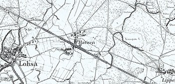
Ratzen was about a kilometer east of Lohsa. The largest town in the area was Wittichenau , because Hoyerswerda only experienced a significant increase in population later due to the large new building areas. Wittichenau was about 15 kilometers from Ratzen. The place was on the Hoyerswerda-Horka railway line , which divided the place into a northern and a southern part.
history
| year | Residents |
|---|---|
| 1777 | 8 gardeners , 14 cottagers |
| 1825 | 246 |
| 1871 | 256 |
| 1885 | 239 |
| 1905 | 209 |
| 1925 | 225 |
| 1960 | 150 |
The first documentary mention came from 1343. It was probably an older Slavic settlement, the exact age of which is unknown. There is no reliable interpretation for the place name. It probably goes back to an Old Sorbian personal name. The place was mentioned as Ratze in 1492 , followed by the name variants Ratzcha 1512, Ratze 1571, Raczen 1592 and in 1791 Razen . The current place name appears for the first time in 1800.
In 1562 a manor is documented that exercised the manorial rule in the place. In the 16th century the place was parish after Lohsa. The Austrian Lausitz came to Saxony after the Thirty Years War . Ratzen thus also belonged to the Kingdom of Saxony , but still enjoyed a certain independence. Interesting and strange at the same time in Ratzen's local history is the fact that the Protestant Saxon theologian and master of philosophy Karl David Schuchardt , pastor of the Upper Lusatian parish Spremberg from 1747 to 1781, today Neusalza-Spremberg , as "heir, feudal lord and court lord Razen, Kolpen, Geißlitz and a proportion of three women "was handed down" .
After the war of liberation against Napoleon and the Congress of Vienna , the Saxon Ratzen came to Prussia . The border with Saxony ran not far from the place. To the round hamlet Ratzen to 1895 a 1238 extended hectares large block , strip and Gutsblockflur . In 1938 the communal independence of Ratzens with its two districts Geißlitz and Kolpen ended with the incorporation to Lohsa.
As a result of the Second World War and the expellees from the former eastern territories of the German Reich, a large number of German refugees came to the Sorbian village. This had a major impact on the Sorbian population and the use of Sorbian in everyday life fell sharply. After the war ended, Ratzen became part of the Soviet occupation zone and later the GDR . The district reform in 1952 classified the community in the district of Hoyerswerda ( Cottbus district ).
The first preparatory work for opening up the Lohsa opencast mine began in 1942. To this end, the Kleine Spree north and west of Lohsa and the Lohsa-Ratzen road were laid by 1944 . It was only after the Second World War that the first excavation work began, and in 1952, the actual coal production. In 1958 the overburden conveyor bridge F 34 was installed on the opencast mine. The last 150 residents of Ratzen left the place in 1960. The two former districts of Ratzen were also devastated. Today the former residents of Ratzen meet irregularly. There is a memorial stone at the point where the place used to be . There is also a street in Lohsa that is reminiscent of Ratzen.
Population and language
For his statistics on the Sorbian population in Upper Lusatia, Arnošt Muka determined a population of 249 in the 1880s, including 245 Sorbs (98%) and only four Germans. Until the village was dissolved, it was mostly Sorbian-speaking.
See also
Web links
- Ratzen in the Digital Historical Directory of Saxony
- Ratzen meetings maintain the memory of the excavated village (lr-online.de)
Individual evidence
- ↑ Ernst Tschernik: The development of the Sorbian population . Akademie-Verlag, Berlin 1954.
Coordinates: 51 ° 23 ' N , 14 ° 26' E