
Koenigsbrück
| coat of arms | Germany map | |
|---|---|---|

|
Coordinates: 51 ° 16 ' N , 13 ° 54' E |
|
| Basic data | ||
| State : | Saxony | |
| County : | Bautzen | |
| Management Community : | Koenigsbrück | |
| Height : | 175 m above sea level NHN | |
| Area : | 78.48 km 2 | |
| Residents: | 4539 (Dec. 31, 2019) | |
| Population density : | 58 inhabitants per km 2 | |
| Postal code : | 01936 | |
| Primaries : | 035795 035240 (Röhrsdorf) |
|
| License plate : | BZ, BIW, HY, KM | |
| Community key : | 14 6 25 270 | |
| City structure: | 3 districts | |
City administration address : |
Markt 20 01936 Koenigsbrück |
|
| Website : | ||
| Mayor : | Heiko Driesnack ( CDU ) | |
| Location of the city of Königsbrück in the Bautzen district | ||
  |
||


Königsbrück ( Upper Sorbian Kinspork ) is a country town on the western edge of Upper Lusatia in Saxony ( Germany ), just under 25 km north of the state capital Dresden . It bears both the nickname “Gateway to West Lusatia ” and, more recently, “ Camellia town on the Via Regia” and is the seat of the Königsbrück administrative community .
geography
location
The Pulsnitz flows through Königsbrück . The surrounding landscape is mainly wooded heathland, in the north the Königsbrücker Heide and in the south the Laußnitzer Heide , which is part of the Westlausitz landscape protection area. The striking Keulenberg rises 6 km to the southeast .
City structure
The city is divided into three districts, the original city including the Stenz district and two other districts (population as of September 30, 2012):
- Königsbrück, 3799 inhabitants
- Graefenhain , 395 inhabitants
- Röhrsdorf , 172 inhabitants
Development of the urban area
The original city was on the right side of the Pulsnitz; the urban area was bounded in the north by the Käbnitz , in the south and west by the Pulsnitz. To the north of the city were the mountain houses on Weißbacher Lehnsflur, to the south the houses on the Meißner Lehnsflur and to the west the village of Stenz.
The manor district "Garnisionsverwaltung Königsbrück" created in 1907 was not part of the city. It comprised the old camp near Stenz, the infantry firing range near Glauschnitz , the new camp between Königsbrück and Steinborn and the newly created military training area in the north in the heath with the settled villages of Otterschütz , Quosdorf and Zietsch .
After the withdrawal of the Red Army, the city also took over the entire military area in 1992, including the devastation of Bohra , Krakow , Otterschütz, Quosdorf, Rohna , Sella , Steinborn , Zietsch and Zochau , which significantly expanded the urban area.
Neighboring communities
| Kroppen | Hermsdorf | Schwepnitz |
| Thiendorf |
.svg)
|
Neukirch |
| Laußnitz | Grossnaundorf | Haselbachtal |
history
Königsbrück was first mentioned in a document in 1248. Presumably it was created shortly before as a border fortress between the Mark Meissen and the Bohemian Upper Lusatia . The development of the city is closely linked to the Hohen Strasse / Via Regia - a medieval trade route on which Bautzen , Görlitz and Kamenz are also located. A royal duty was levied here at the national border. In 1331 Königsbrück received its town charter. Königsbrück was a strategically important border town in Upper Lusatia, which is why the cities of the Upper Lusatian Six-City Union in particular resisted any pledging of the place. As z. For example, the Lords of Schönfeld wanted to sell the city of Königsbrück to the Meissen margrave as Meissen vassals in 1350, but the Bautzeners prevented this by force and brought the city back under the Bohemian crown. 1439–1579 the city was owned by the Burgraves of Dohna , whose possessions were first referred to as lordship in 1527 . After the death of Christoph von Dohna, the town and rule of Königsbrück fell back to the Crown of Bohemia as a settled fief. Emperor Ferdinand I sold it to Caspar von Dohna on Straupitz (Niederlausitz) as early as 1562, who raised it to the fourth rank of the Upper Lusatia in the same year . In 1579 140 resident citizens were counted; including those who did not have the citizenship, the height of the inhabitants should have been about 1000 souls.

The noblemen and gentlemen of Königsbrück were:
- 1579–1726: Lords of Schellendorf - 1703–1726 Johanna Margaretha von Schellendorf b. by Friesen (1655–1728).
- 1726–1773: Barons of Friesen
- 1773–1795: Counts of Redern
- 1795–1803: Count of Münster-Meinhövel
- 1803–1856: Counts of Hohenthal
- 1856–1893: Count Wilding , Prince of Radali
- 1893–1920: Naumann family
The city coat of arms dates from 1556.
In 1819 the first Saxon savings bank was founded in Königsbrück.
In 1835, Countess Louise Charlotte von Hohenthal founded the Louisenstift, an institution for small children . The aim of the institution is and was, “To give parents who, due to their circumstances, are unable to devote their full time to bringing up their children, the opportunity to have their children brought up in an orderly manner to lay the germ of a moral and religious direction of life in the tenderest youth and to preserve it. "


On October 16, 1884, Königsbrück was connected to the railway network with the commissioning of the Klotzsche – Königsbrück railway . This line, initially designed as a narrow-gauge railway , was converted to standard gauge in 1897 and initially extended to Schwepnitz in 1899 . In 1933 and 1934, the building was finally extended to Straßgräbchen - Bernsdorf .

In 1892 the construction of a large infantry firing range began in the Laußnitzer Heide near Glauschnitz, at the same time a barrack camp ( old camp ) was built on the pane near Stenz . In the summer of 1893 these were put into operation by the 106th regiment. On September 30, 1893, the military area became an independent manor district "Schießplatz bei Königsbrück", which in 1895 received the new name "Garnisionsverwaltung Königsbrück". In October 1893 the city was elevated to a royal garrison town. The Prinz-Georg-Kaserne was built in the years 1893–1895 south of the station . In 1906, the Königsbrück military training area was built in the Königsbrück and Kraków Heath . In the following years, a new barracks location was built north of the city - the New Camp . During the First World War there was a prisoner of war camp in Königsbrück. After the end of the Second World War, the Red Army occupied the military area. Until the withdrawal on February 25, 1988, Soviet SS-12 Scaleboard nuclear missiles were stationed during the Cold War . In 1992 the withdrawal of the group of Soviet armed forces in Germany from Königsbrück was completed.
During the GDR era, the Institute for Aviation Medicine of the NVA was located in Königsbrück . Here NVA pilots and prospective pilot applicants from the age of 14, but also paratroopers, were examined for their fitness to fly. The first and only GDR cosmonaut, Sigmund Jähn , and his substitute, Eberhard Köllner , were also medically prepared for their space flight here. The Republic of Austria built a completely new building between 1984 and 1986 on the basis of bilateral agreements between the GDR and Austria, which included a vacuum decompression chamber and a high-performance centrifuge. The background for this building project was the CoCom list imposed by the USA during the Cold War , which prohibited the export of high technology from western industrial nations to communist countries. Austria, as a neutral state, bypassed this list and thus created an important building block for the GDR's defense capability at that time. After the end of the GDR, the facilities were taken over and modernized by the federal government. The internationally renowned aerophysiological training center of the Center for Aerospace Medicine of the Air Force is the current owner.
On March 24, 2010, the solar park built in the Königsbrücker Heide with 15 million euros was opened. The output is 4.4 MW.
Incorporations
- Stenz , Laußnitz-New Extension, Weißbacher Lehn, Castle District, 1939
- Graefenhain , 1994
- Röhrsdorf , 1994

Population development
| year | Residents |
|---|---|
| around 1500 | 140 |
| 1579 | approx. 1,000 |
| 1580-1800 |
low population growth due to many fires and devastation |
| 1806 | 1,050 |
| 1830 | 1,554 |
| 1832 | 1,652 |
| 1849 | 1,890 |
| 1875 | 1.926 |
| 1900 | 3,252 |
| 1925 | 3,201 |
| 1950 | 5,274 |
| 1970 | 5,248 |
| 2012 | 4,362 |
| 2013 | 4,374 |
coat of arms
Description : In blue, a continuous golden arched brick bridge with three arches and seven battlements over a brown background. A crown of golden leaves hovers over the bridge.
Religions
The inhabitants of the city are predominantly Evangelical-Lutheran or non-denominational.
politics
Since the municipal council election on May 26, 2019 , the 16 seats of the city council have been distributed among the individual groups as follows:
- AfD : 5 seats
- CDU : 4 seats
- Initiative “Lebendiges Königsbrück” (ILK): 4 seats
- Free voters Königsbrück (FWK): 3 seats
Culture and sights
The cultural monuments of the city are listed in the list of cultural monuments in Königsbrück .
- Königsbrücker Heide
- Castle with park
- Medieval market
- Via Regia model exhibition
- Main Evangelical Church
- Catholic Exaltation of the Cross
- Water tower
- Military cemetery
- Beaver adventure trail
- Reconstructed Saxon quarter milestone on Poststrasse in the course of the Via Regia on the road to Kamenz with original parts from the cemetery wall
- Original coat of arms of the Kursächsische Poststanzsäule of the small town of Krakow, which was destroyed by the Königsbrück military training area (currently in the Dresden City Museum )
- Pulsnitztal Viaduct - one of the few railway bridges with a curve. Built in 1899, closed in 2001, see list of railway bridges in Saxony
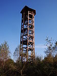
Haselberg Tower in the Königsbrücker Heide

Main Evangelical Church

Catholic Church
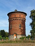
Water tower


Regular events

- Camellia show from late January to early April, depending on the bloom
- Koenigsbrücker Christmas market
- Carnival parade
- Shooting festival
- Sunset pool
- Pottery market (always in odd years on the 3rd weekend in September)
Memorials


- Mausoleum of the Naumann family behind the main church in Königsbrück
- At the entrance to the cemetery on Gartenstrasse, a grave and a memorial stone commemorate two unknown, presumably Polish, concentration camp prisoners who were murdered by SS men on a death march in the spring of 1945 .
- Memorial on the Scheibischer Berg
- Military cemetery for the prisoners of war who died in Koenigsbrück
- War memorial in Schlossstrasse for those who died in the campaigns of 1866 and 1870/71
- War memorial for the fallen soldiers of the First World War
- Memorial site for the villages in Röhrsdorf that were devastated by the Königsbrück military training area
Leisure and sports facilities
- Stadtbad
- Sports field (artificial turf)
- Gym
- Four-lane bowling facility
- Sports facility with bowling alley for recreational sports in the Graefenhain district
- Tennis court in Graefenhain
education
- Arthur Kießling School ( Oberschule ), formerly Wilhelm Pieck Oberschule
- Juri Gagarin School (Primary School)
- Königsbrücker training center gGmbH
- Children's house rainbow
- Children's house Rappelkiste
traffic
The station Königsbrück is located on the railway line Dresden-Klotzsche-Straßgräbchen-Bernsdorf and since 2001 the northern end of the section that are still in operation. The regional trains of the Central German Regiobahn run every hour via Ottendorf-Okrilla to Dresden-Neustadt station . for which they need about 45 minutes. One railcar bears the name "City of Königsbrück". You can take the bus to Hoyerswerda, Kamenz, Pulsnitz and Röhrsdorf.
The Bundesstrasse 97 leads through Königsbrück to Dresden or Schenkendöbern and the B 98 towards Zeithain.
The federal highway 4 can be reached in about 15 km away in Hermsdorf and the federal highway 13 in about 13 km away in Thiendorf .
Personalities
sons and daughters of the town
- Georg Bartisch (1535–1607), ophthalmologist and urologist, born in Graefenhain
- Karl Gottlob Sperbach (1694–1772), philologist
- Karl August Großmann (1741– ~ 1798), engraver and publisher
- Johann Karl August Gregor Müglich (1793–1862), Protestant and Catholic theologian and author
- Widar Ziehnert (1814–1839), poet and collector of sagas
- Julius Rose (1828–1911), painter, pseudonyms Georg Carré, Georg Carée and A (ntonio) (Julius) Rose
- Karl Edwin Leuthold (1847–1891), lawyer and mining lawyer, director of the Saxon Mining Office and professor at the Freiberg Mining Academy
- Curt Tausch (1899–1969), sculptor
- Wolfgang Hänsch (1929–2013), architect
Personalities who work or have worked on site
- Donat Pfeiffer (around 1500–1562), first Protestant preacher in Königsbrück
- Justus von Gebhard (1588–1656), lawyer and Imperial Privy Councilor in Vienna
- Gottfried Blobel (1758–1809), pastor
- Johann Friedrich Voigtländer (1769–1844), Protestant theologian
- Karl Gustav Schmalz (1775–1849), poor doctor and founder of the widows' fund in Königsbrück from 1807–1836
- Amadeus Johann Gottlieb Ziehnert (1785–1856), Protestant theologian and author
- Leberecht Immanuel Döring (1786–1833), philologist and Protestant theologian
- Ernst Ferdinand Rückert (1795–1843), doctor and author
- Edmond Delphaut (1891–1957), French sculptor and painter
- Ernst Rudolf Worlitzsch (1895–1980), mathematician and physicist
- Rudolf Sitte (1922–2009), sculptor, painter, graphic artist and art ceramist
- Clas Michael Naumann zu Königsbrück (1939–2004), zoologist, grew up in Königsbrück until 1945
- as well as the rulers and their wives (see rulership of Königsbrück )
literature
- [Ernst Theodor Edmund] Wauer, The Parish of Königsbrück. In: New Saxon Church Gallery: Dioceses of Bautzen and Kamenz , Arwed Strauch, Leipzig approx. 1905, [Part II: The Diocese of Kamenz], Sp. 351–426
- Cornelius Gurlitt : Königsbrück. In: Descriptive representation of the older architectural and art monuments of the Kingdom of Saxony. 35. Issue: Amtshauptmannschaft Kamenz (Land) . CC Meinhold, Dresden 1912, p. 90.
Web links
- City website
- Königsbrück in the Digital Historical Directory of Saxony
- Training in Königsbrück
Individual evidence
- ↑ Population of the Free State of Saxony by municipalities on December 31, 2019 ( help on this ).
- ^ City of Königsbrück: data and facts. Retrieved October 9, 2011 .
- ↑ Königsbrück solar park officially opened. (No longer available online.) SMWA Saxon State Ministry for Economics, Labor and Transport, March 26, 2010, formerly in the original ; Retrieved April 7, 2010 . ( Page no longer available , search in web archives ) Info: The link was automatically marked as defective. Please check the link according to the instructions and then remove this notice.
- ↑ Results of the 2019 municipal council elections

Cities:
Bautzen (Budyšin) |
Bernsdorf (Upper Lusatia) |
Bischofswerda |
Elstra (Halštrow) |
Großröhrsdorf |
Hoyerswerda (Wojerecy) |
Kamenz (Kamjenc) |
Koenigsbrück |
Lauta |
Pulsnitz |
Radeberg |
Schirgiswalde-Kirschau |
Weißenberg (Wóspork) |
Wilthen |
Wittichenau (Kulow)
Municipalities:
Arnsdorf |
Burkau (Porchow) |
Crostwitz (Chrósćicy) |
Cunewalde |
Demitz-Thumitz |
Doberschau Gaussig (Dobruša Huska) |
Elsterheide (Halštrowska hola) |
Frankenthal |
Göda (Hodźij) |
Großdubrau (Wulka Dubrawa) |
Großharthau |
Großnaundorf |
Großpostwitz / OL (Budestecy) |
Haselbachtal |
Hochkirch (Bukecy) |
Königswartha (Rakecy) |
Kubschütz (Kubšicy) |
Laußnitz |
Lichtenberg |
Lohsa (Łaz) |
Malschwitz (Malešecy) |
Nebelschütz (Njebjelčicy) |
Neschwitz (Njeswačidło) |
Neukirch |
Neukirch / Lausitz |
Obergurig (Hornja Hórka) |
Ohorn |
Oßling (Wóslink) |
Ottendorf-Okrilla |
Panschwitz-Kuckau (Pančicy-Kukow) |
Puschwitz (Bóšicy) |
Räckelwitz (Worklecy) |
Radibor (Radwor) |
Ralbitz-Rosenthal (Ralbicy-Róžant) |
Rammenau |
Schmölln-Putzkau |
Schwepnitz |
Sohland on the Spree |
Spreetal (Sprjewiny Doł) |
Steina |
Steinigtwolmsdorf |
Wachau (Saxony)