
Krakow (Saxony)
Krakow ( Upper Sorbian Krakow ) was a market in the Amtshauptmannschaft Kamenz (today the district of Bautzen ) in Saxony . In 1938 the place was cleared due to the expansion of the Königsbrück military training area and destroyed after the Second World War.
geography
location
Krakow was located seven kilometers northwest of Koenigsbrück an der Pulsnitz in the Krakauische Heide. The alleys group like advanced street village with block and strip corridor stretched on either side of the river; to the west was the (larger) Meissen side, to the east the Upper Lusatian side. Kraków was surrounded by several peaks: to the southeast the Kiefernberge ( 166 m ), southwest of the Laaken ( 83 m ), to the west of the Weinberg ( 184 m ), the Eichberg ( 186 m ) and the Krakauer Berg ( 172 m ), to the northwest of the Bornberg ( 176 m ).
Neighboring places
| Liège / Cultivation | ( Zochau ) †, ( Rohna ) † | Zeisholz , ( Otterschütz ) † |
| ( Sella ) † |
.svg)
|
( Zietsch ) †, ( Quosdorf ) † |
| Röhrsdorf | ( Bohra ) † | ( Steinborn ) † |
history
The first mention of Cracow as the seat of the Rudegerus de Cracowe comes from the year 1248. Other forms of the name were Krakow (1420), Krokow (1479), Crokaw (1495), Krockaw (1527) and Krackaw (1658). The place was called Krakow since 1875 .
The original street village with a manor was built between Königsbrück and Ortrand at a ford through the Pulsnitz, which represented the border between Upper Lusatia and the Margraviate of Meißen , and was mainly located on the Meißner side. However, there was also a smaller settlement on the Upper Lusatian side, which was formerly called Cracow in the Kingdom or the Kingdom (after the Kingdom of Bohemia).
In 1510 the place was referred to as a market town and since 1547 as a town. On August 16, 1651, Elector Johann Georg I allowed the establishment of a local craft guild. In 1732 the elector had a distance column erected in Krakow, the damaged original coat of arms of which was preserved in the Dresden City Museum .
In 1637 the rectory burned down during the Thirty Years War . In 1742 the kingdom burned down almost completely. In 1746 the manor house burned down on the Upper Lusatian side, with the fire spreading to the Meißner side and destroying numerous buildings, the rectory with its library and church records, and killing several people. In the 19th century Krakow became a market town again.

Church (1915)

Church (1915)
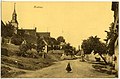
Dorfstrasse (1915)

Inn (1915)


_03.jpg)
_05.jpg)
The parish church, which had existed since 1539, also included the neighboring towns of Bohra , Zochau , Röhrsdorf and Sella , and after 1635 the Oberlausitz villages of Steinborn, Zietsch, Otterschütz and Quosdorf. In 1936 the Kraków Church became a branch church of the Königsbrück parish. The altar dates from 1441 and was consecrated by Bishop Augustin von Meißen. The church received its tower only in 1798.
There is evidence of a Vorwerk since 1445. Since 1551 there was a manor in Cracow to which the residents of both sides were subordinate. The Krakow manor had the following owners:
- 16th century: Karl and Christoph von Kitscher
- 1614: Hans von Herrnhausen
- 1648: Electress Magdalena Sibylla of Saxony
- 1661: Johann Georg von Rechenberg
- 1663: Wilhelm von Pistoris
- 1702: Valentin Schäffer and his descendants
Administratively, Krakow belonged to the Hayn and Bautzen district until the middle of the 19th century . In 1843 both shares were assigned to the Kamenz office. With the reorganization of the Saxon administrative structures, Krakow was assigned to the Königsbrück court office in 1856 and to the Kamenz administration in 1875 . In 1907 the Königsbrück military training area was laid out east of the market in the Kraków Heath . In 1938 the Krakow market was closed as part of the expansion of the Königsbrück military training area . The properties were bought by the German Reich and the 478 residents were relocated. The place was evacuated on April 1, 1938. Some residents moved to the villages of Tauscha , Sacka and Dallwitz . The 421 hectare parish corridor became part of the military training area.
After the end of the Second World War, the place was briefly repopulated by refugees. However, the Soviet troops arranged for an immediate evacuation in order to continue using the training area. Krakow was later destroyed.
In the 1990s, a small half-timbered building with the Krakow bells was built in Röhrsdorf. An attached plaque commemorates eight villages in the Kraków church play, which had to give way to the military training area in 1907 and 1938.
Population development
| year | Residents |
|---|---|
| 1551 | 26 possessed men , 37 residents |
| 1764 | 14 possessed men, 23 cottagers |
| 1834 | 380 |
| 1871 | 429 |
| 1890 | 430 |
| 1910 | 406 |
| 1925 | 404 |
| 1938 | 478 |
literature
- Krakow . In: August Schumann : Complete State, Post and Newspaper Lexicon of Saxony. 5th volume. Schumann, Zwickau 1818, pp. 119–123.
- Cornelius Gurlitt : Krakow. In: Descriptive representation of the older architectural and art monuments of the Kingdom of Saxony. 35. Issue: Amtshauptmannschaft Kamenz (Land) . CC Meinhold, Dresden 1912, p. 121.
Web links
- Krakow in the Digital Historical Directory of Saxony
- Location views from 1937
Individual evidence
- ↑ The natural area of the Königsbrück military training area. In: About Königsbrück. From Koenigsbrueck.de, accessed on October 29, 2019.
- ↑ Tüp from 1919 - The military history of the Königsbrück military training area since 1919. In: About Königsbrück. From Koenigsbrueck.de, accessed on October 29, 2019.
- ↑ Röhrsdorf. In: Großenhainer Pflege (= values of the German homeland . Volume 70). 1st edition. Böhlau, Cologne / Weimar / Vienna 2008, ISBN 978-3-412-09706-6 , p. 195., Kirchenspiel Krakau in the text.
- ↑ Krakow in the Digital Historical Directory of Saxony
- ↑ on the Meissen page
Coordinates: 51 ° 19 ' N , 13 ° 51' E