
Keulenberg
| Keulenberg | ||
|---|---|---|
 The Keulenberg as seen from Wachau (Saxony) . |
||
| height | 413.4 m | |
| location | Saxony ( Germany ) | |
| Mountains | Lusatian highlands | |
| Coordinates | 51 ° 13 '38 " N , 13 ° 57' 21" E | |
|
||
| rock | granite | |
| Age of the rock | Cambrian | |
| particularities | Augustobelisk observation tower Bismarck monument television tower |
|

The Keulenberg is a prominent elevation in the Lusatian mountains and is therefore called the Guardian of West Lusatia . It consists of two peaks separated by a wide saddle - the large one with 413.4 m and the small Keulenberg with 390.1 m.
Location and surroundings
The Keulenberg massif forms the westernmost foothills of the West Lusatian hills and mountains . It consists of the Großer and Kleiner Keulenberg, the Hubrigberg (267.4 m), the Vogelberg (296.4 m) and the Karschberg (275.3 m). The Keulenberg represents the last major elevation up to the Baltic Sea in a northerly direction . It is located 6 km southeast of the city of Königsbrück and 6 km northwest of the city center of Pulsnitz between the towns of Oberlichtenau , Reichenbach , Reichenau , Graefenhain , Höckendorf and Großnaundorf . The summit is located in the area of the city of Pulsnitz in the Oberlichtenau district. The Pulsnitz flows past to the east and north .
history
Germanic tribes used the Keulenberg as a sacrificial site . The first mentions can be found in a border document from 1213 as "montis Radebize" and in the Upper Lusatian border document from 1241 as "mons radewicz", in German Radewitzberg. For many centuries, the mountain was considered to be the boundary between the Bohemian Upper Lusatia and the Meissen-Saxon heartland . Until the 13th century, the corridor probably belonged to the Pulsnitz rule, after which the Junkers von Schönberg are listed as owners. In the Meißner diocese register of 1346 is the name "Kulenberg" and the parish priest Johannes Lohde (1618–1699) of Langhennersdorf , who was born in Königsbrück, wrote in 1647 about "Kailberg". Pastor Ehrenhaus from Pulsnitz used in his book Three great country preachers in 1662 , the Keulenberg, the Eierberg and the Gückelsberg, who preach about repentance, faith and the new obedience , meaning the Eierberg near Lichtenberg and the Gickelsberg near Pulsnitz, for the first time in writing Name "Keulenberg". It was to remain with this popular name to this day.
Around 1720 the manor owner Christian Gottlieb von Holtzendorff purchased the site. In 1733 his wife Friedericke Sophie von Holtzendorff, mistress of Oberlichtenau, had a mountain hut built. The building, also known as the Jagdschlösschen, was hexagonal, made of granite and bricks, two stories and without a roof about 20 feet high. Every year on July 2nd ( Visitation of the Virgin Mary ) there were folk and rifle festivals, for which the gentlemen donated a silver cup. On December 18, 1833, a heavy storm with hurricane gusts tore down the roof and the upper floor. The ruin can still be seen today on the north-western cliff.
During the Seven Years' War , Frederick II of Prussia (1712–1786) held a council of war here in 1760. A servant from Reichenau had to serve as a guide for him and his entourage. At first he thought the Prussian king was an officer. When he recognized his mistake and stepped back, frightened, old Fritz said to him: “He stay here. He can hear everything. He's not going to make war against me. ”During his studies, Theodor Körner (1791–1813) stayed on the mountain in 1809 . On the occasion of the 50th anniversary of the throne of King Friedrich August I of Saxony (1750-1827) in 1818, on September 18, 1818, a jubilee was held on the "Keilberg" and the August obelisk was erected. The initiated renaming in Augustusberg could not prevail in the long term. A Keulenberg club already existed at that time. A Bismarck monument was added on September 10, 1899 . In 1948 SED comrades overthrew the monuments. Otto von Bismarck and the Wettiner returned to their bases in 1992 and 1994, respectively.
In 1862 Ferdinand Bürger had a one-story mountain inn built, which burned down in 1866. This year a 7 m deep well was sunk into the rock. In 1868 Ferdinand Bürger built the second clubhouse, which was extended in 1889 and provided with a small hall. Another expansion followed in 1907. In 1945 the closed mountain restaurant was looted. On April 24, 1962, the last serving took place in the guest rooms, Werner Krolikowski (* 1928), first secretary of the SED district leadership, confiscated the building and turned it into a festival and hunting domicile. In 1966 the party stopped this use and the building began to deteriorate. On February 1, 1990, the community was awarded the property of the former hut, and on March 25, 1990, it was demolished. From November 28, 1990, the former farm building served as a temporary solution. From June 2010 to the end of 2011, the mountain restaurant was again available to summit visitors, and since the beginning of the 2012 season there has been an outdoor snack bar at least on Saturdays, Sundays and public holidays. Since June 2010 the boarding house on the summit has also opened its doors again.
Keulenberg Station 10 of the first-order network was part of the Royal Saxon triangulation . Site manager Helmert erected the corresponding surveying column for 818 marks on the highest point of the summit in August 1864. Smaller cuboids made of Kamenz granite are stacked like a brick wall in 13 layers and are connected by metal clips. The 0.1 m deep, 5.0 m high pillar is square, tapers towards the top and is 49 cm wide at the top. The original inscription, deepened in a rectangular parallelepiped, is easy to read and reads: Station / "Keulenberg" / the Central European / Degree Measurement. / K. Saxony / 1864 .
A wooden surveying scaffold erected in 1890 also served as an observation tower, was destroyed in a storm in 1901 and replaced by a new building in the same year. In 1920 the wooden structure had to be closed due to dilapidation and finally removed in 1925. The iron successor was inaugurated on May 10, 1925. In 1987, the Graefenhain blacksmith Großmann renewed the decking and stairs on behalf of the customs administration . The observation tower encloses the surveying column. In 1936 a 64 m high first-order surveying tower was built from around 130 solid cubic meters of wood. The wooden successor building from 1954 was 54 m high and was blown up in 1968 because it was dilapidated.
The Air Force was 1939, the "radio monitoring station East" build on the Keulenberg, the final work led POWs from. In 1945 the radio towers were demolished. The radio buildings were retained and were used as a SED district party school from 1948, as the first district children's recreation home from 1949 and as a social home for the mentally and physically handicapped from 1950. In 1953, the Sachsenwerk Radeberg built a double tower for the first television attempts. In 1961 the Ministry of the Interior had the social home cleared, the People's Police took over the building for training purposes and left it in 1985 because of its desolate condition. From 1986 to March 31, 1990, the customs administration held training courses here. In 1991 a new television tower was built on behalf of Deutsche Telekom .
In 1955, at the Keulenberg Festival, Herbert Kirfe's “Keulenber Link” was heard for the first time. From 1962 GDR citizens were forbidden to enter the Keulenberg summit, only the “ armed organs ” were allowed access. To enforce the regulation, a fence was erected, which was raised in 1986. Displeasure about the lockdown grew over the decades. On November 12, 1989, access was regained under the mottos “A free people for a free mountain” and “Keulenberg belongs to the people”. In 1991 the tradition of mountain and rifle festivals was revived. In 2014 the Keulenbergverein dissolved due to a lack of young talent.
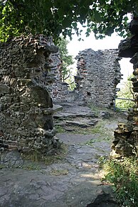
Ruin of the Bergschlösschen
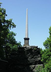
August obelisk
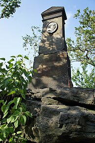
Bismarck Monument

Observation tower

Television tower


Say
Numerous legends of miners , giants , mermaids , goblins and other figures entwine around the elevation . They are said to have lived in the woods and cliffs. The legend “The giant stones in Nassau” tells of a giant family on the Keulenberg who lived with another giant family on the Oschatzer Kulmberg in Handel and threw giant fir trees and stone walls at each other. One youth in the family towered over the others in size and beauty and loved the graceful daughter of the prince of the Elbgau. But Bila did not return this affection. When the giant sons asked their father for their hand, the latter replied evasively that they might try to earn it first. Meanwhile, another won the Virgin's heart, a poor shepherd who looked after the prince's sheep on the sunny slopes of the Golk Mountains. The princess was sleeping by the gushing Gaserbach when the youth killed a poisonous snake that she was about to bite. Bila, who was dreaming of the same youth, woke up from her slumber, saw in him her savior and, full of gratitude, promised him heart and hand. The giants did not keep their young happiness hidden for long. One day they noticed a rendezvous between Bila and the shepherd on the Nassau stream and both hurled huge blocks of stone at him from their mountain. But he remained unharmed because he was pious and good and was therefore under the protection of the gods. When the prince found out about the incident, he accepted the shepherd as an oath and built a sacrificial place on one of these stones in thanks for the divine assistance. The stone can still be seen today below Zadel on Golkers Revier, is officially called Gose and popularly Riesenstein. A second giant stone on the banks of the Nassau bears witness to the fierce struggle between the two giants that broke out when they realized that the beautiful Bila was lost to them, with the winner only surviving the loser for a short time.
geology

The Keulenberg massif originated in the Cambrian and consists mainly of two-mica granodiorite (an anatexite ). The up to 15 m high freestanding summit cliffs show a distinctive wool sack weathering . The northern inland glaciation fundamentally reshaped the elevations and created e.g. B. the steep northwest slope of the Großer Keulenberg. During the two Elster glaciers (Elster 1 and Elster 2 stages), only the highest peaks looked out of the glacier as nunataks . The intense frost weathering that began at this time continued in the Saale and Vistula glacial periods , when the area was in the periglacial area . The result is the extensive mass of rubble . In the north-western and western flanks, biotite - granodiorite replaces the rock. In the first place, " Lusatian granite " was extracted in quarries . The overburden in the massif once consisted of greywacke . This was altered in the lower area during the recrystallization in granodiorite and eroded in the upper area . The geology of the Keulenberg and its surroundings was described as early as 1769 by Christian Friedrich Schulze , in 1780 by Johann Friedrich Wilhelm von Charpentier and in 1785 by Nathanael Gottfried Leske . Reports of gold finds already referred the former to the realm of myth.
Flora and fauna
With the exception of the partially forested Karschberg, all the heights of the Keulenberg massif are densely forested and form a closed forest area. This growth has only been detectable since the 17th century. Previously, arable land stretched to just below the summit, as is noted on old maps by Matthias Oeder († 1614) “Feldt drofen”. A testimony to this use are the many stone walls that served as corridor, field and pen boundaries. The Keulenberg summit has been under protection as an area natural monument since 1938 . The local occurrences of real arnica (Arnica montana) and long-leaved sundew (Drosera anglica) are considered extinct.
tourism
The elevation has been a popular excursion destination for centuries and has been climbed by many important personalities. There are some copper engravings by Adrian Ludwig Richter (1803–1884) with motifs from the Großer Keulenberg. Several marked hiking trails and the educational trail that begins at the Oberlichtenau Castle Park lead up to it. The summit and the observation tower reward the effort with a wide panoramic view of the adjacent mountains, the Laußnitzer Heide , the Upper Lusatian heath and pond area and as far as Brandenburg . Other sights include the ruins of a hunting lodge, a historic surveying column , the August obelisk and a Bismarck monument . The snack bar has been closed since August 2015 and the former restaurant including the sanitary building is now owned by a new owner.

literature
- Olaf Bastian: The Keulenberg in West Lusatia. in: Landesverein Sächsischer Heimatschutz (Hg.): Calendar Sächsische Heimat 2018, calendar sheet 34th week
- Andreas Gerth: A 9 (Z) - Keulenberg near Oberlichtenau. In: Journey into the geological history of Upper Lusatia, the Elbe Sandstone Mountains and Northern Bohemia. Part 1 (Proterozoiukum to chalk). Oberlausitzer Verlag Frank Nürnberger, Spitzkunnersdorf 2013, ISBN 978-3-941908-22-2 , pp. 102-106.
- Interest group Nagelsche Säulen, Staatsbetrieb Geobasisinformationen und Vermessung Sachsen (Ed.): Station Keulenberg. In: Historical surveying columns in Saxony. Schütze Engler Weber Verlag GbR, Dresden 2012, ISBN 978-3-936203-18-9 , p. 56.
- Christian Friedrich Schulze : News of the minerals and fossils present in the Dreßdnischen area. In: New Hamburg magazine or continuation of collected writings, from natural research, general urban and rural economics and the pleasant sciences in general. 31st piece. Adam Heinrich Hollens widow, Leipzig 1769, pp. 195–232. Digital edition in: kreidefossilien.de - portal to Saxon chalk , PDF; 1,755 kB .
- Friedrich Bernhard Störzner : The club or Augustusberg. In: What the Heimat tells. Legends, historical images and memorable events from Saxony. Arwed Strauch, Leipzig 1904, pp. 261-276. Digital edition in: Wikisource , online .
Web links
Individual evidence
- ^ A b André Micklitza, Kerstin Micklitza: Lausitz travel guide. From the Spreewald to the Zittau Mountains. 1st edition. Domowina-Verlag , Bautzen 1996, ISBN 3-7420-1671-7 , p. 116.
- ↑ a b c d e f g h i j k l Landesvermessungsamt Sachsen (ed.): The Keulenberg. In: Topographic Map 1: 25,000. Edition with hiking trails. Sheet 41 - Kamenz, Pulsnitz. 1st edition. Dresden 1997, ISBN 3-89679-062-5 .
- ↑ a b c d Andreas Gerth: A 9 (Z) - Keulenberg near Oberlichtenau. In: Journey into the geological history of Upper Lusatia, the Elbe Sandstone Mountains and Northern Bohemia. Part 1 (Proterozoiukum to chalk). Oberlausitzer Verlag Frank Nürnberger, Spitzkunnersdorf 2013, ISBN 978-3-941908-22-2 , pp. 102-106.
- ↑ The Keulenberg - location and surroundings. In: www.keulenberg.info. Förster's Community Service, accessed March 15, 2014 .
- ↑ Eberhard Franz: The list of names from the parish Langhennersdorf. In: A list of the names of clergymen who have worked and lived in the Freiberg ephorie since the Reformation in 1539 as superintendents of the church district, as clergy at Freiberg Cathedral and as pastors, deacons, vicars and church school teachers in the individual parishes of the Freiberg church district . P. 28. Digital edition in: Ancestry research by Dietmar Seipt , online .
- ↑ Friedrich Bernhard Störzner : The club or Augustusberg. In: What the Heimat tells. Legends, historical images and memorable events from Saxony. Arwed Strauch, Leipzig 1904, pp. 261-276. Digital edition in: Wikisource , online .
- ↑ Ruin information board on Keulenberg
- ↑ a b The Keulenberg - History. In: www.keulenberg.info. Förster's Community Service, accessed March 15, 2014 .
- ^ Sächsische Zeitung (Kamenz edition): This is how it is with our mining communities. Sächsische Zeitung, December 17, 2011, accessed on July 15, 2012 .
- ↑ www.keulenberg-sachsen.de: "News: Dates and Events". Keulenberg Gastronomie UG, accessed on July 15, 2012 .
- ↑ a b Interest group Nagelsche Säulen, state enterprise geographic base information and surveying Saxony (publisher): Station Keulenberg. In: Historical surveying columns in Saxony. Schütze Engler Weber Verlag GbR, Dresden 2012, ISBN 978-3-936203-18-9 , p. 56.
- ↑ Frank Sühnel: The Keulenberg Association has disbanded - why? (Saxon newspaper - Kamenz). In: www.keulenberg.info. Försters Gemeinde Service, January 23, 2014, accessed on March 25, 2014 (article in the Sächsische Zeitung, Kamenz edition).
- ^ Frank Nürnberger: The giant stones in Nassau. In: Large Upper Lusatian saga book. Oberlausitzer Verlag Frank Nürnberger, Spitzkunnersdorf 1998, ISBN 3-933827-01-9 , pp. 214-215.
- ↑ Andreas Gerth: 13th breakdown table. In: Journey into the geological history of Upper Lusatia, the Elbe Sandstone Mountains and Northern Bohemia. Part 1 (Proterozoiukum to chalk). Oberlausitzer Verlag Frank Nürnberger, Spitzkunnersdorf 2013, ISBN 978-3-941908-22-2 , pp. 525-528.
- ↑ Wolfgang Böhnert, Wolfgang Buder, Steffi Hempel, Anja Herrmann, Ulrike Junker, Katrin Landgraf, Aline Langhof, Frank Richter, Sabine Walter: Protected property Arnika (Arnica montana). In: Alternative funding approaches for natural biological diversity. (= LfULG series of publications. Issue 25/2012). Saxon State Office for Environment, Agriculture and Geology, Dresden 2010, ISSN 1867-2868 , p. 60. Digital edition in: Saxon State Office for Environment, Agriculture and Geology , PDF; 1,513 kB
- ↑ Wolfgang Buder, Hans-Jurgen Hardtke, Sabine Hering, Aline Langhof, Frank Müller, Dietmar Schulz: Drosera longifolia L. (Drosera anglica Huds.) Long-leaved sundew. In: Fern and seed plants. Stock situation and protection of selected species in Saxony . Saxon State Office for Environment, Agriculture and Geology, Dresden 2010, p. 74. Digital edition in: Saxon State Office for Environment, Agriculture and Geology , PDF; 6,460 kB ( Memento of the original from March 4, 2016 in the Internet Archive ) Info: The archive link was inserted automatically and has not yet been checked. Please check the original and archive link according to the instructions and then remove this notice.
- ↑ L.Förster: Keulenberg - highest elevation between Dresden and Sweden. In: p27707.typo3server.info. Retrieved September 2, 2016 .