
Laußnitz Heath


The Laußnitzer Heide is an approximately 50 km² forest area northeast of Dresden . It belongs to the Königsbrück-Ruhlander Heiden natural area .
location
The Laußnitzer Heide borders in the south on Ottendorf-Okrilla and its district Medingen , in the west on Großdittmannsdorf , Würschnitz , Tauscha and Sacka , in the north on Röhrsdorf , Glauschnitz and the Königsbrücker Heide , in the northeast on Laußnitz as the namesake and former chamber property of the Electoral Saxon rulers ; and in the east at Höckendorf and Lomnitz .
description
The Laußnitzer Heide is mostly overgrown with pines , spruces and larches (approx. 89%) and a small proportion of deciduous trees, especially beech , oak and birch . In addition to the heathland, there are also moors . The eastern area of the Laußnitzer Heide is predominantly flat marshland , the western area is hilly.
The height profile rises from around 160 m near Medingen to around 200 m in the north-eastern part near Laußnitz. The most striking elevations are the Vordere Buchberg with 245 m, the Rear Buchberg with the fire watch tower with 254 m, the Mittelberg with 246.9 m and the Walberberg with 233.9 m right next to Laußnitz. These elevations are all to the west of federal highway 97 . They are all wooded and do not offer a view of the heath area - the fire watch tower is not open to the public. In the southwest is the nature reserve (NSG) of the forest moors near Großdittmannsdorf and the NSG moor forest on the Pech river near Medingen . Part of the Laußnitzer Heide is also designated as an EU bird sanctuary (SPA) under Natura 2000 .


Until the beginning of drainage in 1818, the black pond in the south with an area of around 0.3 km² was the largest stagnant body of water in the Laußnitzer Heide. The dam on the former south bank can still be seen from here. The pond extended from there about 1 km to the north. Today the Dammweg leads over the dam, which branches off from Höckendorfer Straße at the Laußnitz Süd industrial park to the southeast. Since the area was finally drained around 1850, wing C now leads through the middle of the former pond. In the far north of the Laußnitzer Heide north of Glauschnitz on the border with the Königsbrücker Heide there is a small and a large black pond, both of which have since been renatured.
The forest area of the Laußnitzer Heide is joined by neighboring forest areas such as the Radeburger Heide in the west, the Königsbrücker Heide in the north, the Keulenberg area near Graefenhain and Höckendorf and the Mittelheide near Lomnitz without delimitation.
history
Within today's area of the Laußnitzer Heide there were three villages that fell victim to the Hussite Wars in 1431 : Nicklasdorf, Johnsdorf and Gumprechtsdorf. All three villages remained deserted . Remains of the church ruins in Nicklasdorf are said to have been torn down in 1836 by the royal district forester Friedrich August Kasten, who lived in Laußnitz. The stones of the Nickelskirche on the old rafter path (at aisle 14 between wings F and G north of the curve of the B 97) were supposedly used to improve the forest paths.
The very old forest area has long belonged to the Laußnitz Chamber Estate and was described as a mixed forest area in 1591. In the Middle Ages it was owned by the Wettins who used it for hunting , while the region was also used for agriculture.
Agriculture suffered a severe slump in the Thirty Years War , which led to an increase in the number of game animals and thus in turn an increase in hunting. In the 18th and 19th centuries, the high level of browsing and intensive, unregulated use of wood that goes hand in hand with the high number of wild animals resulted in the deciduous forest in particular being greatly reduced. It was not until 1811 that the reforestation of the site began, mainly with the help of Heinrich von Cotta , mainly with pine and spruce.
During the GDR era, the forest area suffered considerable damage through the use of the Soviet armed forces and higher levels of industrial emissions in the 1980s. These were quickly removed after 1990 and are now mostly overgrown by nature.
Today, about half of the Laußnitzer Heide belongs to the West Lusatia landscape protection area . In the seed kiln built in Laußnitz in 1822 there is a museum that also deals with the history of the Laußnitzer Heide.
Wolves in the Laußnitzer Heide
The wolf monument in Laußnitzer Heide was erected to commemorate the last wolf hunt in 1740, when the last wolf was shot. Since 2019 the Laußnitzer Heide has been the settlement area of a pack of wolves again .
Milestones and survey points
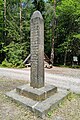
On today's B 98 in the direction of Grossenhain , just before the old forest border, there is the remainder of a Saxon postal milestone . The all-mile column bears the year 1722, the monogram AR for Augustus Rex and the inscription Hain for Grossenhain in one direction and Königsbrück in the opposite direction. A royal Saxon half-milestone from 1836, which is also in a poor state of preservation, is located near the wolf monument on the B 97. At the rear Buchberg there is a station of the Royal Saxon triangulation . The first order station from 1865 with the number 29 was used for Central European degree measurement .

Remnants of a full mile column from 1722 on the B 98

Royal Saxon half-milestone from 1836 on the B 97

Station number 29 of the Central European degree measurement from 1865


Path network and path pillars

The first map of the Laußnitz Heath made in 1555 by the Leipzig mathematics professor Johannes Hommel (Humelius). There is already a central point on this map where the Green Pillar is today. The first precise surveying work was carried out in 1595 by the surveyor and cartographer Matthias Öder . They primarily served the hunting needs of the Wettin princes ruling at this time. The Ödersche map also shows a cobweb-shaped network of paths. At that time there were eight large radial wings, labeled 1 through 8 clockwise. Of these, the Green One (towards the south), the Old Three (towards the west) and the Old Seven (towards the east) are still there today. There are also remnants of some of the almost concentrically arranged cross paths around the center, which have also been numbered from the inside. Of these old cross paths, there are still the old five and the old six, especially branching off south of the green column from the green one towards the east, which should not be confused with the old radial wings.
Today's network of paths with parallel wings and aisles crossing at right angles to Heinrich von Cotta and his son Friedrich Wilhelm von Cotta was laid out between 1826 and 1832 for primarily forestry use. The strictly straight wings A to M were given a distance of 200 Saxon field measuring rods (around 859 m) and a width of 2 rods (8.6 m). The old wings 2 and 6 now became wing E through the central point. Wing A is in the southeast near Lomnitz and wing M is in the northwest, north of Tauscha. Perpendicular to this, aisles with a width of half a rod (2.1 m) were laid at a distance of 100 rods (around 429.5 m). The aisles were given numbers from 1 to 21. Aisle 1 is located in the southwest of the Laußnitzer Heide near Großdittmannsdorf and the aisle 21 in the northeast near Glauschnitz. The old wings 4 and 8 now became aisle 13. At the end, the green column was erected at the former central point E13 in 1832. Aisle 21 is the shortest aisle due to the outer border of the Laußnitzer Heide. It is the only one that has no crossing points with wings and is therefore omitted in many records.
For better orientation, pillars were set up at all intersections between wings and aisles. In addition, wing paths were marked with pillars on the edge of the heather and at intersections with major roads (such as today's B 97 and B 98 ). A very large column stands at the confluence of wing D with today's B 97 north of Ottendorf-Okrilla. Even intersections with old radial wing paths are sometimes marked, for example the confluence of the old seven in wing D. Of the path stones, next to the green column, there is currently only one stone to mark the intersection of wing D with the Schlagweg under monument protection (number 09287180 on the Saxon list of monuments).
Aisle 6 is now paved throughout and leads in the Bautzen district as K 9261 from Ottendorf-Okrilla in the direction of Würschnitz. The wings that branch off from it are now access roads to the south-east to the gravel pit and the Maxam's explosives store .
Green column from 1832 at the junction of wing E with aisle 13

Column from 1836 at the confluence of wing D with today's B 97
Crossing wing A with aisle 10

Crossing wing B with aisle 13

Crossing wing D with aisle 16
The confluence of the Old Seven in wing D near D15


Forest border and its marking
.jpg)

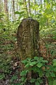
The edge of the Laußnitzer Heide used to be marked by so-called laughing crosses on trees, piles of stones or large stones. After many years of deliberation, initiated by August the Strong , in 1733 the Bailiff von Radeberg submitted a cost estimate for the acquisition, labeling and setting of 400 sandstones to mark the electoral forest boundaries around the Laußnitzer Heide and the forest at Radeberg. The Laußnitzer Heide belonged to the Radeberg (AR) office at the time, the Grossenhain office (AGrH) began on the west and north side, to which Glauschnitz also belonged, and the Dresden office (AD) to the south, to which Lomnitz also belonged. The sandstones should be marked with the year and the course swords on one side and the X-shaped laughing cross on the other side. The marking was to be highlighted with a soot-blackened varnish . The stones should be uniformly two Saxon cubits (about 1.13 m) high, exactly half buried and the upper half smoothed. In the 1733 plan, the width and depth were each 3/4 cubits (0.425 m).
In 1734, the Elector Friedrich August II issued an order to the Chamberlain and Chief Forester Heinrich von Bünau and the Radeberg bailiff Johann Balthasar Langbein about the construction of stones and mounds along the entire forest border of the Laußnitzer Heide. After intensive preparation, the actual border move was completed in just eight days in October 1735. A total of 976 border markings were recorded: 804 unmarked granite field stones, 162 sandstones with the year 1735 and ten oak pillars in particularly humid places near Würschnitz and Kleinnaundorf, as there was fear of sinking into the morass. The sandstones were actually only 1/2 cubit (0.28 m) edge length. Although a consecutive number was noted in the protocol, the stones initially remained without numbers. The numbers that can be found today on the still existing sandstones with course swords have nothing to do with the numbers in the protocol from 1735 and were only added from 1828. When it was set up, the laughing cross pointed outwards from the electoral area, the swords pointed inwards. The forest border around part of the southern Mittelheide was also marked in 1735. Apparently some of the sandstones in the Laußnitzer Heide were twisted and sometimes dug in so that they protrude up to 0.8 m from the ground. Some were also knocked over during forest work in the 20th century.

Saxon forest boundary stone from 1735 (the year and the swords were then highlighted with soot-blackened varnish)

From outside the electoral forest, only the Lachterkreuz was originally visible, the numbers were only carved in from 1828

Border stone 6 on the border around the Mittelheide

Outside of boundary stone 6 Mittelheide


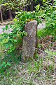
In 1827, King Friedrich August I initiated the renewal of the boundary signs, which then carried the royal crown and the year from 1828 upwards instead of the course swords, as well as a laughing cross on the top. They were smaller than the old stones, not so regular in shape and mostly consisted of granite with only a slightly smooth surface. In many places, however, only the newly determined row numbers were hammered into existing Saxon stones from 1735. From the originally set sandstones with the course swords and the year 1735 Schöne was able to find 68 copies in 2002. Only 14 of them are currently under monument protection (numbers 09304159 and 09287179 on the Saxon list of monuments).
From 1835 stones were also set up to mark the boundaries to and between manors or communities. These stones often have extensive lettering on both sides.

Granite boundary stone after 1827

Boundary stone from 1828 in the Würschnitzer district

Large field stone made of granite to mark a border corner, which today lies in the middle of the forest

Lomnitz boundary stone on the southern Schlägenweg

Border stone Rittergut Radeburg

Triangular manor stone


Use of raw materials and industry
In addition to hunting and forestry, there were other activities in the Laußnitzer Heide. Already for the year 1672 there are reports of charcoal burning in the Laußnitzer and Königsbrücker Heide. Initially, the charcoal was used in particular for iron smelting and glass production. In 1740 there were 19 charcoal burners in the villages of Ottendorf, Moritzdorf and Klein- and Groß-Okrilla, south of the Laußnitzer Heide. After 1945 there were still six charcoal burners in Ottendorf-Okrilla, three of which still existed in 1990. From 1990 to 2010 there was only one charcoal burning plant in town.
In the past, the bogs in the Laußnitzer Heide were also used extensively through peat cutting . There were peat deposits at the foot of the Balzberge and from there to the south and east to Ottendorf-Okrilla and Höckendorf. Peat cuts are still noted on maps from before 1900 between Glauschnitz, Sacka and Tauscha. The production of peat bricks as fuel was stopped in 1909. From then on, peat was only cut for mud baths and for use in gardening centers. In 1947 four peat cutters were still working for the Karl Leonhardt company in Ottendorf-Okrilla, which at that time also operated a charcoal burner and traded in wood and healing earth.
Building sand and gravel from Elbe gravel has been mined in the southern Laußnitz Heath for a long time. The tertiary sands were also used for the production of forest glass . The last pressed glass factory, which last still produced beer mugs for Rastal , existed in Ottendorf-Okrilla until 1991. Due to the development of concrete technology for industry and traffic structures in the greater Dresden area, there was a sharp increase in the demand for sand and gravel from the mid-1920s . From 1950 the gravel pits and the expropriated Max Findeisen charcoal factory were merged to form VEB Heideköhlerei and Ottendorf-Okrilla gravel works. The gravel pit and gravel works have been continuously expanded and technically improved within the Laußnitzer Heide south of the F6 and D9 since the Laußnitz opencast mine was opened up in 1957. After the fall of the Wall , the gravel works on both sides of the B 97 were abandoned and a new plant was built on the site of the gravel pit. The gravel works Ottendorf-Okrilla (KBO) is one of the largest gravel works in the new federal states. The administration is still located on the site of the former gravel works between B 97 and the railway line. In addition, the Sachsen urban railway , which has since been dissolved due to bankruptcy, opened a repair workshop in 2012.
The gravel works is planning extensive expansion of its opencast mines in the long term. In particular, there will be conflicts due to the feared lowering of the groundwater level by the Würschnitz West opencast mine within the next 50 years. This may affect the moors and the forest in the Laußnitzer Heide. A citizens' initiative Würschnitz contra gravel mining has formed as a counterpoint .
Military and other use in restricted areas

The military use of the Laußnitzer Heide began in 1892 when the Saxon Army set up an infantry firing range near Glauschnitz. The course had an extension of around 1.2 km from today's B 98 towards the southwest, was around 0.6 km wide and also covered the intersection of wing H with aisle 15. On this 0.7 km² shooting range Among other things, Alfred Maul's photo rocket, which made it possible to take pictures from a height of around 600 m, was demonstrated to military observers in 1906 . The shooting range was closed in the 1930s and the building leased as a rest home. The military use of the Laußnitzer Heide never reached the dimensions of the Königsbrück military training area founded in 1906 . After 1945 it was only used as a concentration room with over 100 positions and coverings, some of which were also fortified, for tanks and motor vehicles of the Group of the Soviet Armed Forces in Germany (GSSD).
In the 1960s, other areas in the southern Laußnitzer Heide were cordoned off and mainly used by the Ministry of the Interior. Immediately to the east of the railway line, the south supply base (VB Süd, storage object 1) was built. The property took up an area of around 0.15 km², consisted of warehouses, an administration building, a guard building and had a railroad siding. The post towers were dismantled after the fall of the Wall and the area was designated as the Laußnitz Süd industrial park.
Also in the 1960s, storage facility 2 of the supply base south was built around the intersection of wing G with aisle 3. It was an ammunition dump of the district headquarters of the People's Police with an area of around 0.2 km². From 2000, the storage bunkers were used as external storage facilities for the Spreewerk Lübben, which General Atomics had bought . Currently (as of 2020) the warehouse belongs to Maxam Germany. If the Würschnitz West opencast mine were to be expanded, Maxam would have to reduce its stocks for security reasons or temporarily outsource everything completely.
Around 1975, the transmission point ÜSt-2 was built east of aisle 6 (today K 9261) as a protected basic network node for Deutsche Post communication cables for the Dresden district. On the site there was a transmission point with a protected cellar, an emergency power supply and two protected outdoor wells. From 1989 the construction of a new monolithic bunker for the District Operations Command (BEL) of the National People's Army began on the site . Due to the turning point that began in the same year, the bunker did not go beyond the excavation pit. Deutsche Telekom sold the site and building to a private owner in 2011 .
Web links
Individual evidence
- ↑ a b The Laußnitz Heath. Laußnitz municipality, accessed on January 16, 2020 .
- ↑ Olaf Bastian, Ralf-Uwe Syrbe (2005): Natural spaces in Saxony - an overview . Communications from the Saxon Homeland Security Association, special issue. Pages 9-24.
- ↑ a b Friedrich Bernhard Störzner : What the home tells . Arwed Strauch, Leipzig 1904. Chapter 152: The Laußnitzer Heide . Pages 361-362.
- ↑ a b c nature reserve "Laußnitzer Heide". Retrieved January 15, 2020 .
- ↑ Note: "Map of the Ottendorf-Okrilla forest district with Laußnitzer Heide", scale 1: 40000, Verlag Hermann Rühle, Ottendorf-Okrilla, 1930s
- ↑ 34 Laußnitzer Heide on the website www.natura2000.sachsen.de (accessed on June 10, 2020)
- ↑ a b c Friedrich Bernhard Störzner: What the home tells . Arwed Strauch, Leipzig 1904. Chapter 154: The black pond in the Laußnitzer Heide . Pages 364-365.
- ^ A b Friedrich Ludwig Aster (1803): [Miles sheets of Saxony] Saxony Army Engineer Corps (Berlin copy). Scale approx. 1: 12,000.
- ↑ a b c Friedrich Bernhard Störzner: What the home tells . Arwed Strauch, Leipzig 1904. Chapter 153: Desert brands in the Laußnitzer Heide . Pages 363.
- ↑ Cornelius Gurlitt : Nicklasdorf. In: Descriptive representation of the older architectural and art monuments of the Kingdom of Saxony. 35. Issue: Amtshauptmannschaft Kamenz (Land) . CC Meinhold, Dresden 1912, p. 233.
- ↑ a b c d e f Eberhard Barth: Lecture on the forest history of the Laußnitzer Heide. Retrieved January 15, 2020 .
- ↑ WDPA ID 20914 in protectedplanet.net (accessed June 8, 2020)
- ↑ LUPUS Institute for Wolf Monitoring and Research in Germany: Wolf occurrence in Saxony monitoring year 2018/19 , accessed on January 15, 2020
- ↑ a b c d e f g h i j k l m n Eberhard Schöne (2007): The forest boundary stones of the Laußnitzer Heide . In: Between Großer Röder and Kleiner Spree (Museum der Westlausitz Kamenz) Volume 4, Pages 8–39. ISBN 978-3-910018-45-7
- ↑ a b c d Tanja Schumann, Matthias Schrack, Cornelia Mäßler (2015): Results of an inventory of small monuments in the fauna-flora-habitat area "Bog forest area Großdittmannsdorf" . In: 40 years of ornithological and nature conservation work in Großdittmannsdorf (conference proceedings), Museum der Westlausitz Kamenz. Pages 59-74. ISBN 978-3-910018-71-6
- ↑ Horst Torke: Historical boundaries and border signs in Saxon Switzerland: a study based on documents, border descriptions and border protocols from the 15th to 19th centuries including all border stones and border signs recorded in Saxon Switzerland . Saxon printing and publishing house, Dresden 2002. ISBN 978-3-933442-49-9
- ↑ Frank Reichert: On the history of the determination and marking of property and power boundaries in Saxony . Diploma thesis, Geodetic Institute, Technical University Dresden 1999. pdf
- ↑ a b c d e Werner Junitz: Local history . Official journal of the municipality of Ottendorf-Okrilla. October 2018. Page 8. PDF
- ↑ a b c d e f g h i j Gunther Galinsky : On the history of raw material extraction in the Ottendorf-Okrilla area . Freiberg.
- ^ Radeburg. Topographic map (equidistant map) of Saxony (edited in the topographic office of the Royal General Staff). Scale 1:25,000. Giesecke & Devrient, Leipzig 1883.
- ↑ Dietrich Mauerhoff (2014): The forms of the "Pressglaswerke August Walther & Söhne AG" in Ottendorf-Okrilla from 1888 to 1977 . Pressed glass correspondent 1/14. Pages 1-9. PDF
- ↑ KBO history (accessed June 14, 2020)
- ↑ KBO (accessed June 14, 2020)
- ↑ a b c d Obligatory framework operating plan in accordance with Section 52 (2a) BBergG for the plan approval procedure for the Würschnitz-West gravel-sand mine . December 4, 2018. PDF
- ↑ BI Würschnitz versus gravel mining (accessed on June 15, 2020)
- ↑ Altes Lager Geschichtsverein Troop Training Area Königsbrück (accessed on June 15, 2020)
- ↑ Meßtischblatt 35: Königsbrück, recorded in 1901, published in 1904, individual supplements from 1907. Scale 1: 25000. Leipzig 1907.
- ↑ Matthias Knopp: Alfred Maul's photo rocket . In: Ulf Hashagen, Oskar Blumtritt, Helmut Trisckler (eds.): Circa 1903: Artifacts when the Deutsches Museum was founded . Deutsches Museum, Munich 2003. ISBN 978-3-924183-45-5 . Treatises and Reports, NF Volume 19, pages 450-472.
- ↑ a b c d Horst Henkel, Wolfgang Scholz (editor Christian Adam, Martin Erdmann): Restricted areas in the GDR . The Federal Commissioner for the Records of the State Security Service of the Former German Democratic Republic, Berlin 2017. ISBN 978-3-942130-49-3 PDF
- ↑ Material warehouse Ottendorf-Okrilla, VB Süd on Sperrgebiet.eu (accessed on June 15, 2020)
- ↑ a b c Munitionslager BDVP Dresden on Sperrgebiet.eu (accessed on June 15, 2020)
- ↑ a b c d e transmission point Ottendorf-Okrilla ÜSt-2 on Sperrgebiet.eu (accessed on June 15, 2020)
Coordinates: 51 ° 13 ′ 47 " N , 13 ° 50 ′ 33" E