
Koberg
| coat of arms | Germany map | |
|---|---|---|

|
Coordinates: 53 ° 38 ' N , 10 ° 32' E |
|
| Basic data | ||
| State : | Schleswig-Holstein | |
| Circle : | Duchy of Lauenburg | |
| Office : | Secondary sand nuts | |
| Height : | 47 m above sea level NHN | |
| Area : | 11.98 km 2 | |
| Residents: | 783 (Dec. 31, 2019) | |
| Population density : | 65 inhabitants per km 2 | |
| Postal code : | 23881 | |
| Primaries : | 04154, 04543 | |
| License plate : | RZ | |
| Community key : | 01 0 53 069 | |
| LOCODE : | DE 55Q | |
| Office administration address: | Am Amtsgraben 4 23898 Sandesneben |
|
| Website : | ||
| Mayor : | Jörg Smolla (FWK) | |
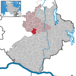
| Location of the municipality of Koberg in the Duchy of Lauenburg | ||
  |
||


Koberg is a municipality in the Duchy of Lauenburg in Schleswig-Holstein, east of Hamburg . Billbaum, Koppelkaten and Schevenböken are in the municipality.
history
It was first mentioned in 1230. The place was long owned by the Hanseatic city of Lübeck . Due to the comparison of 1747 in Hanover, the place fell to the Duchy of Lauenburg . Until 1770 the community had its own chapel belonging to the parish of Nusse. From 1889 Koberg was the seat of the administrative district of the same name. After the dissolution of the administrative districts and the formation of the offices in 1948, the municipality belonged to the Office Nusse , which was added to the Office Sandesneben-Nusse in 2008.
coat of arms
Blazon : "In green above a lowered golden wave bar, a stork in natural colors, with a raised right stand, accompanied by a golden ear and a golden oak leaf."
The wavy bar symbolizes the bill, the ear of wheat, agriculture. The oak leaf stands for the forests in the area. The stork reminds us that until a few years ago numerous storks were breeding in Koberg.
Infrastructure
A parish hall was built in Koberg in 2008. In addition to meeting rooms in the old farm, there is a small shop in the new extension. This is part of the Markttreff concept of the state government of Schleswig-Holstein, which is to ensure the local supply of food in the country. The day care center with crèche and all-day care complete the offer.
In 2009 Koberg was the second state winner in Schleswig-Holstein to win the title “Village with a Future”.
Web links
Individual evidence
- ↑ North Statistics Office - Population of the municipalities in Schleswig-Holstein 4th quarter 2019 (XLSX file) (update based on the 2011 census) ( help on this ).
- ↑ Schleswig-Holstein topography. Vol. 5: Holt - Krokau . 1st edition Flying-Kiwi-Verl. Junge, Flensburg 2005, ISBN 978-3-926055-79-8 , pp. 296 ( dnb.de [accessed on July 20, 2020]).
- ↑ Schleswig-Holstein's municipal coat of arms
Albsfelde | Alt-Mölln | Aumühle | Bäk | Blue | Basedow | Basthorst | Behlendorf | Berkenthin | Besenthal | Bliestorf | Exchanges | Borstorf | Breitenfelde | Bröthen | Brunsmark | Brunstorf | Books | Buchholz | Buchhorst | Dahmker | Dalldorf | Dassendorf | Düchelsdorf | Duvensee | Single house | Elmenhorst | Escheburg | Fitzen | Fredeburg | Fuhlenhagen | Geesthacht | Giesensdorf | Göldenitz | Goddess | Grabau | Grambek | Grinau | Big floor | Great Disnack | Groß Grönau | Great Pampau | Great Sarau | Groß Schenkenberg | Grove | Gudow | Gülzow | Bream | Hamfelde | Hamwarde | Harmsdorf | Havekost | Hohenhorn | Hollenbek | Hornbek | Horst | Juliusburg | Kankelau | Kasseburg | Kastorf | Kittlitz | Klein Pampau | Klein reveler | Plumbing | Klinkrade | Koberg | Kollow | Koethel | Kröppelshagen-Fahrendorf | Krukow | Curved mass | Krüzen | Kuddewörde | Killing | Kulpin | Labenz | Langenlehsten | Lankau | Lance | Lauenburg / Elbe | Clay wheel | Linau | Lüchow | Lütau | Mechow | Möhnsen | Mölln | Mill wheel | Must | Mustin | Niendorf ad St. | Niendorf near Berkenthin | Nuts | Panting | Pogeez | Poggensee | Ratzeburg | Ritzerau | Römnitz | Rondeshagen | Roseburg | Sahms | Salem | Sandesneben | Schiphorst | Schmilau | Schnakenbek | Schoenberg | Schretstaken | Schulendorf | Poking soles | Schwarzenbek | Seedorf | Seven trees | Seven oaks | Sierksrade | Sirksfelde | Steinhorst | Sterley | Stump | Talkau | Tramm | Walksfelde | Wangelau | Wentorf (Amt Sandesneben) | Wentorf near Hamburg | Wiershop | Witzeeze | Wohltorf | Woltersdorf | Worth | Ziethen
Community-free area in the Duchy of Lauenburg
Sachsenwald district