
Dalbek
|
Dalbek Bornbek |
||
 |
||
| Data | ||
| location | District of Duchy of Lauenburg ( Schleswig-Holstein ) and District of Bergedorf ( Hamburg ), Germany | |
| River system | Elbe | |
| Drain over | Knollgraben → Brookwetterung → Schleusengraben → Dove Elbe → Elbe → North Sea | |
| source | as Bornbek in the Sachsenwald west of Dassendorf 53 ° 29 ′ 28 ″ N , 10 ° 20 ′ 10 ″ E |
|
| muzzle | in Altengamme in Knoll trench before it in the Brookwetterung opens coordinates: 53 ° 27 '27 " N , 10 ° 17' 11" O 53 ° 27 '27 " N , 10 ° 17' 11" O
|
|
The Dalbek is a small river that has its source in the southern part of the Duchy of Lauenburg near Dassendorf and flows south via Börnsen and Escheburg to Hamburg-Altengamme . From there the water is fed to the Dove Elbe via the Vierlande rift system.
In some maps it is also incorrectly called "Dallbek". The upper course north of Kröppelshagen is also called Bornbek according to the municipality map. The water condition is very good, even the “European eel” reaches the river when it migrates. In rainy times and when the snow melts , the small, shallow river often turns into a torrent of 6.2 km in length.
course
The source is located in the southern Sachsenwald 780 m west of Dassendorf at 62 m above sea level. NN. After a few meters, the stream, which is now called Bornbek , leaves the community-free area of the Sachsenwald and flows around the Bornberg settlement to the north, before turning to the south-west through the meadows of the Kröppelshagen-Fahrendorf district . It crosses under the B207 at the entrance to Kröppelshagen and flows unevenly through the properties and fields until you reach the state road 208 . After crossing it, the Bornbek is dammed up to become a fire water pond.
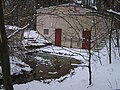
Source with waterworks in the Sachsenwald

The first meters as Bornbek
Bornbek north of the B207

Kröppelshagen fire water pond


From there it flows through a game reserve that borders directly on the Dalbek Gorge nature reserve . This is where the water from a quarry forest that has been dammed up to form a fish pond is taken up. The Dalbek now crosses the nature reserve in the Geesthang near Börnsen and Escheburg, an imposing valley. The Dalbek overcomes a height difference of 38 m at 2850 m. It absorbs the water of some nameless forest streams from various side valleys of the gorge.
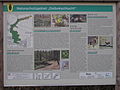
Information board for the Dalbek Gorge nature reserve

The upper, flatter part of the Dalbek Gorge

Away from Börnsen school in the Dalbek gorge
Differences in altitude in the Dalbek Gorge


After leaving the nature reserve, it crosses under the district road 80 (K80, former B5) at a height of 9 m above sea level, passes the westernmost property of Escheburg, the railway line Bergedorf-Geesthacht , the wet meadow area Dröge Wisch, the A25 and again wet meadows. The state border Hamburg / Schleswig-Holstein is also located here on the border of the quarry landscape with the marshland . This runs in the middle of the border ditch into which the Dalbek flows at 3 m above sea level. The border ditch drains through various cross ditches to the Brookwetterung , which flows over the sluice ditch of the Bille to the Dove Elbe .

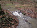
Aftermath of rain and storm

Meander in the Dalbek Gorge

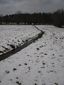
Straightened in the Dröge Wisch wetland area

Inconspicuous confluence with the border ditch


Economical meaning
Most of the spring water is used for drinking water by the Kröppelshagen water supply cooperative. The districts of Bornberg and Kröppelshagen are supplied.