
Stormarn district
| coat of arms | Germany map |
|---|---|

|

Coordinates: 53 ° 43 ' N , 10 ° 20' E |
| Basic data | |
| State : | Schleswig-Holstein |
| Administrative headquarters : | Bad Oldesloe |
| Area : | 766.33 km 2 |
| Residents: | 244,156 (Dec. 31, 2019) |
| Population density : | 319 inhabitants per km 2 |
| License plate : | OD |
| Circle key : | 01 0 62 |
| NUTS : | DEF0F |
| Circle structure: | 55 parishes |
| Address of the district administration: |
Mommsenstrasse 13 23843 Bad Oldesloe |
| Website : | |
| District Administrator : | Henning Görtz ( CDU ) |
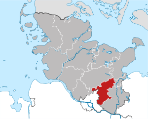
| Location of the Stormarn district in Schleswig-Holstein | |
  |
|
The Stormarn district is a district in the state of Schleswig-Holstein with its seat in Bad Oldesloe . It belongs to the Hamburg metropolitan region .
geography
The Stormarn district borders in the north on the Segeberg district , in the northeast on the Ostholstein district and the independent city of Lübeck , in the east and south on the Duchy of Lauenburg and in the west on the Free and Hanseatic City of Hamburg . Stormarn is one of the six northern peripheral districts in Schleswig-Holstein , which together with the eight southern peripheral districts in Lower Saxony , the two eastern peripheral districts in Mecklenburg-Western Pomerania and the Hanseatic City of Hamburg form the metropolitan region of Hamburg.
The highest point in Stormarn is the Kleine Hahnheider Berg at 100 m above sea level. NN .
history
"Stormarn" can be traced back to the old name of a district , a later county, whose inhabitants were called Stormarii (also Stormere ) as early as the 11th century .
- Stormarn was settled by Saxony until around 600 , the eastern border of Stormarn to today's Duchy of Lauenburg roughly coincides with the historical border between Saxony and Wenden at that time.
- Around 810, Emperor Charlemagne had the Limes Saxoniae (also known as Sachsenwall) built through Stormarn; Remains of a ring wall can still be found at the Nütschauer Schanze today.
- In 1111 Count Adolf von Schauenburg received Holstein , Wagrien and Stormarn as fiefs, with Stormarn at that time being further west than today's district.
- In 1322, with the partition and peace treaty of Oldesloe, the Alster became Stormarn's western border.

- In 1762 the offices of Reinfeld and Rethwisch fell to Denmark .
- In 1773 the old Stormarnic offices of Trittau (not identical to today's office of Trittau), Reinbek and Tremsbüttel became Danish.
- In 1844 the first vocational school was founded in Oldesloe.
- 1867, after the annexation of Schleswig-Holstein to Prussia , were in the province of Schleswig-Holstein 19 counties and a city ( Altona , then called the "City Circle") on the Prussian model formed. Stormarn was one of those circles. It was formed from the old lordly offices of Reinbek , Reinfeld , Rethwisch , Tremsbüttel and Trittau (not identical to the current office of Trittau), the city of Bad Oldesloe , the municipalities of Wandsbek and Reinfeld , 17 noble estates and the lübschen enclaves included in the area . The administrative seat was initially Reinbek . The district area was divided into four parish bailiffs, to which the rural communities were assigned. The noble estates were converted into manor districts .
- From 1867 to 1873 the seat of the district administration was in Reinbek Castle .
- In 1873 Wandsbek became the new seat of the district administration.
- In 1889, the Prussian municipal constitution of May 26, 1888 brought a new district order: Instead of the four parish bailiffs, there were now 26 administrative districts , into which the 127 rural communities of the district were classified. In addition, the 21 manor districts, the city of Oldesloe and the areas of Wandsbek and Reinfeld existed as non-official regional authorities.
- In 1889 the district vocational school was founded in Bad Oldesloe (the Ahrensburg branch became independent in 1980),
- The agricultural school opened in 1898 (closed in 1994).
- In 1901 Wandsbek became an independent city , but remained the seat of the district administration.
- On October 23, 1923, as part of the Hamburg uprising of the KPD, the mayor Bargteheides was arrested and the Soviet republic of Stormarn was proclaimed. The republic was crushed by soldiers from Lübeck the very next day.
- The Lower Elbe Law of 1927 united u. a. Lohbrügge with sand and created the new large community of Billstedt from the communities of Schiffbek, Öjendorf and Kirchsteinbek .
- In 1937 Stormarn lost about half of its inhabitants with twelve peripheral communities (including Rahlstedt , Billstedt and Lohbrügge ) to Hamburg through the Greater Hamburg Act . The municipality of Großhansdorf -schenbeck, which belongs to Hamburg , fell to Stormarn. The seat of the district administration remained in the Stormarnhaus in Hamburg-Wandsbek.
- In 1943, following the destruction of the district administration building due to the effects of the war, the administration was moved from Wandsbek to Bad Oldesloe.
- 1945 The military occupation of Stormarn by British troops took place in the last week of the war, from May 1st to 3rd, 1945. On the afternoon of May 3rd, the occupation of Hamburg began , which had previously been agreed in the Villa Möllering near Lüneburg . One day later, Hans-Georg von Friedeburg signed the surrender of all German troops in north-west Germany, the Netherlands and Denmark on behalf of the last Reich President Karl Dönitz , who had previously left for Flensburg - Mürwik with the last Reich government . The unconditional surrender of the Wehrmacht followed on May 8th
- In 1948, the new district order of the British military government replaced the Prussian administrative districts with the new offices .
- In 1949 Bad Oldesloe officially became the seat of the district administration.
- In 1951, the Stormarn district council elected Erika Keck, the first woman in Schleswig-Holstein to be district president .
- In 1952 the construction of today's Stormarnhaus began on the station forecourt in Bad Oldesloe. The first Stormarnhaus is now home to the Wandsbek district office in Hamburg.
- In 1957, the district founded what is now Germany's oldest business development company , the "Stormarn Economic and Development Company", WAS.
- In 1970 the city of Norderstedt was formed from the Stormarner communities Glashütte and Harksheide and the Pinneberger communities Garstedt and Friedrichsgabe and added to the Segeberg district.
- In the 1970s, the municipal reorganization led to a reduction in the number of offices to 5 and the number of municipalities belonging to the office to 44. In addition, there are 6 cities and 5 municipalities without offices.
- In 1976, the increased space requirement made a further administrative building in Bad Oldesloe on Mewesstrasse necessary.
- In 1985 the road traffic authority / registration office in Bad Oldesloer Rögen industrial area moved into its own building with sufficient parking space after it was much too narrow in Mommsenstraße.
- In 1991 the Senate of the Free and Hanseatic City of Hamburg , the state government of Lower Saxony and the state government of Schleswig-Holstein decided to intensify their cooperation in the Hamburg metropolitan region . Stormarn has been a member of the Hamburg metropolitan region since then.
- In 1996, Europe's largest fruit and woodland nature trail was established over a length of 4 km between Grabau and Blumendorf near Bad Oldesloe.
- In 1997 the district administration in Bad Oldesloe had grown to seven administration buildings with the new building at the train station; six of them are in the immediate vicinity of the train station, another building (registration office) is in the Rögen industrial park.
- The Stormarn district has also been on the Internet since 1998.
- In 1998, the Stormarn district was the first in Schleswig-Holstein to elect its district administrator in a direct election.
- In 2006, the Stormarn and Duchy of Lauenburg districts set up a joint rescue control center in Bad Oldesloe (commissioning on March 1, 2006).
- In 2013, the Stormarn, Duchy of Lauenburg and Ostholstein districts set up the Integrated Regional Control Center South (IRLS South) for the fire brigade, rescue service and disaster control based in Bad Oldesloe (commissioning in February 2013).
Population development in the respective district area
The population figures refer to the respective territorial status.
| year | Residents | source |
|---|---|---|
| 1867 | 62,281 | |
| 1890 | 79,570 | |
| 1900 | 96,069 | |
| 1910 | 85.851 | |
| 1925 | 97.090 | |
| 1933 | 111,460 | |
| 1939 | 67,789 | |
| 1946 | 144.056 | |
| 1950 | 146.431 | |
| 1960 | 140,400 | |
| 1970 | 157,000 | |
| 1980 | 187,400 | |
| 1990 | 198,600 | |
| 2000 | 217,582 | |
| 2010 | 229,756 |
Population development today’s territory
The population figures up to 1970 refer to the area on May 27, 1970.
|
|
Denomination statistics
According to the 2011 census , 42.4% of the population were Protestant , 6.7% Roman Catholic and 50.8% were non-denominational , belonged to another religious community or did not provide any information.
politics
District council
The last local elections had the following results:
| Parties, constituencies and individual applicants |
% 2018 |
Seats 2018 |
% 2013 |
Seats 2013 |
% 2008 |
Seats 2008 |
% 2003 |
Seats 2003 |
% 1998 |
Seats 1998 |
|
| CDU | Christian Democratic Union of Germany | 35.9 | 24 | 41.12 | 22nd | 41.29 | 28 | 52.85 | 29 | 41.93 | 21st |
| SPD | Social Democratic Party of Germany | 21.6 | 14th | 29.97 | 16 | 27.31 | 17th | 28.98 | 15th | 43.58 | 22nd |
| GREEN | Alliance 90 / The Greens | 18.9 | 12 | 16.53 | 9 | 13.06 | 8th | 10.55 | 5 | 9.16 | 4th |
| FDP | Free Democratic Party | 8.4 | 5 | 6.19 | 3 | 10.19 | 6th | 6.37 | 3 | 5.33 | 2 |
| AfD | Alternative for Germany | 6.6 | 4th | - | - | - | - | - | - | - | - |
| THE LEFT. | The left | 4.3 | 3 | 2.74 | 1 | 6.31 | 4th | - | - | - | - |
| FREE VOTERS | Free voters | 1.9 | 1 | - | - | - | - | - | - | - | - |
| Forum 21 | Forum 21 political association in Stormarn | 1.2 | 1 | 2.87 | 2 | 1.69 | 1 | 1.25 | 0 | - | - |
| FAMILY | Family party of Germany | 0.7 | 0 | - | - | - | - | - | - | - | - |
| UWA | Independent voter community Ammersbek | 0.5 | 0 | 0.23 | 0 | - | - | - | - | - | - |
| DKP | German Communist Party | 0.0 | 0 | - | - | - | - | - | - | - | - |
| EB | Individual applicant Kleinschmidt | - | - | 0.28 | 0 | - | - | - | - | - | - |
| Consumer sch. | Consumer protection
Political party |
- | - | 0.07 | 0 | 0.07 | 0 | - | - | - | - |
| EB | Michahelle's single applicant | - | - | - | - | 0.10 | 0 | - | - | - | - |
| total | 100.0 | 64 | 100.0 | 53 | 100.0 | 64 | 100.0 | 52 | 100.0 | 49 | |
| Voter turnout in% | 48.6 | 47.6 | 50.8 | 56.9 | 63.2 | ||||||
District administrators
- 1868–1880: Wilhelm von Levetzau
- 1880–1887: Karl von Hollen
- 1887–1894: Detlev von Bülow , Free Conservative Party
- 1894–1918: Joachim von Bonin , Free Conservative Party
- 1919–1933: Friedrich Knutzen , DDP
- 1933–1936: Constantin Bock von Wülfingen , NSDAP
- 1937–1940: Erich Keßler
- 1940–1942: Rolf Breusing , NSDAP
- 1942–1943: Karl von Lamprecht (District Administrator of the Steinburg district on behalf of)
- 1943–1945: Rolf Carls (acting)
- 1945: Kock (acting)
- 1945–1946: Wilhelm Paasche
- 1946: Heinrich Eckholdt
- 1946–1956: Wilhelm Siegel , SPD
- 1956–1957: Klaus von der Groeben , CDU
- 1957–1975: Wennemar Haarmann , CDU
- 1975–1989: Hans-Henning Becker-Birck , CDU
- 1990–1998: Hans Jürgen Wildberg , independent
- 1998–2016: Klaus Plöger , SPD
- since 2016: Henning Görtz , CDU
District Presidents
- 1950–1951: Otto Gramcko , SPD
- 1951–1955: Erika Keck , CDU
- 1955–1974: Friedrich Hardt , CDU
- 1974–1998: Hubert Priemel , CDU
- 1998–2003: Ursula Stielau , SPD
- 2003–2013: Christa Zeuke , CDU
- since 2013: Hans-Werner Harmuth , CDU
coat of arms
Blazon : "In red a silver swan striding to the right in a fighting stance with raised wings and a golden crown around the neck."
The coat of arms has been recorded in the seal of the Danish royal family for the Stormarn region (county, principality) since the late 15th century and is one of the oldest regional coats of arms in Germany.
flag
Blazon : "On a red flag - turned to a pole on both sides - the white Stormarn swan with a yellow crown."
Economy and Infrastructure
The Stormarn district is economically strongly determined by the two neighboring cities of Hamburg and Lübeck, it counts in large parts (south and west) of the " bacon belt " of Hamburg, which is reflected in the demographic development (population growth from 163,000 inhabitants in 1973 to currently over 220,000 Residents) as well as in the settlement of many trades and industries. In contrast, the north-east of the district is mainly characterized by agriculture.
According to GfK surveys for 2016 and 2017, the district was one of the ten districts with the highest purchasing power in Germany and ranked tenth nationwide. In 2018, the Stormarn district was ranked 17th in a nationwide comparison of the regions. In the Future Atlas 2016 , the Stormarn district was ranked 75th out of 402 districts and urban districts in Germany, making it one of the districts with “high future prospects”.
Fifty years ago (March 23, 1957) the Stormarn district founded what is now Germany's oldest business development company - the Stormarn Economic and Development Company (WAS) .
The elongated shape of the district area on the one hand and the large population concentration in the communities in the southwest of the district (Reinbek, Glinde, Barsbüttel) on the other hand are unfavorable for the district structure. This often leads to long journeys for citizens. The district is now trying to compensate for this through administrative cooperation with the respective city and district administrations.
traffic
The location of the district along the motorways 1 (“ Vogelfluglinie ”), 24 (Hamburg– Berlin ), 20 (Lübeck– Rostock ), 21 ( Bargteheide - Kiel ) is decisive for traffic . On the railways, the Hamburg-Lübeck railway line is important, from which Bad Oldesloe u. a. the connection to Neumünster branches off. The local public transport in the district was incorporated into the HVV in 2003 .
Major airports in the vicinity are Hamburg southwest and Lübeck east of the district.
education
The Stormarn district is responsible for two vocational schools, one in Ahrensburg and one in Bad Oldesloe. The vocational school in Bad Oldesloe is a project school for the “Regional Vocational Training Centers” concept, or RBZ for short. These should be more independent of their wearer and be able to make many decisions themselves. The school is already organized like a company, which means that it should be able to work more effectively due to improved delegation and participation of the students. The name of the vocational school in the district in Bad Oldesloe is "RBZ Nordstormarn".
Culture
Architectural monuments
tourism
Communities
(Residents on December 31, 2019)
| Municipalities not in office | ||
|---|---|---|
|
|
|
Offices with official municipalities (* = seat of the official administration)
|
|
|
The municipality Tangstedt (6485 inhabitants) is the official Itzstedt , Kreis Segeberg managed.
Municipality and office map


Büttenwarder
The district has another municipality on its website: Büttenwarder (based on the TV series News from Büttenwarder ) is listed there as a virtual municipality with the postcode 22999.
Former parishes
The following municipalities in the Stormarn district were incorporated into other municipalities or left the district during its existence:
Until it was dissolved in the 1920s, there were also a number of manor districts in the Stormarn district .
Protected areas
There are 17 designated nature reserves in the district (as of February 2017).
License Plate
On July 1, 1956, the district was assigned the distinctive symbol OD (Bad Oldesloe) when the license plates that are still valid today were introduced . It is still issued today.
literature
- Günther Bock, Hans-Jürgen Perrey , Michael Zapf : Stormarn. History, country and people. Medien-Verlag, Hamburg 1994, ISBN 3-929229-22-6 .
- Norbert Fischer : From the Hamburg area to the metropolitan region. Stormarn's history since 1980. DOBU-Verlag, Hamburg 2008, ISBN 3-934632-31-9 .
- Norbert Fischer: The modeled region. On the history of Stormarn and the Hamburg area from the Second World War to 1980. Neumünster 2000, ISBN 3-529-07099-8 .
- Norbert Fischer, Franklin Kopitzsch , Johannes Spallek : From rural living environments to metropolitan regions. Regional history using the example of Stormarn. Neumünster 1998.
- Barbara Günther (Ed.): Stormarn Lexicon. Neumünster 2003, ISBN 3-529-07150-1 .
- Helmuth Peets: Stormarn is worth a trip. Oho Verlag, Bad Oldesloe 1999, ISBN 3-9804959-1-4 .
- Werner Scharnweber: Stormarn district. Travel pictures. Edition Temmen, Bremen 2006, ISBN 3-86108-946-7 .
- Johannes Spallek: Stormarn between Alster and Bille . Wachholtz Verlag, Neumünster 1994, ISBN 3-529-05512-3 .
Web links
- Website of the Stormarn district
- Link catalog on the Stormarn district at curlie.org (formerly DMOZ )
- History since 1945
- Literature from and about the Stormarn district in the catalog of the German National Library
- Holdings of the Stormarn district archive in the archive portal-D
Individual evidence
- ↑ a b Statistics Office North - Population of the municipalities in Schleswig-Holstein 4th quarter 2019 (XLSX file) (update based on the 2011 census) ( help ).
- ↑ Ordinance on the organization of the district and district authorities, as well as the district representation in the province of Schleswig-Holstein of September 22, 1867, PrGS 1867, 1587
- ↑ Hamburger Abendblatt : End of the war. Seventy years ago the city of Ahrensburg surrendered on: May 2nd, 2015; accessed on: May 31, 2017
- ↑ The surrender on the Timeloberg (PDF, 16 S .; 455 kB)
- ^ Stormarn district - GenWiki . In: wiki-de.genealogy.net .
- ↑ a b c d e f g h i Michael Rademacher: German administrative history from the unification of the empire in 1871 to the reunification in 1990. stormarn.html. (Online material for the dissertation, Osnabrück 2006).
- ↑ 1946 census
- ^ Jochen Kothe: I. Territory and population . In: Statistical Yearbook for the Federal Republic of Germany (via www.digizeitschriften.de) . 1972, December 29, 1973, pp. 23-40.
- ^ Jochen Kothe: DigiZeitschriften: Side view . In: www.digizeitschriften.de .
- ↑ a b North Statistics Office . In: www.statistik-nord.de .
- ↑ State Statistical Office Schleswig-Holstein (ed.): The population of the communities in Schleswig-Holstein 1867 - 1970 . State Statistical Office Schleswig-Holstein, Kiel 1972, p. 21 .
- ^ District Stormarn Religion , 2011 census
- ↑ Result of the district election 2018 in the Stormarn district. (PDF) Retrieved June 9, 2018 .
- ↑ a b District election 2018 (election evening). Retrieved May 10, 2018 .
- ↑ a b http://www.kreis-stormarn.de/kreis/wahlen/verbindungen/kw2013/ErresultKreiswahl2013.pdf
- ↑ a b http://www.kreis-stormarn.de/kreis/wahlen/verbindungen/kw2008/ErresultKreiswahl2008.pdf
- ↑ a b http://www.kreis-stormarn.de/kreis/wahlen/files/kw2003/result_kommunalwahl_2003.pdf ( Memento from October 30, 2012 in the Internet Archive )
- ↑ a b http://www.kreis-stormarn.de/kreis/wahlen/files/kw1998/kommwahl_1998.pdf ( Memento from October 30, 2012 in the Internet Archive )
- ↑ a b Schleswig-Holstein's municipal coat of arms
- ↑ Purchasing power of Germans increases by 2 percent in 2016. GfK , December 15, 2015, accessed on December 1, 2016 .
- ↑ Purchasing power Germany 2018. GfK , December 12, 2017, accessed on February 23, 2018 .
- ↑ Future Atlas 2016. (No longer available online.) Archived from the original on October 2, 2017 ; accessed on March 23, 2018 .
- ↑ State Statistical Office Schleswig-Holstein (Ed.): The population of the communities in Schleswig-Holstein . Historical register of municipalities: Stormarn district. Kiel 1972 ( digitized from genealogy.net [accessed on April 21, 2015]).
- ↑ Welcome to Gemeindeververzeichnis.de . In: ulischubert.de .
Independent cities: Flensburg | Kiel | Lübeck | Neumunster
Districts: Dithmarschen | Duchy of Lauenburg | North Friesland | Ostholstein | Pinneberg | Plön | Rendsburg-Eckernförde | Schleswig-Flensburg | Segeberg | Stone castle | Stormarn