
Siek (Holstein)
| coat of arms | Germany map | |
|---|---|---|

|
Coordinates: 53 ° 38 ' N , 10 ° 18' E |
|
| Basic data | ||
| State : | Schleswig-Holstein | |
| Circle : | Stormarn | |
| Office : | Siek | |
| Height : | 57 m above sea level NHN | |
| Area : | 12.47 km 2 | |
| Residents: | 2457 (Dec. 31, 2019) | |
| Population density : | 197 inhabitants per km 2 | |
| Postal code : | 22962 | |
| Area code : | 04107 | |
| License plate : | OD | |
| Community key : | 01 0 62 069 | |
| Office administration address: | Hauptstrasse 49 22962 Siek |
|
| Website : | ||
| Mayor : | Andreas Bitzer ( CDU ) | |
| Location of the community of Siek in the Stormarn district | ||
  |
||

Siek is a municipality in the Stormarn district in Schleswig-Holstein . The districts of Fleischgaffel, Siekerfeld and Meilsdorf belong to the community. Siek is the administrative seat of the office of the same name .
geography
Siek is northeast of Hamburg . The federal highway 1 runs through the municipality. The Wandse flows through the municipality.
In Siek there was a stop on the Südstormarn circular path . After the switch to bus operation, the transport connections were taken over by the VHH in the 1950s .
history
The Friedenskirche in Siek was probably first built in the 13th century. Your altar dates from the 17th century. After the church burned down after a lightning strike, it was rededicated in 1883.
In 1813 the Danish troops were defeated in the Battle of Siek .
On February 1, 1974, the community Meilsdorf was incorporated.
On January 1st, parts of the area with then around 50 inhabitants were ceded to the neighboring municipality of Großhansdorf .
politics
Municipal council and mayor
In the local elections on May 6, 2018, the CDU achieved an absolute majority with an election result of 50.7%. The SPD gained 35% and the FDP 14.3%. The turnout of 59.4% was well above the national average. At the constituent meeting of the municipal council on June 12, 2018, the CDU mayor candidate Andreas Bitzer was elected mayor with eight votes, ahead of Arnold Trenner (SPD, four votes) and Elena Grimmer (FDP, one vote).
| Electoral term | CDU | SPD | FDP | mayor |
|---|---|---|---|---|
| 2018 to 2023 | 7th | 4th | 2 | Andreas Bitzer (CDU) |
| 2013 to 2018 | 6th | 6th | 1 | Arnold Trenner (SPD) |
| 2008 to 2013 | 5 | 4th | 4th | Arnold Trenner (SPD) |
| 2003 to 2008 | 7th | 4th | 2 | Peter Rönner (CDU) |
coat of arms
Blazon : "In red the silver Sieker Church (elevation of the tower front), accompanied by three golden ears of corn, the two inner ears of which are inclined towards the church, and by the silver Stormarn swan with the golden crown on the upper left."
Culture and sights
- The first previous building of the Friedenskirche in Siek was built from field stone in the 13th century, rebuilt in neo-Gothic style after a fire in 1880 and extensively renovated between 1954 and 1956.
- The two-column half-timbered house from 1792 in Meilsdorf is the oldest house in the Stormarn district.
- Galerieholländer windmill in the Fleischgaffel district

Friedenskirche

Half-timbered house from 1792 in Meilsdorf

Windmill in meat gaff
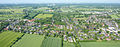
Aerial view of the community in west direction; Siek district in the foreground, Meilsdorf district in the background (location Ohlenstücke / L 224)


Web links
Individual evidence
- ↑ North Statistics Office - Population of the municipalities in Schleswig-Holstein 4th quarter 2019 (XLSX file) (update based on the 2011 census) ( help on this ).
- ↑ Schleswig-Holstein topography. Vol. 9: Schönberg - Tielenhemme . 1st edition Flying-Kiwi-Verl. Junge, Flensburg 2007, ISBN 978-3-926055-91-0 , p. 104 ( dnb.de [accessed on July 31, 2020]).
- ↑ a b Federal Statistical Office (ed.): Historical municipality register for the Federal Republic of Germany. Name, border and key number changes in municipalities, counties and administrative districts from May 27, 1970 to December 31, 1982 . W. Kohlhammer, Stuttgart / Mainz 1983, ISBN 3-17-003263-1 , p. 186 f .
- ↑ Schleswig-Holstein's municipal coat of arms
Ahrensburg | Ammersbek | Bad Oldesloe | Badendorf | Bargfeld bridges | Bargteheide | Barnitz | Barsbüttel | Braak | Brunsbek | Delingsdorf | Elmenhorst | Feldhorst | Glinde | Grabau | Grande | Grönwohld | Großensee | Großhansdorf | Hamberge | Hamfelde | Hammoor | Heidekamp | Heilshoop | Hohenfelde | Hoisdorf | Jersbek | Klein Wesenberg | Koethel | Lasbek | Lütjensee | Meddewade | Mönkhagen | Neritz | Nienwohld | Oststeinbek | Pölitz | Rausdorf | Rehhorst | Reinbek | Reinfeld (Holstein) | Rethwisch | Lumber | Siek | Stacking field | Stone castle | Tangstedt | Todendorf | Travenbrück | Tremsbüttel | Trittau | Wesenberg | Westerau | Joke | Zarps