Elmenhorst (Stormarn)
| coat of arms | Germany map | |
|---|---|---|

|
Coordinates: 53 ° 46 ' N , 10 ° 16' E |
|
| Basic data | ||
| State : | Schleswig-Holstein | |
| Circle : | Stormarn | |
| Office : | Bargteheide country | |
| Height : | 30 m above sea level NHN | |
| Area : | 14.93 km 2 | |
| Residents: | 2710 (Dec. 31, 2019) | |
| Population density : | 182 inhabitants per km 2 | |
| Postal code : | 23869 | |
| Area code : | 04532 | |
| License plate : | OD | |
| Community key : | 01 0 62 016 | |
| Address of the municipal administration: |
Eckhorst 34 22941 Bargteheide |
|
| Website : | ||
| Mayor : | Norbert Ohl (UBE) | |
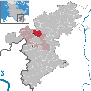
| Location of the municipality of Elmenhorst in the Stormarn district | ||
Elmenhorst is a municipality in the Stormarn district in Schleswig-Holstein . The community consists of the districts Elmenhorst, Fischbek and Mönkenbrook.
geography
Elmenhorst is on the federal highway 75 between Bargteheide and Bad Oldesloe .
history
Elmenhorst
In 1346 Elmenhorst was first mentioned in a document without any doubt. (If it was mentioned in 1230, it is unclear whether the Elmenhorst in Lauenburg is meant). Until its division in 1588, the place belonged to the possessions of the noble estate Borstel , then to the noble estate Jersbek . In 1873 Elmenhorst became a rural community in the parish vogue district of Bargteheide in the Stormarn district . With the final introduction of the Prussian municipal constitution in 1889, Elmenhorst came to the Jersbek district . Since 1948 it has belonged to the Bargteheide-Land office .
Fischbek
Fischbek was first mentioned in 1321 when the Knight of Hammoor sold it. Fischbek later belonged to the old lordly office of Tremsbüttel . In the 16th century the village was temporarily pledged to the noble estate Höltenklinken . In 1867 Fischbek came as a rural community to the parish bailiwick of Bargteheide , with the introduction of the Prussian municipal constitution in 1889 to the district of Bargteheide . In 1924/25 the Tremsbüttel enclaves Domskuhlen and Eckhorst were incorporated. From 1948 Fischbek was part of the Bargteheide-Land office .
Incorporations
On January 1, 1978, Fischbek was incorporated into Elmenhorst.
politics
Community representation
Of the 17 seats in the municipal council, the UBE voter community has had six seats since the 2018 local elections, the CDU and the BGE voter community each have four seats and the SPD has three seats.
coat of arms
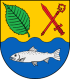
Blazon : “Divided by gold and blue in a wave cut. At the top right a slanted green elm leaf, at the top left a red sword and a red crook, at the bottom a silver trout. "
Economy and Infrastructure
The community is connected to the national road network via the federal highway 75 ( Hamburg - Lübeck ). With the regional bus service operated by Autokraft , Elmenhorst and Fischbek can also be reached by public transport; the journeys are made within the Hamburg transport association HVV.
There are two volunteer fire brigades in the community , one in Elmenhorst and one in Fischbek.
The schools that have been documented since 1749 (Fischbek) and 1751 (Elmenhorst) were closed in 1969. Since then, the children have been taught at the Johannes Gutenberg School in Bargteheide during primary school. The secondary schools are then also visited in Bargteheide.
There are two general sports clubs in the municipality, the SC Elmenhorst and the JuS Fischbek .
There is also the Elmenhorst tennis club , the shooting club from Elmenhorst and the surrounding area, and the Mittelstormarn riding and driving club . In 2003 the largest western riding school in northern Germany was opened in Fischbek, the American Training Stable .
Besides offering Elmenhorst with the mixed choir , the Elmenhorster band and the orchestra Elmenhorst a wide range of musical activities.
The Low German Theater Association Elmenhorst regularly puts on plays in the multi-purpose building.
Personalities
- Heinrich Wolgast (1905–1982), politician ( FDP )
Web links
Individual evidence
- ↑ North Statistics Office - Population of the municipalities in Schleswig-Holstein 4th quarter 2019 (XLSX file) (update based on the 2011 census) ( help on this ).
- ↑ Schleswig-Holstein topography. Vol. 3: Ellerbek - Groß Rönnau . 1st edition Flying-Kiwi-Verl. Junge, Flensburg 2003, ISBN 978-3-926055-73-6 , p. 20 ( dnb.de [accessed April 17, 2020]).
- ^ Federal Statistical Office (ed.): Historical municipality directory for the Federal Republic of Germany. Name, border and key number changes in municipalities, counties and administrative districts from May 27, 1970 to December 31, 1982 . W. Kohlhammer GmbH, Stuttgart / Mainz 1983, ISBN 3-17-003263-1 , p. 187 .
- ↑ Schleswig-Holstein's municipal coat of arms


