
Ammersbek
| coat of arms | Germany map | |
|---|---|---|

|
Coordinates: 53 ° 41 ′ N , 10 ° 12 ′ E |
|
| Basic data | ||
| State : | Schleswig-Holstein | |
| Circle : | Stormarn | |
| Height : | 35 m above sea level NHN | |
| Area : | 17.71 km 2 | |
| Residents: | 9848 (Dec. 31, 2019) | |
| Population density : | 556 inhabitants per km 2 | |
| Postal code : | 22949 | |
| Primaries : | 040, 04102, 04532 | |
| License plate : | OD | |
| Community key : | 01 0 62 090 | |
| LOCODE : | DE AMS | |
| Address of the municipal administration: |
Am Gutshof 3 22949 Ammersbek |
|
| Website : | ||
| Mayor : | Horst Ansén ( SPD ) | |
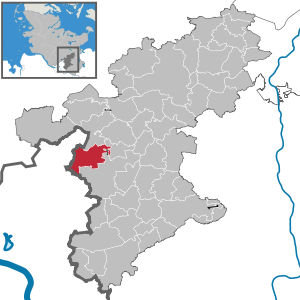
| Location of the municipality of Ammersbek in the Stormarn district | ||
  |
||

Ammersbek is a municipality in the Stormarn district in Schleswig-Holstein and borders the Bergstedt district in the northeast of Hamburg and is part of the Hamburg metropolitan region . The community was named after the Ammersbek stream that flows through its area.
geography
The municipality of Ammersbek borders in the west with its district Lottbek on Hamburg-Bergstedt , in the north on the municipality Jersbek , in the east on the municipality Delingsdorf and in the south on the municipality Ahrensburg .
The community consists of five districts, in the western district of Lottbek and Hoisbüttel and in the eastern part Daheim / Heimgarten, Bünningstedt and Rehagen / Schäferdresch.
The Heidkoppelmoor nature reserve and the surrounding area is located in the Hoisbüttel district . The actual moor is a so-called intermediate moor depression with adjacent wet grassland areas that provide a home for many animal and plant species. In addition, the surrounding meadows, forests and pastures are also under protection. The area has been under nature protection since 1995 .

The Schüberg is 63 meters high, a steep mountain upstanding pointed cone and together with the Bockberg (63 feet high) south of the Bredenbeker pond part of a moraine , which in the Weichselian arose. Because of its geological and ecological importance, it was designated by the Stormarn district in 1987 as a protected landscape component under Section 18 of the State Nature Conservation Act. The Schüberg is also shown in the coat of arms of the municipality of Ammersbek.
The municipality of Ammersbek is traversed by the Bredenbek , Ammersbek , Hunnau , Bunsbach, Moorbek and Lottbek brooks . The Bredenbek is fed by the Bredenbeker pond and flows into the Alster in the Hamburg area . The Hunnau emerging in Ahrensburg and the Bunsbach coming from Bargteheide unite north of the Lübecker Landstrasse, halfway between Hoisbüttel and Rehagen / Schäferdresch to the Ammersbek, which flows into the Alster in Hamburg. For the most part of its course, the Moorbek forms the border between Hamburg and Ahrensburg / Schleswig-Holstein and, shortly after reaching the Ammersbek area, joins the Deepenreihengraben to the Lottbek. This first flows through the Lottbeker reservoir, then through the Ammersbeck district of Lottbek and finally flows into the Homdiek pond in Hamburg. There it unites with the Bredenbek. The Lottbek is eponymous for the district Lottbek.
history
The community was created on January 1, 1978 through the merger of Bünningstedt and Hoisbüttel, which were previously administered by the Bünningstedt office.
Lottbek
Already in the 14th century there was a village Lottbek , which was named after the brook Lottbek , a tributary of the Bredenbek . The village, which had been owned by Hamburg since 1437, died out in 1535 due to a plague epidemic . In the period that followed, there were disputes between Hamburg and Gut Hoisbüttel over the use of the land.
With the commissioning of the small railway line between Volksdorf and Wohldorf with the Lottbek stop in 1907, the development of the Hoisbüttler district of Lottbek began. After the expansion of the Hamburg underground line U1 to the then Hamburg exclave Ohlstedt , the Walddörferbahn with the underground station Hoisbüttel in the years between 1919 and 1927 and the double-track expansion of the entire line to Ohlstedt in 1954 the village of Lottbek became a denser settlement. This district around the Hoisbüttel underground station in the municipality of Ammersbek is now the most densely populated.
In order to counteract plans for an expansion of the settlement area and the development of the last local recreation and green areas in this district, the citizens' initiative Livable Lottbek (BILL) was formed in 2008 from the NABU local group in Ammersbek . Its aim is the protection and care of the environment and nature with special consideration of the wild bird life as well as the promotion of nature-related landscape care.
Bünningstedt
Bünningstedt was first mentioned in a document in 1314. 1442 bought the Cistercian - Kloster Reinbek the village, which it in 1567 along with the convent Bailiwick Woldenhorn to the family Rantzau sold. This incorporated it into the noble estate Ahrensburg . In 1765 Bünningstedt was coupled , serfdom was revoked in 1788. After the introduction of the Prussian municipal constitution , the place came to the Ahrensburg district in 1889 and to the Bergstedt district in 1931. When this was dissolved in 1937 as a result of the Greater Hamburg Act , Bünningstedt went back to Ahrensburg.
In the 1930s, the place began to change from a farming village to a Hamburg suburb. The Daheim and Heimgarten settlements emerged. After the Second World War, the district was converted into the Ahrensburg office, but Bünningstedt left the office in 1951 and formed the Bünningstedt office with Hoisbüttel. In the period that followed, the Rehagen, Schäferdresch and Bramkamp settlements emerged, which developed from homes for displaced people and bombed-out Hamburgers.
Hoisbüttel

Hoisbüttel was first mentioned in a document in 1262. In 1370 the village was owned by the Rantzau family . In 1396 the village passed into the possession of the squire Bruneke von Alversloe , who in 1437 pledged half of the village to Hamburg, which formed one of the Hamburg forest villages . Between 1600 and 1810, the noble Hoisbüttel estate changed hands probably fifteen times. When Count Peter Friedrich Adolph von Schmettau and Countess Hedwig von Schmettau (1792–1858) took over the estate in 1810, the relationship between the landowners and the population improved fundamentally. The estate remained in the possession of the Schmettau until 1857. Out of gratitude to the Countess, the community put a memorial stone in her honor on the Schüberg in 1867.
Since the end of the 17th century there is evidence of a school in the Holstein part. The coupling took place there in 1792. In 1803 the hamburg half of the village also came to Holstein and, like the estate, belonged to the old lordly Tremsbüttel office. Both parts of the village remained administratively independent until 1926. Since the Prussian province of Schleswig-Holstein was founded in 1867, both parts of Hoisbüttel have belonged to the Stormarn district . With the introduction of the Prussian municipal constitution in 1889, they came to the Bergstedt district. When this was dissolved due to the Greater Hamburg Law in 1937, the now reunified rural community came to the district of Ahrensburg. In 1951, Hoisbüttel left the Ahrensburg office and formed the Bünningstedt office with Bünningstedt, from which the Ammersbek community emerged in 1978.
local community
Center of the municipality Ammersbek

.ajb.jpg)
In the middle of the Hoisbüttel district, on the former farm yard of the Hoisbüttel estate, the center of the municipality of Ammersbek is located with the town hall, the village community center and the building yard as well as a festival meadow. The town hall and the building yard were built around 1986/87, the village community center arose from the two-storey horse stable built around 1906, which contains an event hall for around 240 places.
Population development
Population development before the merger of Bünningstedt and Hoisbüttel:
| year | Bünningstedt | Hoisbüttel |
|---|---|---|
| 1850 | 325 | |
| 1900 | 455 | |
| 1925 | 336 | |
| 1933 | 316 | 588 |
| 1939 | 1.004 | 741 |
| 1946 | 2,096 | 1,469 |
| 1950 | 1,651 | |
| 1978 | 3,386 | 4,351 |
Population development in the municipality of Ammersbek from 2003 to 2019
| year | number | year | number |
|---|---|---|---|
| 2003 | 9,178 | 2011 | 9,355 |
| 2004 | 9,167 | 2012 | 9,422 |
| 2005 | 9,238 | 2013 | 9,425 |
| 2006 | 9,209 | 2014 | 9,706 |
| 2007 | 9.133 | 2015 | 9,682 |
| 2008 | 9,311 | 2016 | 9,724 |
| 2009 | 9 313 | 2018 | 9,770 |
| 2010 | 9,305 | 2019 | 9,856 |
Population by age group on December 31, 2018
| Age group | number | Percentage ownership % |
|---|---|---|
| 0-17 years | 1,625 | 16.5 |
| 18–24 years | 640 | 6.5 |
| 25-29 years | 370 | 3.8 |
| 30–49 years | 2,314 | 23.6 |
| 50–64 years | 2,472 | 25.2 |
| 65 years and older | 2,404 | 24.5 |
Community representation
Since the local elections on May 6, 2018, the 21 seats in the municipal council have been distributed among the individual groups as follows (in brackets: number of seats after the 2013 election):
| 6 seats (8) | ||
| 5 seats (6) | ||
| 5 seats (3) | ||
| 3 seats (2) | ||
| 2 seats (2) |
The mayor is Bettina Schäfer (SPD).
coat of arms
Blazon : "In silver under two gabled red houses standing side by side on a green hill topped with a golden horseshoe, three green trees."
Community partnerships
- Montoir-de-Bretagne , France , since 1986
Culture and infrastructure
Culture
- There is a primary school each in the districts of Lottbek and Bünningstedt.
- The mobile library in the Stormarn district drives to 20 stops in all parts of Ammersbek every 3 weeks.
- Church Hoisbüttel of the parish Hoisbüttel, in the district of Lottbek, An der Lottbek.
- The house on Schüberg is a conference and education center of the Evangelical Lutheran Church District Hamburg-Ost, Wulfsdorfer Weg 33 in Ammersbek. The Haus am Schüberg also has a sculpture park in which contemporary artists present their works in the form of sculptures and installations.
- The Schüberg employed contemporary artists: In the summer of 1989, at the suggestion of Doris Cordes-Vollert, nine artists met at the Schüberg to reflect on and work together on the relationship between art, nature and people. The result was shown under the title Nunatak Project Schüberg: Let nature speak at the invitation of the Stormarn Cultural Foundation (today the Stormarn Savings Banks Cultural Foundation) on the Schüberg and in the “Pferdestall” village community center. In 1992, an artist group from northern Germany with artists from Japan and Korea met at the Schüberg and in the Haus am Schüberg, also under the direction of Doris Cordes-Vollert, for an international nature-art symposium entitled Art on nature, with nature, in of nature .
Infrastructure
Ammersbek is connected to the public transport of the Hamburger Verkehrsverbund (HVV) via the underground station Hoisbüttel of the U1 ( Norderstedt -Mitte - Ohlstedt / Großhansdorf ) and buses . The country road L225 (formerly B434 ) connects the community to the national road network.
Personalities
- Doris Cordes-Vollert (* 1943), artist and author, lived in Ammersbek
- Horst Wernecke (* 1933), teacher and Low German writer, lives in Ammersbek
Web links
Individual evidence
- ↑ North Statistics Office - Population of the municipalities in Schleswig-Holstein 4th quarter 2019 (XLSX file) (update based on the 2011 census) ( help on this ).
- ↑ Graphic of the districts of the municipality of Ammersbek , municipality of Ammersbek, town hall / politics.
- ↑ Schüberg , Stormarn Lexicon.
- ↑ Landscape protection areas in the Stormarn district, Stormarn Geoportal.
- ↑ Digital Atlas North
- ^ Federal Statistical Office (ed.): Historical municipality directory for the Federal Republic of Germany. Name, border and key number changes in municipalities, counties and administrative districts from May 27, 1970 to December 31, 1982 . W. Kohlhammer GmbH, Stuttgart / Mainz 1983, ISBN 3-17-003263-1 , p. 187 .
- ↑ John Schroeder: topography of the duchies of Holstein and Lauenburg, the principality Lübeck and the area of the free and Hanseatic cities of Hamburg and Lübeck . 2nd edition volume 1 . Oldenburg :, 1855 ( hathitrust.org [accessed February 22, 2020]).
- ↑ a b c History of Hoisbüttel , Hoisbüttel tennis sponsoring association.
- ↑ John Schroeder: topography of the duchies of Holstein and Lauenburg, the principality Lübeck and the area of the free and Hanseatic cities of Hamburg and Lübeck . 2nd edition volume 2 . Oldenburg:, 1855, p. 105 ( hathitrust.org [accessed February 22, 2020]).
- ↑ NABU Ammersbek eV - Die Dorflinde from 1797. Accessed on February 22, 2020 .
- ^ Citizens' initiative "Livable Lottbek (BILL)" , NABU local group Ammersbek.
- ↑ Hoisbüttel , GenWiki Topographie Holstein 1841 / AH / 323.
- ^ Topography of Bergstedt and the surrounding area , Henning Oldekop, 2nd volume, Kiel 1908, Verlag Walter G. Mühlau.
- ↑ a b Ammersbek town center , Stormarn Lexicon.
- ↑ Michael Rademacher: German administrative history from the unification of the Reich in 1871 to the reunification in 1990 , online material for the dissertation, Osnabrück 2006
- ↑ population and occupation census of 29 October 1946 in the four occupation zones and Greater Berlin , GERMAN CHURCH DIRECTORY, DUNCKE R HUMBLO T / BERLIN MUNICH.
- ↑ Population figures 2003 - 2019 , Statistical Office for Hamburg and Schleswig-Holstein.
- ↑ Regional data for Ammersbek .
- ↑ Ammersbek municipality - municipal election 2018
- ↑ Schleswig-Holstein's municipal coat of arms
- ^ Hoisbüttel primary school , in the Lottbek district, Teichweg 27.
- ↑ primary school Bünningstedt , in the district Bünningstedt, Steen Hoop 32nd
- ↑ Fahrbücherei 11 in the Stormarn district. In: bz-sh.de. Accessed August 31, 2019.
- ↑ Hoisbüttel parish .
- ↑ Haus am Schüberg .
- ↑ Aerial photo of the house at Schüberg , Stormarn district archive.
- ↑ Sculpture Park at Schüberg .
- ↑ Doris Cordes-Vollert (Ed.): Nunatak let nature speak . Sautter + Lackmann, Hamburg 1989, ISBN 3-88920-010-9 , pp. 112 .
- ↑ Project: Schüberg. "Let nature speak" , (exhibition catalog) Hamburg 1989, pp. 90–110.
Ahrensburg | Ammersbek | Bad Oldesloe | Badendorf | Bargfeld bridges | Bargteheide | Barnitz | Barsbüttel | Braak | Brunsbek | Delingsdorf | Elmenhorst | Feldhorst | Glinde | Grabau | Grande | Grönwohld | Großensee | Großhansdorf | Hamberge | Hamfelde | Hammoor | Heidekamp | Heilshoop | Hohenfelde | Hoisdorf | Jersbek | Klein Wesenberg | Koethel | Lasbek | Lütjensee | Meddewade | Mönkhagen | Neritz | Nienwohld | Oststeinbek | Pölitz | Rausdorf | Rehhorst | Reinbek | Reinfeld (Holstein) | Rethwisch | Lumber | Siek | Stacking field | Stone castle | Tangstedt | Todendorf | Travenbrück | Tremsbüttel | Trittau | Wesenberg | Westerau | Joke | Zarps