Travenbrück
| coat of arms | Germany map | |
|---|---|---|

|
Coordinates: 53 ° 50 ′ N , 10 ° 19 ′ E |
|
| Basic data | ||
| State : | Schleswig-Holstein | |
| Circle : | Stormarn | |
| Office : | Bad Oldesloe-Land | |
| Height : | 7 m above sea level NHN | |
| Area : | 26.47 km 2 | |
| Residents: | 1722 (Dec. 31, 2019) | |
| Population density : | 65 inhabitants per km 2 | |
| Postal code : | 23843 | |
| Area code : | 04531 | |
| License plate : | OD | |
| Community key : | 01 0 62 092 | |
| Office administration address: | Louise-Zietz-Strasse 4 23843 Bad Oldesloe |
|
| Website : | ||
| Mayor : | Reinhold Pareike (AWGT) | |
| Location of the municipality of Travenbrück in the Stormarn district | ||
Travenbrück ( Low German Travenbrüch ) is a municipality in the district Stormarn in Schleswig-Holstein . Neverstaven, Nütschau, Schlamersdorf, Sühlen, Tralau and Vinzier are in the municipality.
history
The municipality of Travenbrück was created on January 1, 1978 through the merger of the former municipalities of Tralau and Travenberg.
politics
Municipal council and mayor
Of the 13 seats in the municipal council, the constituency AWGT has had six seats since the local elections on May 6, 2018, the CDU four seats and the SPD three seats. The turnout was around 58%. Mayor is Reinhold Pareike (AWGT).
coat of arms
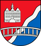
Blazon : “Lowered divided by red and blue by a slanting silver wavy bar. Above the silver facade of the Nütschau manor house, below, covering the wave beam, a continuous silver bridge. "
traffic
The place Tralau is located directly on the federal highway 21 , which cuts through the area of the municipality Travenbrück in a north-south direction.
Districts
Tralau is in the middle, Sühlen in the northeast, Schlamersdorf in the east, Nütschau in the southeast, Vinzier in the south and Neverstaven in the west. Schlamersdorf and Sühlen are east of the motorway.

Culture and sights
The list of cultural monuments in Travenbrück includes the cultural monuments entered in the list of monuments of Schleswig-Holstein.
In the Nütschau district, the 450-year-old manor house is used as a Benedictine monastery . The monastery was only founded after the Second World War under Archbishop Wilhelm Berning of Osnabrück . This was the first new founding in northern Germany since the Reformation. The St. Ansgar retreat house has belonged to the monastery since 1971.
The manor house in Tralau , which Major Alexander Jenisch had built in 1894 , is remarkable for its combination of Neo-Renaissance and Art Nouveau . The Martin Luther Church, built in 1961, is also located in Tralau .
Neverstaven was a Meierhof of the Tralau estate. Today's estate is particularly noticeable due to the wall that surrounds the 3 hectare area of the estate.
There is a large telecommunications tower near the Neverstaven district .
Personalities
The real estate agent Johann Anton Wilhelm von Carstenn was born in Neverstaven . He acquired this Meierhof in 1865 and sold it on a year later.
Web links
Individual evidence
- ↑ North Statistics Office - Population of the municipalities in Schleswig-Holstein 4th quarter 2019 (XLSX file) (update based on the 2011 census) ( help on this ).
- ↑ Schleswig-Holstein topography. Vol. 10: Timmaspe - Ziethen . 1st edition Flying-Kiwi-Verl. Junge, Flensburg 2008, ISBN 978-3-926055-92-7 , p. 38 ( dnb.de [accessed on August 6, 2020]).
- ^ Federal Statistical Office (ed.): Historical municipality directory for the Federal Republic of Germany. Name, border and key number changes in municipalities, counties and administrative districts from May 27, 1970 to December 31, 1982 . W. Kohlhammer GmbH, Stuttgart / Mainz 1983, ISBN 3-17-003263-1 , p. 187 .
- ↑ Results of the local elections on May 6, 2018. Bad Oldesloe-Land Office, May 16, 2018, accessed on October 14, 2018 .
- ↑ The end of an era. Stormarner Tageblatt, June 15, 2018, accessed on October 14, 2018 .
- ↑ Schleswig-Holstein's municipal coat of arms


