Stacking field
| coat of arms | Germany map | |
|---|---|---|

|
Coordinates: 53 ° 36 ' N , 10 ° 13' E |
|
| Basic data | ||
| State : | Schleswig-Holstein | |
| Circle : | Stormarn | |
| Office : | Siek | |
| Height : | 46 m above sea level NHN | |
| Area : | 10.12 km 2 | |
| Residents: | 1862 (Dec. 31, 2019) | |
| Population density : | 184 inhabitants per km 2 | |
| Postal code : | 22145 | |
| Area code : | 040 | |
| License plate : | OD | |
| Community key : | 01 0 62 071 | |
| LOCODE : | DE TAP | |
| Office administration address: | Hauptstrasse 49 22962 Siek |
|
| Website : | ||
| Mayor : | Jürgen Westphal (WGS) | |
| Location of the municipality of Stapelfeld in the Stormarn district | ||
Stapelfeld is a municipality in the Stormarn district in Schleswig-Holstein .
geography
Stapelfeld borders on Hamburg immediately to the east . The Stellau and the Wandse flow through the municipality.
history
The round village of Stapelfeld was probably founded around 1150. In 1527 the Danish king bought Stapelfeld. From 1782 to 1784, under the Danish government, the pinning was carried out, in which the communally used land was distributed to the farmers.
From 1867 Stapelfeld was under the Prussian government.
In 1914 a school was founded. As the successor to this school, the primary and secondary school in Stapelfeld was inaugurated in May 1966. Since 1999 there has only been the elementary school branch.
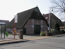
The oldest building in town is the Kratzmannsche Kate at Reinbeker Straße 4. There are different details about the construction: It is said to have been completed in 1834 or 1854. In 1992 it was restored in accordance with a listed building. Most of the meetings of the municipal council and committees, as well as cultural events, take place there today.
politics
Community representation
Of the 13 seats in the municipal council who Wählergemeinschaft WGS and the CDU since the local elections in 2018 five seats each. The SPD won three seats. Mayor is Jürgen Westphal (WGS).
Stapelfeld - like Braak , Brunsbek , Hoisdorf and Siek - is administered by the Siek Office .
coat of arms
Blazon : "A broad silver bar in red, topped with a two-axle, tillerless blue covered wagon with wide wheel rims."
education
Stapelfeld has a primary school, there are two classes per year (as of 2018). The Stapelfeld elementary school is attended by children from Stapelfeld, Braak and Brunsbek, among others. In 2018 it was decided to build a new elementary school.
The place has a daycare center that accepts children from Stapelfeld and Braak (as of 2018). There is also a childminder.
Culture
The Stapelfelder Kulturkreis e. V. was founded in 1991 and regularly offers music evenings, art exhibitions, cabaret, readings, theater for children and Low German evenings. The events usually take place in the Kratzmannschen Kate at Reinbeker Straße 4.
Sports
In Stapelfeld there is an artificial turf soccer field with a running track, an archery facility, a tennis court, a sports hall and riding stables.
Economy and Infrastructure
Companies
The 110 meter high chimney of the Stapelfeld waste incineration plant can be seen from afar .
In Stapelfeld there is a supermarket for everyday needs. There are also several farmers who u. a. Sell milk, eggs and meat. There is a gas station in the main street.
traffic
Stapelfeld is on the Hamburg Transport Association served by the Hamburg public transport system. The federal highway 1 runs and the federal road 435 ran through the municipality.
Web links
Individual evidence
- ↑ North Statistics Office - Population of the municipalities in Schleswig-Holstein 4th quarter 2019 (XLSX file) (update based on the 2011 census) ( help on this ).
- ^ Municipality of Stapelfeld 2018. Amt Siek, May 6, 2018, accessed on October 14, 2018 .
- ↑ Schleswig-Holstein's municipal coat of arms


