
Hamburg-Bramfeld
 district of Hamburg |
|
|---|---|
  |
|
| Coordinates | 53 ° 36 '31 " N , 10 ° 4' 21" E |
| surface | 10.1 km² |
| Residents | 52,748 (Dec 31, 2019) |
| Population density | 5223 inhabitants / km² |
| prefix | 040 |
| district | Wandsbek |
| Source: Statistical Office for Hamburg and Schleswig-Holstein | |
Bramfeld is a district of Hamburg in the Wandsbek district . The district has about 50,000 inhabitants. The former village of Hellbrook also belongs to Bramfeld . The former village of Bramfeld only became part of Hamburg in 1937. The whole area is a less prominent conurbation of residential and commercial settlements, something that is described today with the term Zwischenstadt . This is village terrain that has been enclosed by a growing city and currently has both urban and village elements.
geography

Geographical location
Bramfeld is located in the northeast of Hamburg on both sides of the former B 434 , which in this section is called Bramfelder Chaussee , and with almost 50,000 inhabitants is one of the most populous districts of the Hanseatic city.
The following districts border on Bramfeld: Wellingsbüttel and Sasel in the north, Farmsen-Berne in the east, Wandsbek (all administrative districts of Wandsbek) and Barmbek-Nord in the south, and Steilshoop (Wandsbek administrative district) and Ohlsdorf (Hamburg-Nord administrative district) in the west .
On the edge of Bramfeld, already in Steilshoop, lies the Bramfelder See . The Seebek and Osterbek flow on the edge of the district, with the Seebek, which was formerly also called Grenzbach (see: Grenzbachstraße ), forms the border to Barmbek-Nord or Steilshoop for most of its course, while the Osterbek forms the boundary in many places to Wandsbek and Farmsen-Berne.
history

The first documented mention of Bramfeld comes from the year 1271. This means that the town came into being in the time of eastern colonization, when Henry the Lion pushed back the Slavs, re-founded the city of Lübeck , and the Hanseatic League created an economic boom in the Hamburg area . The place name Bramfeld refers with its first syllable to the yellow flowering gorse bush - old German Bra (a) mbusch - which was typical of the heather and moor landscape of the area. This plant can also be seen in the Bramfeld coat of arms. The ending field indicates that the village is situated in a forest-free area, the Bramfelder Heide .
In the 15th century, ten Hufner lived in the farming village of Bramfeld, they were farmers who owned so much land that they could support a family on it. They tilled the fields together. There was a farmer's bailiff who administered the place and who was granted various privileges. He had the right to brew, to distill and to run a pub. He was also entitled to the fishing rights on the Bramfelder See. The customs office was also in his yard.
At that time the farming villages were often pledged by their sovereigns to monasteries, aristocrats or merchants and had to pay taxes to both the sovereign and the pledgee. The rulers of Bramfeld were the Counts of Holstein, who left the village to changing financiers.
In the 15th century, the city of Hamburg had the opportunity to expand its territory and to take permanent possession of some localities in the north and east. In the 16th century, when the ownership of many monasteries was dissolved during the Reformation, Hamburg was able to expand its sphere of influence once again and include well-known later parts of the city such as Eppendorf or Barmbek in its area. The opportunity to acquire further areas in the surrounding area in the 17th century allowed the Hanseatic city to pass by. So Bramfeld stayed in Holstein and gradually developed into an artisan and farming village outside the gates of Hamburg. For a long time, Bramfeld was an important vegetable supplier for Hamburg. The farmers of the place had an additional income from the haulage business, because an important trade route from Hamburg to Lübeck led through Bramfeld .
In 1663, Stormarn's first fire guild was founded in Bramfeld .
In the 18th century came the great land reform. The lands of the communities were measured and assigned to the individual farmers as private property. That led to economic growth. Until then, the farming families had largely lived on their own, but now new occupations have emerged in the village. Blacksmiths, shepherds, wheel makers, shoemakers and tailors were the first in Bramfeld, followed in the 19th century by carpenters, bakers, butchers, painters, bricklayers and many others. The village grew. New buildings were added to the ten courtyards that were along the village street and around the village square. The development of the main road extended far to the south and north. New streets were laid out parallel and across the old village center. The customs office was moved to Hellbrook, the southern part of Bramfeld, directly on the border to Hamburg-Barmbek.
With the prospect of good business, many farmers parceled their land and sold it. For example to the city of Hamburg, which wanted to expand the Ohlsdorf cemetery in 1913, to individuals willing to build, to businesses and, above all, to gardeners. In 1866 the first gardener settled in Bramfeld. Dozens of people should follow him. After the First World War, Bramfeld was the largest vegetable growing area in Germany after the Vier- und Marschlanden. The cabbage and rhubarb fields, which stretched on both sides of the Bramfelder Chaussee from the Barmbeker border to the center of the village near the Easter church, were Bramfeld's trademark for several decades.
Growing to Hamburg

When Hamburg was enclosed by Prussian territory in the 19th century, the Prussian cities of Altona, Wandsbek and Harburg, which were located close to the free city of Hamburg, created strong competition for dominance in the Lower Elbe region. The small Bramfeld was in between and had belonged to the Prussian Schleswig-Holstein, which belonged to the Stormarn district, since 1867. Before that, the village belonged to the Duchy of Holstein-Gottorp and was almost always under Danish administration from 1460 to 1864. The official seat was Trittau, from 1889 to 1910 Poppenbüttel, from 1910 there was its own district Bramfeld (to which Steilshoop was administratively part).
About the same distance from Hamburg and Wandsbek, the Bramfelder wanted to be incorporated into Hamburg, especially since Farmsen, which borders Bramfeld in the east, also belonged to Hamburg. But Prussia did not allow that. At the beginning of the 20th century the situation became increasingly untenable. With its border, Hamburg had grown directly into the Bramfeld area. Bramfeld was drawn into the development of the metropolitan area. Its population grew by leaps and bounds, as did the costs of the community treasury. Tasks of urban development, local transport planning and the installation of a sewer system and drinking water supply were on the agenda, but could not be solved in the confusion of competencies and the different political interests between Prussia and the Free and Hanseatic City. Hamburg expanded the sewer system, U- and S-Bahn lines, which Bramfeld did not include. To this day, Bramfeld lacks the often promised underground or S-Bahn connection. Bramfeld was only fully connected to the central sewer system and drinking water supply after the Second World War. Although the Bramfeld tram connection was largely prepared in 1914, this connection (with line 9) was not built until 1948.
In 1937 Hamburg prevailed in the struggle for supremacy in the Lower Elbe region: As part of the Greater Hamburg Act , Bramfeld and Steilshoop came to Hamburg. After the war, Bramfeld was finally included in central Hamburg city planning. This benefit was paid dearly. Bramfeld lost its own face, the cultural institutions - cinemas, restaurants, dance halls and stages - experienced a decline in favor of the facilities in the center of Hamburg. The nurseries made room for housing estates, the village pond was filled in, the thatched roof houses demolished to make room for larger new buildings, and the Bramfelder Chaussee was expanded to four lanes. The traffic increased rapidly. From 1949 to 2007, Bramfeld had its own local office, which was also responsible for the Steilshoop district.
Since the 1980s, people have been thinking about how to make Bramfeld more attractive and how to emphasize its center. It is clear that Bramfeld will remain an in-between town, with all the advantages and disadvantages that go with it. The main disadvantages are the noisy thoroughfare and various urban development grievances. The advantages include the greenery, the housing estates with their different living qualities and the good infrastructure in the schools and kindergartens.
Bramfeld in the time of National Socialism
As part of the Hamburg uprising of the KPD , the police station was attacked on October 23, 1923 and the weapons lying there were captured. With the Greater Hamburg Law of 1937, Bramfeld came to Hamburg and was added to the Wandsbek district with the formation of the administrative districts .
In March 1933, SA and NSDAP members took power in Bramfeld, although the SPD and KPD had a majority of two thirds of the votes. The National Socialists appointed the 32-year-old agricultural scientist Joachim Caesar as mayor, who was a NSDAP Gauredner in Schleswig-Holstein and later made a career in the SS (most recently he was Obersturmbannführer in Auschwitz ). On August 19, 1933, the so-called Propaganda March of the National Socialists took place through Bramfeld, to which SPD and KPD members were forced to run the gauntlet . A contingent of 100–200 SS, SA and NSDAP members had fetched around 20–30 Social Democrats and Communists from their apartments, put them in their hands with signs saying “We communists are pigs” and “We are learning order” forced them to come along. They had to distribute Nazi propaganda papers and were forced to sing along with National Socialist songs. If they didn't sing or shout “Heil Hitler” loudly enough, they were beaten and kicked by the National Socialists, so that some of the abused collapsed. The march led along today's Bramfelder Chaussee, to Hildeboldtweg, via Mützendorpsteed, Herthastraße and again the Bramfelder Chaussee to Owiesenstraße, Fabriciusstraße, Bauernrosenweg and back to the Klempau inn opposite the Easter church. There the local group leader of the NSDAP, Emil Kaiser, gave a speech in which, according to reports from eyewitnesses, he is said to have said that the coercive participants still got away with a black eye today, but that they could have been killed.
Holocaust Remembrance Day 2001
On the Holocaust Remembrance Day on January 27, 2001, Bramfelder remembered the atrocities of the Nazis in Bramfeld and demonstrated against xenophobia and intolerance on the "historic route". The Bramfeld district conference and the Steilshoop coordination conference together with the Bramfeld churches, schools, the political parties, the VVN and many others called for this demonstration. The fact that the neo-Nazi Christian Worch and his supporters were planning a march through Bramfeld for the same day aroused outrage and protests among the citizens. After the ban and another submission by Worch, the Hamburg Administrative Court ruled that it was postponed to the following day. The demonstration on the historic route, in which more than 1500 Bramfelder and Steilshooper took part, ended with a final rally on the market square on Herthastraße. During the neo-Nazi march on the following day there were loud protests and the bells rang at the Easter Church, so that the police ordered the early termination of this march near the village square.
Chronological outline
- Around 1100
- Founding as Stormarnsches village in the context of colonization by Heinrich the Lion / Christianization and expulsion of the Slavs were preceded / There were 10 farm positions, a farmer governor, the village ran in Allmende (joint cultivation of the fields)
- 1271
- First documented mention as a village subject to taxes to the Hamburg cathedral chapter / taxes in the form of natural products and services
- 1460-1863
- Mainly under Danish administration / The village communities of Klein-Bramfeld, Haldesdorf and Rokesberg near Bramfeld were devastated by wars and epidemics / After the end of the Thirty Years' War, the Bramfeld farmers increased the number of their fields from 7 (1708) to 12 (1750)
- 1772
- Coupling and replacement of the common land economy / 251 inhabitants / In addition to the 10 farming families, craftsmen and day laborers were also among the villagers / The possibility of selling land created many smaller farms
- 1848-1864
- National questions and the demands for a parliament shook the region / Schleswig-Holstein conflict ended with the victory of Prussia-Austria over Denmark
- 1867
- Bramfeld came under Prussian administration and together with Poppenbüttel formed an administrative district within the Stormarn district with a district office in Wandsbek / The agricultural areas were divided up further / The first gardeners settled in Bramfeld
- 1900
- 1506 inhabitants / The village has become a suburb / The district of Hellbrook grew closer to Barmbek / More gardening businesses than farms in Bramfeld
- 1910
- 3429 inhabitants / Bramfeld together with Steilshoop formed a separate administrative district / tasks such as the conception of local transport and urban development had to be solved by the municipality
- 1919
- The Hochbahn is planning an underground connection for Bramfeld for the first time (discarded in the early 1920s)
- 1928
- 7171 inhabitants / Bramfeld has become a residential area for workers and employees / Settlement construction began / Bramfeld was the second largest vegetable growing area after the Vier- und Marschlanden / Desolate state of the municipal finances / Tasks such as sewerage, trade supervision, traffic development and land use planning overwhelmed the municipal administration and could not deal with the larger neighbors Wandsbek and Hamburg
- 1937
- In the course of the Greater Hamburg Law, Bramfeld was incorporated into Hamburg / Since Bramfeld had been a "red" district since 1918, when the Nazis came to power in 1933, there were excesses against Social Democrats and Communists / 1941-1944 the Maimoorsiedlung was under the leadership of the " New home ”built with Dutch forced laborers
- 1948
- Bramfeld receives tram connection, line 9: (Airport) -Hauptbahnhof-Barmbek-Bramfeld
- 1949
- As part of the district administration reform, Bramfeld came to the district of Wandsbek and formed a local office area with Steilshoop / 24,418 inhabitants 1950 / Further settlement construction such as the garden city Hohnerkamp (1953) and the Hegholt settlement (1960)
- 1959
- The Otto-Versand came to Bramfeld and soon became the largest employer in the district / Max Bahr's long-established craft business (in Bramfeld since 1879) developed into one of the largest hardware stores in Germany / Bramfeld changed from a workers' to a salaried district
- 1965
- 56,663 residents / The elevated railway closes the tram route between the main station and Bramfeld
- 1967
- The village character with thatched roof houses and the village pond finally disappeared with the new Karstadt building / expansion of the Bramfelder Chaussee cut up the district
- 1980
- Rethinking of urban development began / The loss of the town center was regretted, the increase in traffic was criticized, alternative planning was commissioned
- 1992
- Establishment of the "Round Table for Bramfeld" on the occasion of the planning of the pavilion village for asylum seekers / refugees
- 1993
- Foundation of the district conference
- 1996-1999
- Completion of a private eco-settlement and a solar model settlement of the HGW on Karlshöhe / 50 038 inhabitants (1998)
- 2002
- Presentation of the master plan concept for the future of the Bramfeld town center, which has emerged from three planning workshops
- 2003
- Brakula and ancillary buildings are placed under monument protection on the initiative of the city district archive
- 2006
- GbR Kulturinsel Bramfeld founded to tackle the concrete implementation of the Kulturinsel project
population
The Bramfeld population is composed as follows (data from the North Statistics Office, as of December 2016):
- Total population: 51,858
- Minor quota: 14.5%, slightly below the Hamburg average of 16.2%.
- Share of households with children: 16.4%, slightly below the Hamburg average of 17.8%.
- Old age quota (65-year-olds and older): 21.8%, is above the Hamburg average of 18.3%.
- Proportion of foreigners: 11.4%, is well below the Hamburg average of 16.7%.
- Share of benefit recipients according to SGBII (Hartz IV): 10.3%, corresponds exactly to the Hamburg average of 10.3%
- Unemployment rate: 5.3%, corresponds exactly to the Hamburg average of 5.3%.
The average annual income per taxpayer in Bramfeld was around 30,928 euros in 2013 and is lower than the Hamburg average (39,054 euros).
Population development
- 1935: 10.173
- 2000: 50.426
- 2005: 49.985
- 2010: 50,510
- 2015: 51,115
politics
For the election to Hamburg citizenship , Bramfeld belongs to the constituency of Bramfeld-Farmsen-Berne . The 2015 state election led to the following result:
- SPD 54.5% (-0.5)
- CDU 13.7% (−6.6)
- AfD 7.9% (+7.9)
- Green 7.5% (-0.5)
- Left 6.9% (−1.4)
- FDP 5.7% (+ 0.3)
- Remaining 3.8% (–2.3)
Culture and sights

Easter Church
The church was built in 1913/1914 according to plans by Wilhelm Voigt . Externally assigned to the architectural homeland security movement, the internal structure and design as a central building corresponds to the reform movement of Lutheran church building at the turn of the century. The design models were church buildings from the 18th century in Rellingen and Niendorf . The pastorate was created in 1908 by CW Gundlach.
Old school building
The school house was built between 1888 and 1889 as a replacement for the old school house .
Brakula
The district culture center Bramfelder Kulturladen, Brakula for short, is located in a farmhouse built in 1887.
Local government
As a building for the municipal administration, the “Town Hall” was built from 1911 to 1912 according to plans by Peter Claussen.
Hohnerkamp settlement
The settlement with 1530 apartments was built between 1953 and 1954 according to plans by Hans Bernhard Reichow . It is embedded in a spacious green and garden area.
When there was a considerable need for renovation in the 1980s, the housing association SAGA decided that demolition and subsequent new construction would be more profitable. This provoked considerable public protest and squatting. The facades of the buildings have been under monument protection since 1987 . In 2004 around 150 people had lived in their settlement since the days of their first occupation.
"... for the first time an uncompromisingly south-west oriented residential construction, for the first time a consistent separation of pedestrian and bicycle traffic from car traffic and finally (almost) for the first time the attempt at social mix through the combination of different building types, such as two-storey terraced houses, three-storey rows of rental apartments and six-storey 'point houses' in diverse groupings.
The Hohnerkamp acquired its unmistakable shape through the special handwriting of its architect, Hans Bernhard Reichow, with his ideas of an 'organic' urban architecture that resolutely rejected all rationally derived squareness and thus left us with a fascinating example of flowing and curved space. "
Buildings

Hohnerkamp terraced houses in the original pastel colors of the 1950s.

On the Chaussee:
Today's Brakula, culture instead of agriculture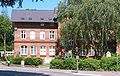
Village square:
old school building
Village square:
"Town Hall", today an inn


Economy and Infrastructure

Established businesses
The Otto-Versand has its headquarters in Bramfeld. The DIY chain Max Bahr operated until the bankruptcy in the district of one of their biggest hardware stores, that of Bauhaus was taken over and had (which according to earlier in the Bramfelder Chaussee headquartered Wandsbek was moved). It emerged from a traditional carpenter's business (proven in the village since the 18th century). The main branch was opened in 1879.
The Spiel + Hobby Haus Hartfelder was located on the village square for over 25 years. The “attraction” of this shop was an electrically operated train, which was started by a hand sensor on the glass pane of the shop window.
Vattenfall Europe (formerly HEW ) AG maintained a large depot in Bramfeld (vehicle fleet, metering, etc.) and a training center. The mains Hamburg has its headquarters at the Bramfelder Chaussee.
In addition, Max Schmeling GmbH operates a Coca-Cola bottling and sales facility for northern Germany on Wandsbeker Strasse . The music group Scooter had their production studio in Bramfeld village square above a pastry shop. Scooter front man HP Baxxter lived in Bramfeld for most of his life.

OTTO administration

MAX BAHR


traffic
The most important traffic axis is the multi-lane Bramfelder Chaussee ( B 434 ), which completely traverses the district from south to north. Despite its large population, large parts of Bramfeld are only connected to public transport by bus lines. Only on the extreme southern edge of the district are some settlements within walking distance of some of the stops of the subway, which runs just beyond the district boundary.
A tram ( line 9 ) that had existed since 1948 was discontinued in 1965. There were several plans to open up the area with a light rail . The plans were discontinued in each case. In 2014, the Hamburg Senate prefers the construction of an underground line U5 from Sengelmannstraße underground station via Steilshoop to Bramfelder Dorfplatz by the end of the 2020s. The underground station for this is expected to be built under the Bramfeld village square.
Public facilities
The public institutions there are the Bramfeld Citizens' Registration Office, a guard of the volunteer fire brigade and the police station 36. There are also many schools there ( Johannes-Brahms-Gymnasium (renamed from Gymnasium Bramfeld), Gymnasium Grootmoor, Gymnasium Osterbek, district school Bramfeld, Eenstock etc. .). The indoor swimming pool Bramfeld is located on Fabriciusstrasse. This narrowly escaped closure in the course of the bathing area renovation in 2005, against which citizens protested strongly beforehand.
Personalities
- Fritz Kahl (1859–1942), trade unionist and politician
- Werner Pinzner (1947-1986), murderer, as St. Pauli Killer became known
See also
- List of streets in Hamburg-Bramfeld
- List of cultural monuments in Hamburg-Bramfeld
- List of stumbling blocks in Hamburg-Bramfeld
literature
- Siegfried Seeler , Ingrid Seeler : Bramfeld, Hellbrook, Steilshoop. From the village to the district. Hamburg 1988.
- Uwe Schubert: Bramfeld / Steilshoop in transition. In old and new pictures. Medien-Verlag Schubert, Hamburg 1989, ISBN 3-9802319-0-9 .
Web links
- Bramfeld district archive
- Presentation of the district on the website of the City of Hamburg
- District statistics (PDF; 3.4 MB) of all Hamburg districts (as of 2010)
Individual evidence
- ^ Horst Beckershaus: The names of the Hamburg districts. Where do they come from and what they mean. Hamburg 2002, ISBN 3-434-52545-9 , p. 27.
- ↑ AKENS Information 39, Omland: "All of us 'yes' to the leader". Retrieved November 26, 2019 .
- ↑ Statistics Office North, Hamburg District Profiles, reporting year 2016, pages 146–147; Data status December 31, 2016 (accessed February 8, 2018)
- ↑ Data from 2000-2015 from the North Statistics Office, databases population Hamburg / districts
- ↑ http://www.wahlen-hamburg.de/wahlen.php?site=left/gebiete&wahltyp=3#index.php?site=right/result&wahl=973&beispiel=4&gebiet=16&idx=0&typ=4&stimme=2&hoch=0&partei=&untertyp = 23 & flip = 1 & seat = 0 & seat high = 0 & mode = list
- ↑ New underground line for Hamburg. City of Hamburg, accessed on December 14, 2017 .
Bergstedt | Bramfeld | Duvenstedt | Eilbek | Farmsen-Berne | Hummelsbüttel | Jenfeld | Lemsahl-Mellingstedt | Marienthal | Poppenbüttel | Rahlstedt | Sasel | Steilshoop | Tonndorf | Volksdorf | Wandsbek | Wellingsbüttel | Wohldorf-Ohlstedt