
Osterbek
| Osterbek | ||
 Inner-city canals of Hamburg |
||
| Data | ||
| Water code | DE : 595674 | |
| location | Hamburg ( Wandsbek and Nord districts ), Germany | |
| River system | Elbe | |
| Drain over | Alster → Elbe → North Sea | |
| source | in Farmsen-Berne 53 ° 37 ′ 17 ″ N , 10 ° 6 ′ 43 ″ E |
|
| muzzle | as a long train to the Outer Alster Coordinates: 53 ° 34 ′ 35 ″ N , 10 ° 0 ′ 21 ″ E 53 ° 34 ′ 35 ″ N , 10 ° 0 ′ 21 ″ E
|
|
| Right tributaries | Seebek | |
| Navigable | the Osterbek Canal | |
 Renatured section of the Osterbek on the Berberweg |
||
The Osterbek is a brook in Hamburg . It rises in Farmsen-Berne near the “Wegelstück” road and flows into the Outer Alster as the “Langer Zug” .
The upper reaches of the Osterbek have largely been straightened today. The section between the tournament climb and the Berberweg was renatured in 2003 as a compensation measure for environmental damage caused by building projects in other places.
At the tunnel ramp of the subway in front of the Wandsbek-Gartenstadt station, the Osterbek is directed through a culvert .
The Seebek flows into the Osterbek near the shipbuilding research institute , coming from the Bramfelder See .
From the Wachtelstraße, the Osterbek is developed as the Osterbek Canal . The canal was built step by step from 1863 to 1912 and at that time attracted important industrial settlements. Examples are the rubber factory , on the premises of which the Museum of Labor is now located, and the Kampnagel factory. The electrical works on Flotowstrasse, the neighboring gas works (today " Alster-City ") and the waste incineration plant on the Dulsberg are no longer available .
The earth masses produced during the construction of the canal were used to build the embankments of the light rail , the elevated railway and the freight bypass .
In the upper part of the canal, a branch leads over the Barmbeker branch canal to the Stadtparksee , which in turn is connected to the Outer Alster through the Goldbek Canal . This canal was built to supply the underground's own power station with coal. Since 1912, is situated on Osterbekkanal the Alster Shipyard , today in the Alster ships are maintained and repaired. Until 1984 there was a regular service within the HVV (line 52: "blue flag") with piers at Mühlenkamp , Bachstrasse and Saarlandstrasse . Before the Second World War , barges served as connecting services from the larger steamers between Mühlenkamp and the Stadtparksee. From the 1930s onwards, industrial companies began to migrate due to the lack of opportunities to expand the factory premises and structural changes; they were replaced by the spreading residential area.
history
The Osterbek used to be called Bernebeke (narrow brook) and gave the district of Barmbek its name. In 1571 there was a battle between Winterhude and Barmbek over the Winterhude common pasture on the Osterbek .
As part of a feasibility study, the North District Office is planning a further renaturation measure by creating a natural course of the Osterbek river at the level of Lämmersieth to Wachtelstrasse. In addition, cycling and hiking trails are planned on the banks of the Osterbek.
Motorway planning in the post-war period
The Hamburg development plan from the 1950s envisaged the construction of a city motorway ("Osttangente") on a section of the Osterbek Canal, between the Barmbeker branch canal and the crossing of the S-Bahn. The watercourse should be piped in order to provide the necessary areas for the expressway.
Another city motorway, the so-called “Walddörferlinie”, was to be built from Krausestrasse towards Bramfeld in the area of the stream.
Fish fauna
The dominant fish species in the one to two meter deep Osterbek Canal include roach , bream , perch and in some places pike under jetties or weathered river banks. Eels find ideal living conditions on the muddy canal floor and in the holes in the bank walls. Carp and tench are also found especially on the Lange Zug and in the pond rose fields , especially where walkers feed water birds with bread. Smaller swarms of alandas and consuming asp can be observed on the water surface, especially in the summer months.
this and that
- The " Fleetenkieker " have their quarters at the pontoon opposite the campaign nail factory.
- Osterbek is the namesake of the Osterbek grammar school in Hamburg-Bramfeld.

Osterbek Canal on the Long Zug

Mühlenkampbrücke

Bachstrasse Bridge

ATG shipyard
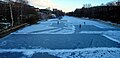
Osterbek Canal in winter

Between Adlerstrasse and Augustenburger Ufer


Web links
Individual evidence
- ↑ Name change, presumably due to a change in the course of the river when the copper mill was established, see http://www.hamburg.de/Behoerden/Umweltbehoerde/foej/wandse/berner.htm
- ↑ “ Fear about the Osterbek Canal ” Hamburger Morgenpost No. 193/33 Friday, August 20, 2010, p. 16
- ^ Barmbek-Nord 26 development plan from May 1968. Archived from the original on November 9, 2014 ; Retrieved November 9, 2014 .
- ↑ http://www.fischundfang.de/Wo-faengt-man/Top-Gewaesser-Deutschland/Hamburg-Der-Osterbek-Kanal
- ↑ Udo Schroeter: The fishing guide Hamburg - Free waters. The best 150 fishing spots in town, published by Die Rapsbande, Fehmarn, 2005, pp. 26–33, ISBN 978-3937868110