
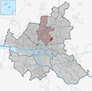
Hamburg-Dulsberg
|
district of Hamburg |
|
|---|---|
  |
|
| Coordinates | 53 ° 34 '54 " N , 10 ° 3' 48" E |
| surface | 1.2 km² |
| Residents | 17,229 (Dec. 31, 2019) |
| Population density | 14,358 inhabitants / km² |
| Post Code | 22049, 22081 |
| prefix | 040 |
| district | Hamburg North |
| Transport links | |
| Subway |
|
| Train |
|
| bus | Metro buses 23 and 28, city buses 171 and 271, night bus 600, express bus 36 |
| Source: Statistical Office for Hamburg and Schleswig-Holstein | |
Dulsberg ( Low German : Dulsbarg ) is a district in the Hamburg-Nord district of the Free and Hanseatic City of Hamburg . In terms of area, Dulsberg is one of the smallest districts of Hamburg. Until 1951 it formed the district of Barmbek together with Barmbek-Nord and Barmbek-Süd .
geography
Dulsberg is located in the east of the inner city of Hamburg, which is characterized by a dense urban structure with central functions. The population density of 14,500 inhabitants per square kilometer is very high compared to the Hamburg districts, it is roughly on par with Ottensen (12,500 inhabitants / km²) or Sternschanze (15,500). Dulsberg is demarcated from the neighboring districts: to Barmbek-Süd through the course of the S-Bahn line, to Barmbek-Nord through the Osterbek and to Wandsbek through the Wartenburger Weg, Kiefhörn, the Eulenkamp and the Stormarner Strasse. In the extreme southwest, at the Friedrichsberg S-Bahn station, Dulsberg shares a border with Eilbek a few meters long .
While the boundaries to the two districts of Barmbek were defined with the division of the old district of Barmbek in 1951, the Kiefhörn was agreed as the boundary to the village of Hinschenfelde as early as 1365 in a comparison of the respective landlords (see also section history).
Green areas and squares
The “Grünzug Dulsberg”, an approximately 50-meter-wide park designed as a park, runs through the center of the district. Another green area is located in the north of the district on both sides of the Osterbek. Immediately behind the south-western boundary of the district is the Friedrichsberger Park in Barmbek-Süd . Many Dulsberg residential complexes also have green areas in the inner courtyards.
There are several allotment parcels along the S-Bahn and on the Osterbek.
The central square of the district is Straßburger Platz. There is also Elsässer Platz at the intersection of Eulenkamp and Elsässer Straße. Once used as a marketplace, today it is mainly used as a parking lot for cars.
history

The name can be traced back to a hill that was called Tollsberg (Teufelsberg or Zollberg) and was roughly in the area where Krausestraße and Lauenburger Straße intersect today. Dulsberger districts were first mentioned in a document in 1365, the border disputes between the owners of Barmbeks, the Hospital of the Holy Spirit , and the owners of Hinschenfeldes , the brothers Henneke and Emeke von Strutz, were settled in a comparison, according to which, among other things, the wood "Kyfhorn" (there , where the street Kiefhörn is today) "scholen stayed forever by the Dorpe Barnebeke and by the Huse des hilligen Geist tho Hamborch". For centuries the Dulsberg remained arable land of the Barmbeck farmers, from the beginning of the 20th century the city of Hamburg included it in the plans for city expansion. With the construction of the light rail to Hamburg-Ohlsdorf , the Osterbek was canalized, as the earth was also used to build the railway embankments. In 1910 the first industry was established here on the later border with Barmbek-Nord. At the southwestern tip of the Dulsberg, the Friedrichsberg station was opened on December 5, 1906 to connect the Friedrichsberg State Hospital . This is also where the area's first residential construction was built in Dithmarscher Strasse and Stormarner Strasse, on the border with Wandsbek, which was still Prussian territory at the time .
A plan was drawn up for further settlement. Due to the First World War, however, it was not carried out. The planning was only taken up again in the 1920s by the building director Fritz Schumacher . Instead of single-storey plastered buildings, three- and four-storey clinker buildings were built. After the end of inflation , construction began, which was canceled in 1931 due to the Great Depression.
With effect from May 11, 1951, the district administration in the Free and Hanseatic City of Hamburg (1949) split up the then Barmbeck-Südost district and the Dulsberg district emerged.
Industry
In 1910, Hamburg's second waste incineration plant went into operation on the Osterbek Canal . However, she hired him again in 1939, partly because of the extreme odor nuisance. After the destruction in World War II, the plant was not put back into operation. The two 50-meter-high chimneys remained in place until the 1960s, as demolition seemed impossible because of the surrounding residential buildings. For the targeted collapse of the remains, a notch was then carved into the masonry. After the demolition, many businesses were settled on the site.
Another industrial enterprise on the Dulsberg was the neighboring fish canning factory "Walckhoff", which also started operations in 1910. The company existed until 1972.
Religions

There are two Evangelical Lutheran churches on the Dulsberg . While the Frohbotschaftskirche was already planned for when the district was built and built in the mid-1930s, the Dietrich Bonhoeffer Church was added in the 1960s. At the time, the congregation, with 13,500 believers and four pastors, was the largest in the former Hamburg regional church. It was therefore decided to divide the community. At the end of the 1990s, the two congregations merged again due to the decline in church membership. The congregation has not used the Bonhoeffer Church since 2005. After various temporary uses - among other things, church services were held there by the Catholic-Apostolic Congregation , while the church was being renovated - the church has been rented to the Chinese-Christian community in Hamburg since September 2015.
statistics
- Minor quota: 12.4% [Hamburg average: 16.3% (2017)].
- Elderly rate: 12.6% [Hamburg average: 18.2% (2017)].
- Proportion of foreigners: 21.6% [Hamburg average: 17.1% (2017)].
- Unemployment rate: 8.5% [Hamburg average: 5.2% (2017)].
The average income per taxpayer in Dulsberg is 21,239 euros annually (2013), the Hamburg average is 39,054 euros.
Buildings

Today's Dulsberg was designed in the late 1920s by the chief building director Fritz Schumacher as a new housing estate on a larger scale than the Jarrestadt . The planning area encompassed the entire area of the district between Krausestrasse (then Ahrensburger Strasse ), the Osterbek Canal and Tondernstrasse. The planning changed a development plan from 1918/1919 fundamentally. The green spaces have been enlarged, the number of floors reduced from five to six floors to a four-story linear structure - three-story near the long green corridors. The rescheduling was made possible by the extensive city property.
Parallel to the Osterbek Canal, a green corridor divides the area from west to east.
Schumacher himself was responsible as an architect for the schools Alter Teichweg , Adlerstraße and Krausestraße . Other architects were Hans and Oskar Gerson , Karl Schneider , the brothers Paul and Hermann Frank and the architectural community Rudolf Klophaus , August Schoch and Erich zu Putlitz . The then pioneering architectural style of reform housing is still a destination for numerous domestic and foreign architects and town planners.

Eulenkamp and Stormarner Straße formed the border with the Prussian Wandsbek .
Only in the southern part of Dithmarscher Straße were there buildings from the turn of the century.
During the Second World War, Dulsberg was almost completely destroyed by Operation Gomorrah . On the Dulsberg, the “memorial in memory of the bomb victims” on the corner of Alter Teichweg / Lothringer Strasse is intended to remind of this, however, in many cases the outer walls were still preserved due to the destruction with incendiary bombs. Therefore, one rebuilt according to old plans. In the arcades built by the Frank brothers between 1927 and 1931 , only the top floors were affected, as concrete was used for the ceilings and stairwells .
politics
For the election to Hamburg citizenship , Dulsberg belongs to the constituency of Barmbek-Uhlenhorst-Dulsberg . The 2015 state election led to the following result:
- SPD : 47.5% (-4.7)
- Left : 13.7% (+2.5)
- Greens : 12.0% (+0.5)
- CDU : 9.4% (−3.5)
- AfD : 6.3% (+6.3)
- FDP : 3.6% (+0.1)
- Others: 7.5% (-1.2)
In federal elections, the district belongs to the Hamburg-Mitte constituency .
In the election for the district assembly Hamburg-Nord, Dulsberg belongs to constituency 5 "Barmbek-Süd / Dulsberg".
Sports

The Hamburg / Schleswig-Holstein Olympic Training Center is located in Dulsberg . The Dulsberg-Bad in the east of the district, which belongs to the Olympic base, is also the state performance center of the Hamburg Swimming Association. It is planned to build state performance centers for handball and judo on the same site.
The Alter Teichweg district school has been expanded to become an elite sports school due to its proximity to the Olympic base. There are currently sport-oriented classes that are equipped with members of the youth squad of the Hamburg Football Association and the Hamburg Swimming Association. Everyday school life is designed in such a way that performance-oriented training can be integrated into the daily routine. In addition, when scheduling class work and final exams, the competition dates of the students are taken into account.
With the Beach Center Hamburg, another sports facility was created on the Dulsberg on the edge of the outdoor pool in 2010. In addition to outdoor courts, there are also two halls for beach volleyball.
Economic and social structure

Dulsberg is one of the poorer districts of Hamburg. The average income per taxpayer in 2013 was € 19,453, significantly lower than the Hamburg average of around € 35,500. 17.7% of the population received Hartz IV benefits in 2016, compared with 10.3% of the entire Hamburg population. The unemployment rate in 2016 was 8.9 percent of 15 to 65 year olds. Comparatively few Dulsbergers are of retirement age: only 12.9% of the residents are 65 years or older, in all of Hamburg around 18.3 percent of the people are already that old.
Dulsberg was massively renovated and redesigned as part of a social district development program between 1995 and 2002. A partial amalgamation of small apartments created larger and more family-friendly apartments.
In the meantime, Dulsberg is also a destination for students looking for accommodation. The gastronomy scene is more down-to-earth, but the good transport links and the range of comparatively cheap apartments in a quiet and green area are tempting.
In recent years, many small retailers have had to go out of business. This is not only due to the low purchasing power, but also to the proximity to the district center of Wandsbek Markt with a highly differentiated retail offer that siphons many customers from the district. Many small retailers have had to close, especially on Dithmarscher Strasse, a 1950s-style shopping street. Some of the former shops have now been converted into apartments. Smaller shops and restaurants can now be found mainly in Dithmarscher Straße and along Straßburger Straße around Straßburger Platz, which also has a weekly market. There are three supermarkets on Alten Teichweg and in the backyards on Osterbekkanal there are also areas for small businesses and craftsmen. Further commercial areas are in the west of the district, between Krausestrasse and the S-Bahn. Apart from that, the infrastructure in Dulsberg is influenced by the location between the two closely neighboring, well-developed and quickly accessible district centers (B1 centers) in Wandsbek (Wandsbek Markt) and Barmbek ( Fuhlsbüttler Straße ).
Of the approximately 10,500 residential units in the district in 2004, a total of almost 4,900 units were owned by the municipal housing company SAGA or by cooperatives.
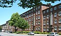
The Friedrich-Naumann -Hof on Nordschleswiger Straße

Dancing girls by Martin Irwahn in the inner courtyard of the Friedrich-Naumann-Hof (former fountain)
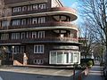
Arcade houses Oberschlesische Strasse


traffic


Dulsberg is well connected to the rapid transit network in the Hamburg transport network. The subway stations Straßburger Straße and Alter Teichweg on the U1 line and Friedrichsberg station on the S1 and S11 S-Bahn lines are in the district . The journey time to downtown Hamburg is a little less than a quarter of an hour, the underground runs every five minutes between 6 a.m. and 9 p.m. In addition, the Metrobus line 23 ( Niendorf Markt - Barmbek - Dulsberg - Wandsbek Markt - Billstedt ), the Metrobus line 28 (Lufthansa base - Alsterdorf - City Nord - Barmbek-Nord - Dulsberg - Wandsbek Markt ) and several city, express and night bus routes .
Stadtrad Hamburg has three stations in the district. Veloroute 6 of Hamburg's main cycle path network runs along the southern and eastern edge of the district on Stormarner Straße and Eulenkamp. The route connects Dulsberg along the Eilbek Canal and the Alster with the city center on the one hand and along the U1 underground line with the outer districts to Volksdorf on the other. The section in Dulsberg has been poorly developed so far (autumn 2019), the route also runs over narrow bike paths and a cobblestone street. There are plans to improve the routing of the cycle paths by converting the roads.
Nordschleswiger Straße, which has four lanes as part of Ring 2 and runs in a north-south direction, divides the quarter with its high volume of traffic. A continuous counting system on Habichtstrasse / Meisenstrasse, just behind the district boundary on Ring 2, passed an average of 48,000 vehicles per working day in 2015. These included around 2,800 heavy-duty vehicles. Krausestrasse and Straßburger Strasse are also the main streets in the district, each with around 20,000 vehicles per working day. The calculated noise exposure according to the Hamburg noise map along Ring 2 in Dulsberg averaged over 75 dBA during the daytime. At night (10 p.m. - 6 a.m.), the average noise exposure from road traffic along Nordschleswiger Strasse is over 65 dBA. In some places over 70 dBA are reached.
The Dulsbergers themselves have comparatively few cars of their own. In 2016 there were 224 private cars per 1,000 inhabitants, significantly fewer than the average for the Hamburg population (338 private cars per 1,000 inhabitants).
Traffic history

After the construction of the subway to Wandsbeker Markt cost considerably more money than planned, the plan was deviated from to run the route south of Eulenkamp over Friedrich-Ebert-Damm to Farmsen station . Instead, the shorter route to Wandsbek Gartenstadt was chosen . But it was enough for two stops. The distance between the two subway stations in Dulsberg, Alter Teichweg and Straßburger Straße, is only 550 meters, which is usually more common in the centers of large cities.
The then tram line 8 ran through Dulsberg (Dehnhaide via Straßburger Strasse and Friedrich-Ebert-Damm to the Trabrennbahn). From 1960 the tram ran as line 16 from the Trabrennbahn via Dehnhaide to Hagenbeck's zoo. Tram traffic in Dulsberg was stopped at the end of April 1963, two months after the opening of the Straßburger Straße underground station. On the median of Straßburger Strasse there is only a single, approximately seven-meter-long fragment of rail to be found today (between Elsässer Strasse and Nordschleswiger Strasse); the median now serves as a parking area. The operation of all tram lines in Hamburg was finally stopped in 1978.
Others
There are eight kindergartens, 62 handicraft businesses, 24 resident doctors, 8 dentists and three pharmacies in the district.
Further facilities are a youth house, a playhouse, and a district office .
The novel Pussykiller by the author Pavo Pejić , born in 1984, was published in 2009 and is set in the Dulsberg district, for example on Naumannplatz, on Tiroler Straße and at the intersection at the Straßburger Straße subway station . The author grew up in Dulsberg himself.
The film director Özgür Yıldırım , born in 1979, known for his feature film Chico , also comes from Dulsberg.
The punk / indie band Schrottstrich , which has been based in Hamburg since the early 2000s, describes the neighborhood's attitude towards life in the song Dulsberg , published in 2017 .
From 1990 to 2003, Dulsberg was one of the districts with the highest crime rate. Since then there has been a significant decline in the numbers, which today are even below the city-wide average in some crime groups such as violent crimes or bodily harm.
education
.5.22669.ajb.jpg)
There are two schools in Dulsberg: the Alter Teichweg elementary and district school and the upper level of the Emil Krause School on Krausestrasse.
See also
- List of streets, squares and bridges in Hamburg-Dulsberg
- List of cultural monuments in Hamburg-Dulsberg
- List of stumbling blocks in Hamburg-Dulsberg
literature
- Fritz Schumacher : Becoming a residential city. Westermann, Hamburg 1932. (Reprint: Christians, Hamburg 1984, ISBN 3-7672-0866-0 )
- History group Dulsberg eV: Dulsberg - Kiek mol - district tours pp. 131–140, Hamburg 1998, Dölling and Galitz Verlag, ISBN 3-930802-78-3
- Roger Popp: Fritz Schumacher and the Dulsberg . Dölling and Galitz 2018, ISBN 978-3-86218-110-0
- Daniela Schmitt, Joachim Schnitter, Christoph Schwarzkopf: Hundred years of the Dulsberg settlement. Fritz Schumacher's initiative for reformed living. hamburger construction booklet 24, Schaff-Verlag Hamburg 2018, ISBN 978-3-944405-38-4 .
Remarks
- ↑ Hans Dreckmann , The document from July 14, 1365 , in: Hans Dreckmann / Henny Wiepking / Walter Lüdemann: Barmbek . From village to city. A home book. Dammtor-Verlag, Hamburg 1965, page 15 f.
- ↑ "New Church Life in the Dietrich Bonhoeffer Church" at www.kirche-dulsberg.de, accessed on October 30, 2016.
- ↑ Quota of minors in the Hamburg districts in 2017
- ↑ Proportion of 65-year-olds and older in the Hamburg districts in 2017
- ↑ Proportion of foreigners in the Hamburg districts in 2017
- ↑ Unemployment rate in the Hamburg districts in 2017
- ↑ Statistical Office for Hamburg and Schleswig-Holstein (ed.): Hamburg District Profile 2017 (= NORD.regional ). Hamburg 2018 ( statistik-nord.de [PDF; 6.6 MB ; accessed on November 27, 2018]).
- ↑ Listed ensemble ( list of cultural monuments in the Hamburg district of Hamburg-Nord No. 773), also the residential buildings (No. 809,810), the Frank'sche Laubengänge (No. 802) and the Krausestrasse school (No. 1760) (today: Emil -Krause School).
- ↑ Alicia Kowalik: Fritz Schumacher: On urban development in the 1920s. In: Dorothea Roos, Friedmar Voormann (eds.): Hamburg brick and clinker buildings - shape - construction - material. KIT publishing Karlsruhe 2011, ISBN 978-3-86644-657-1 .
- ↑ List of cultural monuments in the Hamburg district of Hamburg-Nord No. 1761.
- ↑ This refers to the Amalie-Dietrich-Weg school , today Lämmersieth (built 1929-31). It is located in Barmbek-Nord , but is responsible for Dulsberg children.
- ↑ List of cultural monuments in the Hamburg district of Hamburg-Nord No. 773
- ↑ www.wahlen-hamburg.de
- ^ Statisches Amt Nord (ed.): Hamburg district profiles. Retrieved January 11, 2018
- ↑ Level values of the Office for Traffic and Roads at the FHH, Download: Archive link ( Memento of the original from July 23, 2017 in the Internet Archive ) Info: The archive link was inserted automatically and has not yet been checked. Please check the original and archive link according to the instructions and then remove this notice. on July 15, 2017
Web links
- Dulsberg on hamburg.de
- Map from 1928
- dulsberg.de - Website with links to the district office, district council and other institutions on the Dulsberg
Alsterdorf | Barmbek-North | Barmbek-Süd | Dulsberg | Eppendorf | Fuhlsbüttel | Groß Borstel | Hoheluft-Ost | Hohenfelde | Langenhorn | Ohlsdorf | Uhlenhorst | Winterhude