
Hamburg-Uhlenhorst
|
district of Hamburg |
|
|---|---|
  |
|
| Coordinates | 53 ° 34 '21 " N , 10 ° 1' 7" E |
| surface | 2.2 km² |
| Residents | 18,634 (Dec. 31, 2019) |
| Population density | 8470 inhabitants / km² |
| Post Code | 22081, 22085, 22087 |
| prefix | 040 |
| district | Hamburg North |
| Transport links | |
| Federal road |
|
| Subway |
|
| Source: Statistical Office for Hamburg and Schleswig-Holstein | |

Uhlenhorst is a district in the Hamburg-Nord district of the Free and Hanseatic City of Hamburg .
Since the name of the district originally refers to the geographical name of the place, here: Horst , or the nest of owls , you don't live in Uhlenhorst, but on the Uhlenhorst.
Geographical location
The Uhlenhorst is east of the Outer Alster between the mouths of Osterbek ( Langer Zug ) and Eilbek ( Kuhmühlenteich , Mundsburg Canal ). It borders on the districts of Winterhude (north), Barmbek-Süd (northeast), Eilbek (southeast) and Hohenfelde (south). The southern boundary of the district is formed by the Eilbek Canal , which flows into the Kuhmühlenteich and finally over the Mundsburg Canal into the Outer Alster. In the north, the Uhlenhorst extends to the Osterbek Canal, which flows into the Outer Alster as the Langer Zug . The streets Herderstrasse / Winterhuder Weg , Oberaltenallee and Richardstrasse are the eastern border of the district . In the south of the district, between the St. Gertrud Church and the Kuhmühlenteich , the geographical center of the city of Hamburg is to be.
history


Surname
The place was first mentioned in a document in 1256 as Papenhude . This name goes back to the use of the meadows here by the clergy and was used for the area between the Osterbek , Eilbek , Alster and Barmbek rivers. It was a landing site for barges on the Alster. The name Uhlenhorst came up around 1608 and possibly referred to an abandoned homestead on the Alster near today's Marienterrasse, where owls lived. The Hamburg local researcher Gustav Bolland interpreted the name as a designation of an inhospitable and remote place where only owls can feel comfortable.
use
The area of today's district was originally predominantly a hardly usable swampy meadow landscape. In the 16th and 17th centuries, grazing rights in the area were often the cause of disputes between the City Council of Hamburg and the College of the Elderly , which advocated the corresponding rights of the Barmbeck farmers and the Hospital of the Holy Spirit . Until 1830 the area belonged to the land rulership of Hamm and Horn , then to the land rulership of the Geestlande . In 1837 the entrepreneurs August Abendroth , Carl Heine and Adolph Jencquel bought the area and began the planned development and parceling out. The Hofweg Canal , the Uhlenhorster Canal and the first section of the Osterbek Canal were created for drainage . In some cases, the area had to be filled up before it could be built on.
In 1892, on the initiative of Carl August von der Meden , the first international tennis championships in Germany were held on the grounds of the ice rink club on the Uhlenhorst . These championships are now taking place at the Rothenbaum in Hamburg .
district
In 1874 the Uhlenhorst was elevated to a suburb and in 1894 it was finally incorporated into Hamburg as a district. Due to the Greater Hamburg Act and the associated reorganization of the city districts, Uhlenhorst had to cede the area east of Winterhuder Weg with the Mundsburg to Barmbek-Süd in 1938 .
Before the Second World War , the Uhlenhorster Fährhaus was a popular destination. It was not rebuilt after the destruction.
statistics
- Minor quota: 12.6% [Hamburg average: 16.3% (2017)].
- Old age quota: 19.4% [Hamburg average: 18.2% (2017)].
- Proportion of foreigners: 10.8% [Hamburg average: 17.1% (2017)].
- Unemployment rate: 2.7% [Hamburg average: 5.2% (2017)].
The average income per taxpayer in Uhlenhorst is 62,479 euros annually (2013), the Hamburg average is 39,054 euros.
politics
For the election to Hamburg citizenship , Uhlenhorst belongs to the constituency of Barmbek-Uhlenhorst-Dulsberg .
Election results
| Citizenship election | SPD | CDU | Green 1) | FDP | Left 2) | AfD | Rest |
|---|---|---|---|---|---|---|---|
| 2015 | 39.9% | 19.1% | 14.7% | 12.4% | 5.8% | 4.6% | 3.5% |
| 2011 | 45.5% | 22.7% | 13.5% | 10.2% | 4.0% | - | 4.1% |
| 2008 | 28.4% | 48.5% | 11.7% | 6.6% | 3.9% | - | 0.9% |
| 2004 | 27.2% | 50.5% | 14.2% | 4.3% | - | - | 3.8% |
| 2001 | 35.6% | 29.3% | 10.8% | 8.4% | 0.3% | - | 15.6% 3) |
| 1997 | 32.4% | 32.9% | 16.6% | 5.6% | 0.3% | - | 12.2% 4) |
| 1993 | 36.5% | 27.5% | 16.5% | 6.0% | - | - | 13.5% 5) |
| 1991 | 43.1% | 38.3% | 7.7% | 8.0% | 0.4% | - | 2.5% |
| 1987 | 38.9% | 44.1% | 7.0% | 9.2% | - | - | 0.8% |
| 1986 | 34.3% | 47.4% | 10.4% | 6.9% | - | - | 1.0% |
| Dec 1982 | 41.3% | 46.2% | 7.9% | 4.0% | - | - | 0.6% |
| June 1982 | 35.2% | 49.0% | 8.5% | 5.9% | - | - | 1.4% |
| 1978 | 41.6% | 45.2% | 4.8% | 5.8% | - | - | 2.6% |
| 1974 | 33.2% | 51.0% | - | 12.4% | - | - | 3.4% |
| 1970 | 43.9% | 42.0% | - | 9.7% | - | - | 4.4% |
| 1966 | 43.8% | 40.8% | - | 10.2% | - | - | 5.2% |
1) 1978 as a colorful list - defend yourself , 1982 to 2011 as Greens / GAL.
2) 1991 and 1997 as PDS / Linke Liste, 2001 as PDS.
3) Including 13.0% for the Schill party .
4) Including 5.1% for the Instead of Party .
5) Including 6.0% for the Instead of Party.
traffic

The district is centrally accessed through the Mundsburg traffic junction with the subway station of the same name on the U3 ring line (located on the border with Barmbek-Süd ). Several main roads cross here. There is also a connection via the U3 towards Berliner Tor and Hauptbahnhof as well as to Barmbek . A few meters from the border to Hohenfelde are also the Uhlandstrasse underground stations on the U3 line and Wartenau on the U1 line .
Various HVV buses also stop at Mundsburg, including the M25 Metrobus line (Altona - Eppendorf - Winterhude - Uhlenhorst (Hofweg - Hebbelstraße - Beethovenstraße - Mundsburg) - Hammerbrook) and the city bus routes 172 and 173 (Mundsburger Brücke - Barmbek - Ohlsdorf station - Fuhlsbüttel / - Bramfeld). The express bus 37 also leads to Bramfeld.
In addition, the Metrobus line 6 represents another important transport connection on the Uhlenhorst. Coming from the city center and St. Georg , it crosses the densely populated residential areas near the Alster (Mundsburger Brücke - Averhoffstraße - Zimmerstraße - Hofweg) and continues to Winterhuder Mühlenkamp and the Borgweg underground station at Stadtpark .
A special feature of transport policy is the Sierichstrasse / Herbert-Weichmann-Strasse street leading in a north-south direction . This is a one-way street , with the prescribed direction of travel changing twice a day: from 4:00 a.m. to 12:00 p.m., traffic is directed towards the city center, and from 12:00 p.m. to 4:00 a.m. out of town.
Culture and sights
The Ernst Deutsch Theater on Friedrich-Schütter- Platz is located at the Mundsburg , with the stylish underground station building of the same name from 1912 . In the immediate vicinity is the Walter Bartel dance school , the oldest in Hamburg (founded in 1923) and known to many generations. On the other side of the train station, the English-speaking theater The English Theater of Hamburg is located in the old Hammonia-Bad .
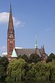
The Evangelical St. Gertrud Church , built in 1882–85 , is a neo-Gothic brick building based on a design by Johannes Otzen by the Kuhmühlenteich . With the rich use of shaped and glazed stones , it is an example of the church building style of the Hanover School . The geographical center of the city of Hamburg should be between the church and the Kuhmühlenteich.
A wide hiking trail with many benches runs along the banks of the Outer Alster. The Feenteich and the Imam Ali Mosque , built in 1961, as well as the guest house of the Senate of the Hanseatic city are also located here .
The merchant's villa at Schwanenwik 38 was built around 1865 and expanded to the rear with a ballroom in 1890. In 1985 the building was acquired by the ZEIT Foundation Ebelin and Gerd Bucerius and the newly founded Literaturhaus e. V. made available. The villa has been used as a literature house since 1989 . Every month 12 to 15 readings of contemporary international literature take place in the magnificent ballroom. The building also houses the “Literaturhauscafé” , the Samtleben bookstore , the Börsenverein des Deutschen Buchhandels and the Literaturzentrum e. V.
Sankt Gertrud
view over the cow mill pond
Sankt Gertrud
nave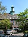
Heilandskirche on Winterhuder Weg

Imam Ali Mosque

Literaturhaus am Schwanenwik 38


Sports

- rowing
- Ruder -Gesellschaft "Hansa" e. V.
- sailing
- North German Regatta Association V.
- Sailing pier of the University of Hamburg
- Soccer
- HSV Barmbek-Uhlenhorst still has the district in its name, but plays in Barmbek-Nord
education
- Hamburg University of Fine Arts
- Hamburg University of Applied Sciences , Armgartstrasse location ("Fashion School")
- Lerchenfeld high school
- School on the Uhlenhorst
- private August Hermann Francke district school and grammar school
See also
- List of streets, squares and bridges in Hamburg-Uhlenhorst
- List of cultural monuments in Hamburg-Uhlenhorst
- List of stumbling blocks in Hamburg-Uhlenhorst
Individual evidence
- ↑ Uhlenhorst: Wissens- und Sehenssame , hamburg.de, accessed on March 3, 2020
- ↑ District boundaries of Hamburg-Uhlenhorst on Google Maps http://maps.google.de/maps/ms?hl=de&ie=UTF8&msa=0&msid=103475096124565310979.0004401184cdcf2143750&z=14&om=1
- ↑ Hamburger Abendblatt dated August 9, 2013.
- ^ A b c Gustav Bolland : "On the history of the Uhlenhorst and the adjacent part from Hohenfelde to the Mundsburger Kanal" in the journal of the Association for Hamburg History Volume XXIX , Verlag W. Mauke & Sons, 1928, pages 167-218
- ^ Horst Beckershaus: The names of the Hamburg districts. Where do they come from and what they mean , Hamburg 2002, ISBN 3-434-52545-9 , p. 124
- ↑ Hamburger Abendblatt from June 9, 2012
- ↑ hamburg.de: Uhlenhorst
- ↑ Quota of minors in the Hamburg districts in 2017
- ↑ Proportion of 65-year-olds and older in the Hamburg districts in 2017
- ↑ Proportion of foreigners in the Hamburg districts in 2017
- ↑ Unemployment rate in the Hamburg districts in 2017
- ↑ Statistical Office for Hamburg and Schleswig-Holstein (ed.): Hamburg District Profile 2016 (= NORD.regional . Volume 19 ). 2018, ISSN 1863-9518 ( Online PDF 6.6 MB [accessed February 12, 2018]).
- ↑ http://www.hvv.de/pdf/plaene/hvv_tarifplan_sum.pdf
- ↑ Archived copy ( Memento of the original dated February 4, 2012 in the Internet Archive ) Info: The archive link has been inserted automatically and has not yet been checked. Please check the original and archive link according to the instructions and then remove this notice.
- ↑ http://www.mopo.de/hamburg/sierichstrasse-auch-fuer-radfahrer-wird-s-kompliziert-17335180
- ↑ Hamburger Abendblatt dated August 9, 2013.
Web links
Alsterdorf | Barmbek-North | Barmbek-Süd | Dulsberg | Eppendorf | Fuhlsbüttel | Groß Borstel | Hoheluft-Ost | Hohenfelde | Langenhorn | Ohlsdorf | Uhlenhorst | Winterhude