
Winterhuder Weg (Hamburg)
| Winterhuder Weg | |
|---|---|
|
|
|
 |
|
| The Winterhuder Weg as part of the B 5 . | |
| Basic data | |
| place | Hamburg |
| District | Barmbek-Süd , Uhlenhorst |
| Created | 18th century or earlier |
| Hist. Names | Schillerstrasse (northwest section between Schenkendorfstrasse and Hofweg) |
| Connecting roads | Lerchenfeld or Schürbeker Straße (south); Am Langenzug (west) |
| Cross streets | Mundsburger Damm, Hamburger Strasse, Averhoffstrasse, Heinrich-Hertz-Strasse, Kanalstrasse, Zimmerstrasse, Beethovenstrasse, Schenkendorfstrasse, Mozartstrasse, Herderstrasse , Hebbelstrasse, Hofweg |
| use | |
| User groups | Pedestrian traffic , bicycle traffic , car traffic , public transport |
| Technical specifications | |
| Street length | 1260 meters |
The Winterhuder Weg is a main road , which for the most part of its route represents the border between the Hamburg districts of Barmbek-Süd and Uhlenhorst . For a good 900 meters, it is part of federal highway 5 . Today's northwestern part, which was previously called Schillerstrasse, is completely in the Uhlenhorst district.
The street is characterized by the fact that there is no uniform building fabric, but old buildings from the turn of the 20th century can be found alongside evidence of the reconstruction after the Second World War and a few new buildings. The section of federal highway 5 has four lanes, while the short northwest section has only one lane in each direction.
Name, history and history

The Winterhuder Weg derives its name from its course as a route from Mundsburg to Winterhude . It begins at the transition from Hamburger Strasse to Mundsburger Damm, at the level of the Mundsburg Center with its three characteristic residential towers from the 1970s. The center and the towers are now a listed building. For this, Heinrich Klingenberg's furniture haulage building , which was previously located at this point, had to be demolished. Before Klingenberg's forwarding agency there was an English biscuit factory at this point until 1919. The road then runs in four lanes as part of federal highway 5 to the northwest. At the intersection with Schenkendorfstrasse and Mozartstrasse, the B 5 bends north as Herderstrasse , while Winterhuder Weg continues to the west as a residential street with only one lane in each direction for around 350 meters to Hofweg.

According to plans by Fritz Schumacher , the infant house of the Hamburg orphanage was built in Winterhuder Weg 11 between Averhoff- and Heinrich-Hertz-Straße between 1914 and 1916 . Today it houses, among other things, a daycare center and, like most of the Schumacher buildings in Hamburg, is a listed building. Shortly behind it, on the corner of Heinrich-Hertz-Straße, was a water tower built in 1906, which was part of the same construction program as the Schanzenturm and today's planetarium in the city park . It had not been in operation since the 1920s and was badly damaged in World War II . In 1956 it was demolished to give the neighboring retirement home space to expand.
The Hamburg Senator Alexander Kähler ran a soap factory and oil refinery on property number 76, which is now a Shell petrol station , which GHG Binder continued to run at the beginning of the 20th century. Diagonally across the street between Mundsburger Canal and Zimmerstrasse was the Bottke & Scheve wood dealership on the double property Winterhuder Weg 29/31. In its place, an eight-story office building was built in 1972 by Helmut Greve .
The Evangelical Reformed Church in Hamburg relocated its Altenhof, which was founded in Neustadt in 1686, to Winterhuder Weg 98 in 1887. After being destroyed in the war, the residential complex for the elderly was initially only poorly repaired. From 1968 a combined old people's home and nursing home was built. It also houses a chapel of the Reformed denomination. At number 112 (previously 106) there was a cinema on the ground floor of a building from the Wilhelminian style that still exists today. It was founded in 1913 as "Uhlenhorster Lichtspiele". Later it was called "Alhambra Theater" and most of its existence since 1930 "Schauburg Uhlenhorst". Before it was closed in 1967, it was still called "Astoria". The characteristic entrance, which clearly stands out from the neighboring buildings, can still be seen today.
.jpg)
On the corner of Schenkendorfstrasse, at house numbers 55 to 63, there is a striking brick block of flats to which the neighboring buildings at Schenkendorfstrasse 26 to 30 and Hebbelstrasse 6 and 8 also belong. The buildings were built from 1926 to 1928 according to plans by Ernst Dehmlow and are listed as a whole as a whole. The plans to build a residential building with 48 apartments in the inner courtyard of the building complex, which was formerly used as the depot of a construction company and was legally designated as a basement garage, met with resistance from the house owners and their tenants in the mid-2010s, because one was too large Shading of the existing buildings was feared. An exemption from the provisions of Implementation Plan 288, which was initially granted by the District Office, which dates from 1957, did not exist before the administrative courts, as the building permit violated the requirement of consideration. As a result, the Hamburg-Nord district initiated a development plan procedure that provided for a slightly slimmed-down structure with only 45 apartments. The neighbors' appeals against this plan were unsuccessful in interim legal protection. Directly opposite is the Ensemble Mozartstraße 2, Winterhuder Weg 114 and 116, which was built according to plans by Carl Wendt and is also a listed building.

.30988.ajb.jpg)
In the suspended section, the former Schillerstraße, there is a primary school at number 126 with the school on the Uhlenhorst . This was built in 1903 as a double school for boys and girls at Schillerstraße 29 to 31. In 1939 it was divided into two organizationally separate schools for both sexes. After the school had only been poorly repaired after the war damage, it was closed from 1964 to 1976 for a complete renovation and then reopened as a primary, secondary and secondary school in Winterhuder Weg . Since 2003 it has been a pure primary school, which was initially called the Winterhuder Weg primary school before it was given its current name. Directly to the west is the Evangelical Lutheran Church of the Savior, which was built in 1928 according to plans by Emil Heynen . The church and the pastorates, also designed by Heynen, were built right next to the old parish hall from 1899, which was originally built by Gottlieb Rambatz and Wilhelm Jollasse for the St. Gertrud Church . The church was badly damaged by an air mine in October 1944 and was not inaugurated again until December 1951 by Regional Bishop Simon Schöffel . Both the school and the church ensemble are under monument protection.
At the northwest end of Winterhuder Weg, towards Hofweg, Anna MM Vogel KG erected an eight-storey residential building in the mid-1950s , which still forms the end of the street today. The petrol station built in connection with this building has now been replaced by a commercial building.
Fritz Lachmund characterized the road as an originally simple field path that led "over the marshy swamps and meadows of the Uhlenhorst to the then quite remote village of Winterhude". The road was then expanded and paved by 1846. Franz Heinrich Neddermeyer described in his work “On the Statistics and Topography of the Free and Hanseatic City of Hamburg and its Territory” as early as 1847 that the Winterhuder Weg spanned the Osterbek with a wooden bridge. It remains unclear where exactly the Osterbek crossing took place, i.e. whether the Winterhuder Weg already roughly followed today's route and then the bridge was at today's Mühlenkampbrücke, or ran further north. Today's north-western section towards Hofweg was called Schillerstraße until 1948, which, given the name at Neddermeyer, suggests a more northerly route. The renaming of the former Schillerstrasse took place in order to dissolve the identity of the name with Schillerstrasse in Altona-Altstadt .

Nowadays, the Winterhuder Weg no longer bridges waterways, but the Uhlenhorster Canal , coming from the Feenteich, ends on the west side of the road between house numbers 27 and 29 in a small, walled basin. In the 1950s, the Winterhuder was expanded to four lanes on the section between Hamburger Strasse and Schenkendorfstrasse.
Transportation
There is currently no rapid transit station in Winterhuder Weg itself. South of it is beyond the road course Hamburger Straße / Mundsburger dam of Metro Station Mundsburg the Metro Line 3 . In the planning for an underground line 4 , a station in Winterhuder Weg was planned. However, the planning was stopped in 1974 shortly before the start of construction in 1974 for financial reasons. A stop in Winterhuder Weg was also planned in the preliminary investigations for an Alster half-ring , which were also stopped in 1974 . This is where the U4 and Alsterhalbring should meet. In the current planning of an underground line 5 , a stop in Winterhuder Weg at the intersection with Beethovenstraße is planned.

On October 1, 1909, the new line 35 drove the tram through Winterhuder Weg for the first time . It came from Mühlenkamp and led via Mundsburg , Berliner Tor and the Elbe bridges to the Veddel . This route was later extended to Goldbekplatz or the free port. From 1925, line 27 also served Winterhuder Weg , coming from the Altona town hall via Schlump , Hallerstraße , Mittelweg and Mühlenkamp and then via Mundsburg, Landwehr , Hammer Landstraße to Diagonalstraße in Hamm-Süd. In 1955 the line system was redesigned and now the lines 14 ( St. Pauli , Eimsbüttel , Eppendorf , Winterhude , Uhlenhorst, Berliner Tor, Elbbrücken, Freihafen) and 15 ( Elbchaussee , Altonaer Rathaus, Eimsbüttel, Eppendorf, Winterhude, Uhlenhorst, Borgfelde) , Hamm ) through the Winterhuder Weg. Since line 15 was discontinued in March 1976 and line 14 in May 1977, the tram no longer runs through Winterhuder Weg.
Instead of the tram, bus line 106 first ran through Winterhuder Weg, which had replaced line 14 on the section from Eppendorf to Veddel. In 2001, the 106 became today's Metrobus line 25. This connects the Mundsburg train station with the Beethovenstrasse and Hebbelstrasse stops, both of which are on Winterhuder Weg. The two city buses 172 and 173 coming from the Mundsburg train station also serve the Beethovenstraße stop before they turn into the composer's quarter. At night, the night bus line 606 runs through Winterhuder Weg.
Stumbling blocks for victims of National Socialism
So far, nine stumbling blocks for victims of National Socialism have been laid in Winterhuder Weg : On the Uhlenhorster side in front of house number 73 there are four stones for the Seelenfreund family who were deported to Zbąszyń in 1938 as part of the Poland campaign and who were then murdered in occupied Poland during the Second World War . A stumbling block was laid in front of number 49 for Heinz Weidt, who had been arrested several times after 1933 and was most recently incarcerated in Fuhlsbüttel concentration camp in 1943 . He was “pardoned” on probation at the front, where his trace is lost. On the Barmbek side, in front of house number 86, four stones commemorate the Bezen family, whose members were murdered in 1942 in Łódź and Chelmno .

Heinz Weidt in front of Winterhuder Weg 49

Else Seelenfreund in front of Winterhuder Weg 73

Inge Seelenfreund in front of Winterhuder Weg 73
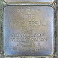
Lotte Seelenfreund in front of Winterhuder Weg 73

Moises Moritz soul friend in front of Winterhuder Weg 73

Aron Bezen in front of Winterhuder Weg 86

Bilha Erna Bezen in front of Winterhuder Weg 86

Erna Bezen in front of Winterhuder Weg 86

Leonhard Bezen in front of Winterhuder Weg 86
.Stolperstein.nnw.jpg)
.Stolperstein.nnw.jpg)
.Stolperstein.nnw.jpg)
.Stolperstein.nnw.jpg)
.Stolperstein.nnw.jpg)
.Stolperstein.nnw.jpg)
.Stolperstein.nnw.jpg)
.Stolperstein.nnw.jpg)
.Stolperstein.nnw.jpg)
Individual evidence
- ↑ Manfred Beseler, Mein Franzbrötchen , in: Claudia Thorn (Ed.), Mein Hamburg. Members of the Association for Hamburg History on their City , Books on Demand, Norderstedt 2014, ISBN 9783735791177 , page 161.
- ^ "Uhlenhorster water tower is being torn down" , in Hamburger Abendblatt of January 26, 1956, accessed on July 4, 2020.
- ↑ In his obituary 1907 there is the note: originally owner of the soap factories and oil refineries on Winterhuder Weg, later the GHG Binder company .
- ↑ “Office building will be built in just eight months” , in Hamburger Abendblatt of February 28, 1972, accessed on July 8, 2020.
- ^ "The home is still missing 200,000 marks" , in Hamburger Abendblatt of October 28, 1968, accessed on July 8, 2020.
- ^ "Living with the community" , at www.stiftung-altenhof.de, accessed on July 3, 2020.
- ^ "Uhlenhorster Lichtspiele" , on www.filmmuseum-hamburg.de, accessed on July 2, 2020.
- ↑ "Resolution of the OVG Hamburg dated November 6, 2019" , on www.rechtsprechung-hamburg.de, accessed on July 3, 2020.
- ↑ “Two New Houses of God” , in Hamburger Abendblatt of December 17, 1951, accessed on July 4, 2020.
- ^ "Hochhaus für Uhlenhorst" , in Hamburger Abendblatt from June 4, 1954, accessed on July 5, 2020.
- ↑ Fritz Lachmund, Der Winterhuder Weg: Retrospectives on the history of a suburban street, quoted from Matthias Schmoock, Between Image and Image: the development of the Hamburg district of Uhlenhorst and the representation in personal and third-party testimonials. From the first sources to building legislation in 1902 , dissertation University of Hamburg 2001, LIT Verlag, Münster Hamburg London 2002, ISBN 3825859630 , page 66.
- ↑ Matthias Schmoock, Between Image and Image: The Development of the Hamburg District Uhlenhorst and the Representation in Self and Third Party Testimonials. From the first sources to building legislation in 1902 , dissertation University of Hamburg 2001, LIT Verlag, Münster Hamburg London 2002, ISBN 3825859630 , page 66.
- ^ Franz Heinrich Neddermeyer, On the statistics and topography of the Free and Hanseatic City of Hamburg and its area , Hoffmann and Campe, Hamburg 1847, page 247.
- ↑ a b "U-Bahn in two-storey line" , in Hamburger Abendblatt dated November 24, 1969, accessed on July 8, 2020.
- ↑ “U5: Jarrestraße, Beethovenstraße, Uhlenhorst stops” , from www.schneller-durch-hamburg.de, accessed on July 1, 2020.
Coordinates: 53 ° 34 ′ 29.4 " N , 10 ° 1 ′ 17.5" E