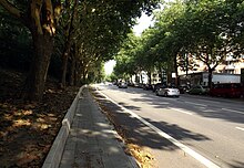
Hammer country road

The Hammer road is a 1.8-kilometer city road in Hamburg district of Hamm . Your official key number is H082. As an important link between Hamburg's city center and the eastern urban area ( Billstedt , Bergedorf ), it is part of Hamburg's main road network and is used by around 25,000 vehicles every day. Before the expansion of the Eiffestraße / Bergedorfer Straße road connection further south, the Hammer Landstraße formed a section of the federal highway 5 .
Location and development
The street begins at the Burgstraße underground station as a continuation of Borgfelder Straße and runs in an easterly direction below the Ice Age Geest slope , which traditionally divides the district into "Oben-Hamm" and "Unter-Hamm". The underground line to Billstedt (today U2 and U4 ) with the stops Burgstraße, Hammer Kirche and Rauhes Haus has been running in the slope since the 1960s - partly in an open cut . In addition, the HVV bus routes 31, 116 and 130 (the latter only towards the city) and the night bus route 609 run on Hammer Landstrasse. From the freight bypass railway , the street is called Horner Landstrasse.
Unlike before the Second World War , the street has only been built on on the south side since the reconstruction, while the north side was largely kept free and designed as a green corridor in view of the later subway construction . A few stumbling blocks here remind us that the street was also built on on the north side before the war. The south-facing buildings today mainly consist of apartment buildings with smaller shops, schools ( Louise-Weiss-Gymnasium , Vocational School for Vehicle Technology ), hotels and supermarkets.
history

Although, according to Beckershaus, it has only been officially named that way since 1931, the name Hammer Landstrasse (formerly Hammerlandstrasse ) has been in use for a long time and originally referred to the entire route from the respective Hamburg city gates ( Steintor , Berliner Tor ) in the direction of Hamm. The road was part of an army and long-distance trade route to Bergedorf and Lauenburg (Elbe crossing near Artlenburg ) and further eastwards that had existed since the Middle Ages .
Around today's Burgstrasse underground station, the road passed the Landwehr and was secured by a barrier (the “hammer tree”) that served as a customs station and entry control. Later the official seat of the governor , the highest official of the Hamm and Horn rulership , who exercised the lower jurisdiction over the inhabitants of the rural area on behalf of the Hamburg council, was also located here , which is why the official seat also included a prison.
From the 17th century, the street became increasingly popular with wealthy Hamburg merchants who built their summer houses and country houses and laid out magnificent gardens here. The names of numerous side streets still remind of the former owners.
Mayor Lukas von Bostel's garden near Gesundbrunnen, copper engraving from 1716
Landhaus Bödecker near Gesundbrunnen, built by Johann August Arens , copper engraving from 1809
Country house of Senator Johann Arnold Günther in front of the "Hammer Baum", around 1800
Villa Rücker, opposite today's Rauhes Haus underground station, built by Axel Bundsen , demolished in 1909
Villa of the "Guano King" Heinrich Ohlendorff , above today's Burgstrasse underground station, built by Martin Haller , destroyed in 1943
With the expansion of the Port of Hamburg and industrialization , buildings and population changed. From around 1900, the lower marshland south of the road was systematically piled up from the west and subsequently built on with tenement houses (including slit buildings ). When Villa Rücker, one of the last country houses in the area, was demolished in 1909 , the Museum of Hamburg History bought large parts of the interior to include in its permanent exhibition as a testimony to bourgeois living culture.
With the construction of the tram to Billstedt at the latest, Hammer Landstrasse developed into the main traffic and shopping street of the district, which grew to over 90,000 inhabitants by the beginning of the Second World War. During the Second World War, however, Hamm was largely destroyed in the course of Operation Gomorrah , so that little of the pre-war buildings has been preserved.
Confluence of the road at the Hammer Church in the Hammer Landstrasse. During the construction of the subway it was shortened and instead the Hammer Steindamm was extended down the slope of the Geest.
literature
- Gardens, country houses and villas of the Hamburg bourgeoisie. Art, culture and social life in 4 centuries (exhibition catalog), Museum for Hamburg History 1975.
- Ralf Wiechmann: From country house to tenement. In: Claudia Horbas (ed.): A country house in Hamm. The late Classicist Villa Rücker (1831–1909) and its residents. Edition Temmen Bremen 2012, ISBN 978-3-8378-2021-8 , pp. 32–59.
Web links
Individual evidence
- ^ Statistics Office North: Street and area index of the Free and Hanseatic City of Hamburg
- ↑ Map of the average daily vehicle traffic volume on working days (Monday – Friday), Hamburg 2013 (PDF file; 5.3 MB)
- ↑ Horst Beckershaus: The Hamburg street names. Where do they come from and what they mean. Hamburg 2011, p. 144 f.
- ↑ See e.g. B. the Hamburg city map from 1886 .
- ↑ Adolf Diersen: From the old rulership Hamm and Horn. Hamburg 1961.
- ↑ Claudia Horbas (ed.): A country house in Hamm. The late Classicist Villa Rücker (1831–1909) and its residents. Edition Temmen Bremen 2012, ISBN 978-3-8378-2021-8 .
Coordinates: 53 ° 33 '18.6 " N , 10 ° 3' 17.7" E


