
Herderstrasse (Hamburg)
| Herderstrasse | |
|---|---|
|
|
|
.jpg) |
|
| Herderstrasse with a view to the north. | |
| Basic data | |
| place | Hamburg |
| District | Barmbek-Süd , Uhlenhorst |
| Created | 18th century or earlier |
| Connecting roads |
Winterhuder Weg (south) Bachstrasse (north) |
| Cross streets | Mozartstrasse, Humboldtstrasse , Grillparzerstrasse, Schumannstrasse |
| use | |
| User groups | Pedestrian traffic , bicycle traffic , car traffic , public transport |
| Technical specifications | |
| Street length | 475 meters |
The Herderstraße is a main road in Hamburg-Nord . Since 1951 it has formed the border between the districts of Barmbek-Süd (east) and Uhlenhorst (west) along its entire length . It is part of the federal highway 5 .
The street is characterized by the fact that there is no uniform building fabric, but old buildings from the turn of the 20th century can be found alongside evidence of the reconstruction after the Second World War and a few new buildings. The entire route has been expanded to four lanes.
Name, history and history

Herderstrasse was named after the German poet Johann Gottfried Herder in 1865 . Until 1951 it was completely in the Uhlenhorst district . As a result of the change in the district boundaries, it has since formed the eastern boundary of the Uhlenhorst to the Barmbek-Süd district - just like the part of the Winterhuder Weg adjoining it to the south .
Herderstraße begins at the former northern end of Winterhuder Weg ⊙ (the part of Winterhuder Weg that bends to the west today was called Schillerstraße until 1948), from which it bends north at Mozartstraße. Then it leads straight ahead to the north until it takes a gently curved right-left curve at the confluence with Schumannstrasse and merges into Bachstrasse ⊙ .
Originally, Herderstrasse was single-lane in every direction. In 1959 the section between Winterhuder Weg and Grillparzerstraße was widened to two lanes in each direction. Up until the 1960s there was a machine factory (Schmidt & Söhne) on the corner of Bachstrasse, which had to give way to the four-lane expansion of the northern section of Herderstrasse. An eight-story residential building with shops on the ground floor was built on the remaining area that was not needed for the road expansion.
In the past there was also a Herderstrasse in the Altona-Nord district , but it was renamed Haubachstrasse in 1947 after the resistance fighter Theodor Haubach .
Transportation
Between Schumannstraße and Bachstraße, the vehicles of the city bus routes 172 and 173 drive in the direction of Barmbek station through Herderstraße. They do not serve any stops in Herderstrasse themselves. The Herderstraße stop is in the direction of Barmbek on Schumannstraße and into town on Bachstraße.
In the 1960s, a city bus route 71 was driving by the Borgweg to Dehnhaide wrong, by the Herderstraße.
Stumbling blocks for victims of National Socialism
Two stumbling blocks for victims of National Socialism were laid in Herderstrasse : On the Uhlenhorster side in front of house number 21 there is a stone for Emmy Nathan, a Jew who was murdered in Theresienstadt in 1944 . On the Barmbek side, a stone commemorates Alwin Knötsch, who was murdered in 1943 as part of the T4 campaign in the Hadamar killing center .
- Stumbling blocks

Emmy Nathan in front of Herderstrasse 21
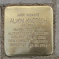
Alwin Knötsch in front of Herderstrasse 24
.Stolperstein.nnw.jpg)
.Stolperstein.nnw.jpg)
Web links
Individual evidence
- ↑ "Who is faster" , in Hamburger Abendblatt of April 23, 1959, accessed on June 6, 2020.
- ^ "Large Hotel in Barmbek" , in Hamburger Abendblatt of September 30, 1965, accessed on June 6, 2020.
- ^ "New bus route 71 now approved" , in Hamburger Abendblatt of September 29, 1962, accessed on June 6, 2020.
Coordinates: 53 ° 34 ′ 46 ″ N , 10 ° 1 ′ 9 ″ E