Hamburg old town
|
Hamburg-Altstadt district of Hamburg |
|
|---|---|
| Coordinates | 53 ° 33 ′ 0 ″ N , 10 ° 0 ′ 0 ″ E |
| height | 8 m above sea level NN |
| surface | 1.2 km² |
| Residents | 2350 (Dec. 31, 2019) |
| Population density | 1958 inhabitants / km² |
| Post Code | 20095, 20099, 20457, 20459 |
| prefix | 040 |
| district | Hamburg-Mitte district |
| Transport links | |
| Federal road |
|
| Subway |
|
| Train |
|
| Source: Statistical Office for Hamburg and Schleswig-Holstein | |
Hamburg-Altstadt (official name to demarcate Altona-Altstadt ) is the city center and belongs as a district to the Hamburg-Mitte district of the Free and Hanseatic City of Hamburg .
geography
The Hamburg-Altstadt district is centrally located in Hamburg between Neustadt , HafenCity and St. Georg . Its western part is part of downtown Hamburg . The Alsterfleet forms the border to Neustadt in the west ; to the south the old town is bounded by the Zollkanal , to the east and north by the tracks of the connecting railway and the Inner Alster.
history
The castles
In the area of the old town, the oldest settlement core of Hamburg was around the Domplatz . Hammaburg, destroyed by the Vikings in 845, was located here .
The 300 meter long Heidenwall , which protected the settlement to the east and ran from today's Rosenstrasse to Schopenstehl, was part of the fortification system .
Of the various castles built in the 11th century, the foundations of the bishop's castle can still be viewed in the basement of the St. Petri parish hall .
More details on settlement development in the main article History of Hamburg .
Old town
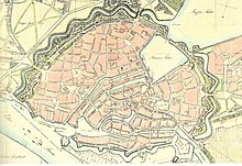
From 1240 the first parts of the ramparts were built . The course between the Alster and the Oberbaum corresponded to that of the later ramparts.
In the area of the old town there were the following city gates: Brooktor, Sandtor, Ellerntor, Winsertor, Niederntor, Steintor and Spitalertor. The Alster was dammed for the mill operation and parallel to the Rödingsmarkt in the middle of which a canal ran, a moat was created, which today forms the Alsterfleet and over which the Alster flows into the Elbe. The Nikolaifleet retained its function as the city's port.
To protect the harbor served in the West a number of tree stakes in the Elbe, they formed the Baumwall . In the east the port was protected from the Elbe and Bille by the Oberbaum .
The "old" new town
The name Neustadt goes back to the founding of the Count's town by Gustav Adolf III., Count zu Schauenburg, Stormarn and Holstein around 1188. The establishment stood in competition with the episcopal city around the Petrikirche in the area of the Domstrasse. Before that, there was the Count's New Castle , which is reminiscent of the street of the same name near the Nikolaikirche. The Trostbrücke has been connecting the two parts of the old town since 1266. The then old Neustadt is now part of the Hamburg district of Hamburg-Altstadt.
Expansion of the old town
The main church Sankt Jacobi and 1256 the main church Sankt Katharinen were first mentioned in 1255 . Both mentions document the expansion of the city to the east in the course of the Steinstrasse (Jakobikirche) and to the south in the Elbmarsch (Katharinenkirche). Until the settlement of Hamburg Neustadt (parish St. Michaelis ) in the 17th century, the old town of Hamburg consisted of the four parishes of St. Petri, St. Nikolai, St. Katharinen and St. Jakobi. These parishes also played an important role as organizational units in the administration of the city.
Canals were created to drain the area in the estuary delta of the Alster and Bille . They later served the movement of goods. Some canals became superfluous due to the construction of the warehouse district in the southern part of the parish of St. Katharinen (south of the Zollkanal ) in the 1880s. Around 20,000 residents were relocated. Other canals were filled with rubble after the Second World War.
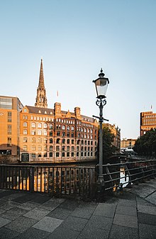
Several street names still remind of the old canals: Gröningerstraßenfleet, Steintwietenhof (former Deichstrassenfleet, over which the Steintwiete ran), Steckelhörnfleet and Katharinenfleet. Only the wide Nikolaifleet, the small basin of the Mönkedammfleet and the Alsterfleet remained . The beginnings of Steckelhörnfleet and Gröningerstraßenfleet can still be seen at the Katharinenbrücke and the Zollenbrücke .
Urbanization
After completion of the ramparts in 1624, work began on redesigning the course of the Alster in downtown Hamburg . The Alsterdamm (now Ballindamm ) was not built until 1624 .
Large parts of the old town were destroyed by the Hamburg fire in 1842. With the new construction, the narrow, medieval street structures and the often small parceled plots were abandoned and the opportunity was used to modernize the city. The most important architects of the time after the fire were Jean David Jollasse , Alexis de Chateauneuf and Auguste de Meuron , of whose buildings only the Alte Post has survived. The flourishing trade and later also the establishment of an empire led to changed needs in the design of the buildings. The lifting of the gate lock and the stations of the new railroad required a modified infrastructure to improve mobility.
From 1866, were starting with the construction of the railway station scapula - Hamburg Klosterthor Station , Hamburg's railway systems significantly redesigned. It was the Hamburg Central Station , who was then just in the district of St. Georg was opened 1906th In the same year, Mönckebergstrasse was laid out, under which Hamburg's first subway since 1912, with the Rathausmarkt (now Rathaus) and Barkhof (now Mönckebergstrasse ) stops, runs. In the area between Ballindamm on the Inner Alster and Steinstrasse , large office buildings and department stores were built, mostly with sandstone facades.
With the renovation of the southern old town, between the Deichtor and the Brandstwiete, the Zollkanal and the Steinstraße in the period from 1914 to 1938, the street network of the old town was given almost its current shape. The Kontorhausviertel replaced the last old streets in the Gängeviertel .
Individual areas
City courtyard
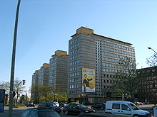
The City-Hof denoted a group of four high-rise buildings designed by the architect Rudolf Klophaus . Built in the 1950s and completed around 1958, these were the first skyscrapers in downtown Hamburg since the Klockmann House was built in the 1930s. In their original state, the facades of the City-Hof were clad with square, white ceramic tiles and structured by flush-fitting wooden windows. This situation was fundamentally changed in 1972 by the use of plastic windows and cladding of the facade with gray Eternit panels in 1977. The original ceramic facade was still preserved under the Eternit tiles. Also new for Hamburg was a shopping arcade that was not comparable with today's standards of so-called shopping experiences. Therefore, in addition to galleries for modern art, there are now shops for daily needs for employees in the Kontorhausviertel in the passage. The building complex was demolished in 2019.
Reichenstrasse
The former island, south of today's Große and Kleine Reichenstraße towards the main river of the Elbe, was settled around 850. It is the oldest settlement expansion from the Hammaburg out into the marshland. The area of the former island is bordered (according to today's street names) by the Trostbrücke in the west, the Große and Kleine Reichenstraße in the north and the Willy-Brandt-Straße in the south. In the east the Hopfensack was roughly the border. Where the Reichenstrasse areas are today, the Reichenstrasse Fleet used to be . The plots ran from the Fleet to the south to the Gröningerstraßenfleet, on the area of which Willy-Brandt-Straße runs today . While the residential and business premises were built towards the Reichenstraßenfleet, the granaries were in the direction of the Gröningerstraßenfleet.
From 1866 the Reichenstraßenfleet was filled in to create a wide street from the Berlin train station to the city center. One of the few remaining original components from Große Reichenstraße is the portal of the Cranz'schen Haus (Große Reichenstraße 49), which is now located in the ramparts near the Museum of Hamburg History .
Cremon
The marshland island of Cremon was diked in 1188 and assigned to the settlers of the Neue Burg as pasture. The island was settled a short time later. The houses were built towards the harbor on Nikolaifleet . A drainage ditch, later known as the Katharinenfleet , was dug behind the houses . The land on the other side of the Katharinenfleet initially continued to serve as pasture and was not built on until later. In the Middle Ages, an outside dike was built directly on Nikolaifleet.
Grim
The Grimm was settled soon after the Cremon. The settlement was similar to that of the older Cremon, but without a rear drainage canal. The main church of St. Katharinen, originally from the 13th century, is located on the Grimm . The parish was founded after the colonization of Cremon and Grimm for the spiritual care of the population of both islands.
Deichstrasse
Deichstrasse is on the other side of Cremon and Grimm . The area was built on from the New Castle around 1200. The port of Hamburg has been located on Nikolaifleet since the Middle Ages. The Great Fire of 1842 , which practically destroyed the entire core of the city at the time, broke out in Deichstrasse . The fact that the old structure was not torn down in the 1970s is thanks to the “Verein Rettet die Deichstraße” , which made it possible to restore various buildings with donations and the sale of souvenirs.
Pedestrian bridges over Willy-Brandt-Straße (formerly: Ost-West-Straße ) and the Zollkanal allow a touristic tour from the Rathausmarkt via the former main church St. Nikolai am Hopfenmarkt and the Deichstraße to the Speicherstadt .
Harbor on Nikolaifleet
Since the 12th century, the Nikolaifleet has developed into Hamburg's main hub. Since both the ebb (due to low water) and high tide (because of the bridge crossings) it became more and more difficult for the larger ships to enter and exit, an Elbe port was built.
Shopping area
Between the Kleine Bäckerstrasse and the Schopenstehl , the old fish market was located south of the then cathedral until the end of the 19th century .
In 1910, the Mönckebergstraße was broken through the old buildings to relieve the Steinstraße . It was designed as the main shopping street and soon overtook the previous first address, Großer Burstah . Together with the surrounding other shopping streets, it forms the center of the inner-city Hamburg “shopping” area. There is hardly any residential development in this area of the old town.
Kontorhausviertel
Churches
Hamburg was originally divided into four parishes : St. Jacobi , St. Katharinen , St. Nikolai and St. Petri . St. Michaelis in the Neustadt was added later as the fifth parish . With the Reformation, which was carried out in Hamburg by Johannes Bugenhagen , Hamburg became Lutheran. French Reformed and English Anglicans were only able to legally worship in Hamburg thanks to the regulations governing foreign relatives. The Roman Catholic community, on the other hand, had to resort to the private chapel in the imperial embassy for a long time and was only assigned to the service of Little Michel in the Neustadt at a late stage .
The old Mariendom was located between the streets Speersort and Schopenstehl from the 13th century to 1805 .
Population development
The quarter is characterized by department stores, shops and office buildings. There are only a few apartments left; they are located in the late buildings of the Kontorhausviertel. In the 1930s, when these buildings were built, there was no need for additional office space. In the area of the Katharinenfleet west of the Katharinenkirche, new apartments were built in the 1970s.
- Residents
- 2004: 1,774
- 2006: 1,556
statistics
- Minor quota: 12.0% [Hamburg average: 16.3% (2017)].
- Elderly rate: 11.1% [Hamburg average: 18.2% (2017)].
- Proportion of foreigners: 22.0% [Hamburg average: 17.1% (2017)].
- Unemployment rate: 5.4% [Hamburg average: 5.2% (2017)].
The average income per taxpayer in the old town is 31,336 euros annually (2013), the Hamburg average is 39,054 euros.
politics
For the election to Hamburg citizenship and the district assembly , Hamburg-Altstadt belongs to the Hamburg-Mitte constituency . The 2015 state election led to the following result:
- SPD : 39.1% (-10.1)
- Left : 15.6% (+7.6)
- Greens : 13.6% (-1.6)
- CDU : 10.7% (−6.3)
- FDP : 8.9% (+4.8)
- AfD : 6.8% (+6.8)
- Others: 5.3% (-1.0)
Museums
The Hamburger Kunsthalle is right next to the main train station . In the new building ( gallery of the present ) art of the 20th century is exhibited.
theatre
The Thalia Theater is the second largest theater in the city.
media
See also
- List of streets, squares and bridges in Hamburg's old town
- List of cultural monuments in Hamburg's old town
- List of stumbling blocks in Hamburg's old town
Web links
Individual evidence
- ^ Map from 1250 from EH Wichmann: Atlas for the history of Hamburg, 1896, at historical maps of Hamburg
- ^ Ralf Lange : Architecture in Hamburg - The great architecture guide. Junius, Hamburg 2008, ISBN 978-3-88506-586-9 , pp. 6, 11.
- ^ Manfred F. Fischer : The Chilehaus in Hamburg. Architecture and vision. With 28 plates by Klaus Frahm, Gebr. Mann Verlag, Berlin 1999, ISBN 3-7861-2299-7 , p. 16.
- ↑ Quota of minors in the Hamburg districts in 2017
- ↑ Proportion of 65-year-olds and older in the Hamburg districts in 2017
- ↑ Proportion of foreigners in the Hamburg districts in 2017
- ↑ Unemployment rate in the Hamburg districts in 2017
- ↑ Statistical Office for Hamburg and Schleswig-Holstein (ed.): Hamburg District Profile 2016 (= NORD.regional . Volume 19 ). 2018, ISSN 1863-9518 ( Online PDF 6.6 MB [accessed February 12, 2018]).
- ↑ http://www.wahlen-hamburg.de/wahlen.php?site=left/gebiete&wahltyp=3#index.php?site=right/result&wahl=973&gebiet=34&typ=4&stimme=1&gID=4&gTyp=2


